 Town Of Mount Pleasant, SC 'Key To The City' Geo-Goodwill Ambassador
| Trackable Options |
 Found this item? Log in.
 |
 Printable information sheet to attach to Town Of Mount Pleasant, SC 'Key To The City' Geo-Goodwill Ambassador
Print Info Sheet
Printable information sheet to attach to Town Of Mount Pleasant, SC 'Key To The City' Geo-Goodwill Ambassador
Print Info Sheet |
| There are 4 users watching this listing. |
-
Owner:
-
mtpleasantplanning
Message this owner
-
Released:
-
Tuesday, August 4, 2009
-
Origin:
-
South Carolina, United States
-
Recently Spotted:
-
Unknown Location
The owner hasn't set their collectible preference.
Use TB2TF5P to reference this item.
First time logging a Trackable? Click here.
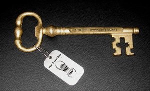
The "Key to the City" is a Geo-Goodwill Ambassador of the Town of Mount Pleasant, South Carolina. It’s mission is to visit towns, cities, and villages in the United States and around the world. Protocol for hosting the Key to the City Geo-Goodwill Ambassador is to post a photograph of yourself and the key in front of your town hall or an iconic landmark in your town. Post the photographs in the gallery on this page.
Francais:
La "Clé de la ville" est un « travel bug » géocacheur de la ville de Mount Pleasant provenant de l’état de la Caroline du Sud aux Etats Unis. Cette clé a pour mission de visiter les villes et villages du monde entier. Si vous trouvez cette clé, le protocole d’accueil est très simple. Postez une photo de vous et de la clé en face de votre mairie ou un monument emblématique de votre ville. Postez vos photos dans la galerie sur cette page.
www.tompsc.com
Originally occupied by the Sewee Indians, Mount Pleasant’s first European settlers arrived from England on July 6, 1680, under the leadership of Captain Florentia O’Sullivan. Captain O’Sullivan had been granted 2,340 acres which included not only the island that bears his name, but also the land that was to become Mount Pleasant. In 1696, fifty-one new settlers arrived. Each family was allotted several hundred acres in the area that became known as Christ Church parish. In 1706 a joint attack of Spanish and French troops were defeated in Mount Pleasant saving the fledgling British Province of Carolina.
Revolutionary War
Mount Pleasant played a leading role in the first major military engagement – and victory – of the Revolutionary War at Fort Moultrie. Later in the war, when Charleston finally fell to the British on November 12, 1775, Cornwallis crossed the Cooper River with 2,500 troops and took possession of the town establishing the British headquarters at the home of Jacob Motte, later known as Hibben House.
Incorporation
The area known today as “Mount Pleasant” was comprised of four small villages along Charleston Harbor. On December 20, 1837, the village of Greenwich was merged with Mount Pleasant and incorporated under the name Mount Pleasant.
Civil War
On September 24, 1860 a public meeting was held in Mount Pleasant that produced the first secession resolution of the state. The secession convention met in Charleston December 20, 1860 and seven southern states formed the Confederate States of America. With the advent of the Civil War, Battery Gary and an adjacent floating battery between Mount Pleasant and Sullivan’s Island were instrumental in defense of the town, as well as attacks on Fort Sumter. The Town was also defended by a line of fortifications from Elliot’s Creek at Boone Hall to Copahee Sound. Mount Pleasant was also the secret training ground for the nine-man crew of the Confederate submarine CSS Hunley. It was from Breach Inlet in 1864 that this small vessel was launched to attack and sink the Housitanic.
Late 19th Century
Twenty years after the war, Mount Pleasant was populated by 783 residents. Four miles of street were laid with shells and the town was known as a pleasure and health resort for the planters of Christ Church parish and people of Charleston. Stores and dwellings rented for ten and twenty dollars a month. Truck farming was a major occupation and Mount Pleasant was the site of a sawmill and brick factory. There were nine stores, mostly owned by residents of German origin. A steam ferry provided transportation between Charleston and the Village until the first Cooper River Bridge was built in 1929. A newspaper article in 1889 reported, “The health of Mount Pleasant has been unprecedentedly fine for the past year. The town council expends about $2,000 on the streets and other necessary improvement, and the money is so judiciously applied that Mount Pleasant, in regard to general appearance, is one of the model towns of the state.” Mount Pleasant continues to stand as a model town, not only in South Carolina, but also in the nation.
Today, Mount Pleasant is the fourth largest city in South Carolina with a population of 72,000 residents. www.tompsc.com
(Summary adapted from the History of Mount Pleasant article in Mount Pleasant, S.C. Sesquicentennial Souvenir Program and Scanlonville, Charleston County, South Carolina: the community and the cemetery, prepared by Michael Trinkley and the Chicora Foundation, 2001) To learn more visit (visit link)
Gallery Images related to Town Of Mount Pleasant, SC 'Key To The City' Geo-Goodwill Ambassador
 Freeport Covered Bridge Quebec, Canada
- USS Yorktown, Patriots Point, Mount Pleasant, SC
- Medal of Honor Museum, Mount Pleasant, SC
- Medal of Honor Museum, Mount Pleasant, SC
- 17th Green, Patriots Point, Mount Pleasant, SC
- Christ Church, Mount Pleasant, SC
- Darby Building, Mount Pleasant, SC
- Pitt St. Pharmacy Soda Fountain Mount Pleasant, SC
- Holy Ascension Orthodox Church, I'On, Mt. Pleasant
- Blessing of the Fleet Festival, Mount Pleasant, SC
- Shem Creek, Mount Pleasant, SC
- Fuel Dock, Shem Creek, Mount Pleasant, SC
- Shrimp Boats, Shem Creek, Mount Pleasant, SC
- Pickett Bridge Recreation Area, Mount Pleasant, SC
- Pickett Bridge Recreation Area, Mount Pleasant, SC
- Alhambra Hall, Mount Pleasant, SC
- Snee Farm, Mount Pleasant, SC
- Ravanel Bridge, Mount Pleasant, SC
- Alligator, Dunes West, Mount Pleasant, SC
- Wagner Creek, Dunes West, Mount Pleasant, SC
- Field, Boone Hall, Mount Pleasant, SC
- Cotton Dock, Boone Hall, Mount Pleasant, SC
- Boone Hall Slave Cabins, Mount Pleasant, SC
- Oak Allee, Boone Hall, Mount Pleasant, SC
- Town Of Mount Pleasant Traveling Key To The City
View All 37 Gallery Images
Tracking History (2183mi) View Map
|
nobellium discovered it
|
|
Visit Log
|
Clé imposante! Vu au Pont couvert "Freeport"
|
|
PeterGail placed it in Pont couvert "Freeport" Covered Bridge
|
Québec, Canada
- 42.88 miles
|
Visit Log
|
|
|
|
PeterGail took it to Pont couvert "Freeport" Covered Bridge
|
Québec, Canada
- 42.88 miles
|
Visit Log
|
|
|
|
PeterGail retrieved it from Bestiaire 11 - Le lapin cochon !
|
Québec, Canada
|
Visit Log
|
Impressive TB, very nice, will need a big cache for this one
|
|
jolie002 discovered it
|
|
Visit Log
|
Vu dans la cache [url=http://www.geocaching.com/seek/cache_details.aspx?guid=9575a0a5-9432-4f39-9586-0988bb2cd3db#]Bestiaire 11- Le lapin cochon[/url]. Trop gros pour moi, je le laisse là!
|
|
feedesboisees placed it in Bestiaire 11 - Le lapin cochon !
|
Québec, Canada
- 19.8 miles
|
Visit Log
|
|
|
|
feedesboisees retrieved it from Bestiaire 9 - Donky Kong
|
Québec, Canada
|
Visit Log
|
Ça prend juste moi pour me tromper de cache... Je le replace comme il faut...
|
|
feedesboisees placed it in Bestiaire 9 - Donky Kong
|
Québec, Canada
- 19.56 miles
|
Visit Log
|
|
|
|
feedesboisees grabbed it
|
|
Visit Log
|
Comme les farfadets chanteurs avaient moins le temps de faire du geocaching, Ils m'ont confié ce magnifique trackable pour que je le relocalise.
|
|
lesfarfadetschanteur grabbed it
|
|
Visit Log
|
merci pour le beau cadeau
|
|
data on this page is cached for 3 mins
|