 MilanoXX's Mariner's Astrolabe Geocoin
| Trackable Options |
 Found this item? Log in.
 |
 Printable information sheet to attach to MilanoXX's Mariner's Astrolabe Geocoin
Print Info Sheet
Printable information sheet to attach to MilanoXX's Mariner's Astrolabe Geocoin
Print Info Sheet |
|
-
Owner:
-
milanoxx
Message this owner
-
Released:
-
Wednesday, December 16, 2009
-
Origin:
-
Středočeský kraj, Czechia
-
Recently Spotted:
-
In the hands of the owner.
This is collectible.
Use TB32GNQ to reference this item.
First time logging a Trackable? Click here.
Mince bude navštevovat hezká místa a eventy. Od majitele se nehne ani na krok :)
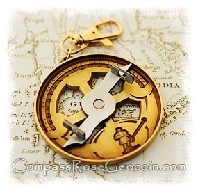
This huge geocoin is a working replica of a Mariners Astrolabe. The mariner's astrolabe, also called sea astrolabe, is not a proper astrolabe, but rather a graduated circle with an alidade used to measure vertical angles. In the sixteenth century, the instrument was also called a ring.
The mariner's astrolabe would have replaced or complemented instruments such as the cross staff or quadrant as a navigator's instrument. The mariner's astrolabe was used until the middle or, at the latest, the end of the 17th century. It was replaced by more accurate and easier-to-use instruments such as the Davis quadrant. In order to use the astrolabe, the navigator would hold the instrument by the ring at the top. This caused the instrument to remain in a vertical plane. He would align the plane of the astrolabe to the direction of the object of interest. The alidade was aligned to point at the object and the altitude was read off the outer degree scale.
How to use mariners astrolabe:
Taking a latitude reading from the North Star Polaris:
1. Grasping the ring, hold the astrolabe up in the air towards the North Star.
2. Line up the holes in the spinning alidade so that you can see Polaris through them.
3. Take the reading from the degree scale and you now have your latitude.
Gallery Images related to MilanoXX's Mariner's Astrolabe Geocoin
View 1 Gallery Image
Tracking History (335.3mi) View Map