 Onu's Mariner's Astrolabe Geocoin
| Trackable Options |
 Found this item? Log in.
 |
 Printable information sheet to attach to Onu's Mariner's Astrolabe Geocoin
Print Info Sheet
Printable information sheet to attach to Onu's Mariner's Astrolabe Geocoin
Print Info Sheet |
|
-
Owner:
-
Onu
Message this owner
-
Released:
-
Sunday, June 12, 2011
-
Origin:
-
Agder, Norway
-
Recently Spotted:
-
In the hands of the owner.
This is not collectible.
Use TB4FJHC to reference this item.
First time logging a Trackable? Click here.
Its mission is to measure Onus travels across the planet on her ceocaching adventures.
Fully workable replica of a marine astrolabe. Its a reminder of the navigations humble beginnings. It was used to measure latitude (north-south position). It was developed in the 1400s and saw continued use until the 1700s when the sextant took over (witch made it possible to get both latitude ans longditude).
It is a brass disk that is marked in degrees and has a spinning alidade. The two holes on the spinning alidade are small enough to get a fairly precise reading from sunlight, but are large enough to see through when taking a reading of the North Star, Polaris. The distinctive large holes in the disk were to reduce its movement in light winds. It was designed to have a much simpler function and did not contain several moving disks which the planispheric astrolabe had that were difficult to utilize on a tossing ship.
How to use it:
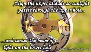
Measuring the declination of the sun at high noon:
1. Grasping the top ring, hold the astrolabe to about chest high.
2. Looking down on the alidade, let the sun shine directly though the upper alidade hole.
3. Adjust the alidade so that the beam of sunlight shinning through the upper hole passes through the lower hole.
4. Now you can take a reading from the degree scale and see the declination of the sun.
Taking a latitude reading from the North Star, Polaris:
1. Grasping the ring, hold the astrolabe up in the air towards the North Star.
2. Line up the holes in the spinning alidade so that you can see Polaris through them.
3. Take the reading from the degree scale and you now have your latitude.
Gallery Images related to Onu's Mariner's Astrolabe Geocoin
View All 4 Gallery Images
Tracking History (32132.4mi) View Map
|
Onu took it to Bragdøya Kystkultursenter
|
Agder, Norway
- 26.67 miles
|
Visit Log
|
|
|
|
Onu took it to Urdalstjønnhelleren
|
Agder, Norway
- .17 miles
|
Visit Log
|
|
|
|
Onu took it to Svandalshelleren
|
Agder, Norway
- 1.04 miles
|
Visit Log
|
|
|
|
Onu took it to BVS 6-21
|
Agder, Norway
- .16 miles
|
Visit Log
|
|
|
|
Onu took it to BVS 6-20
|
Agder, Norway
- .16 miles
|
Visit Log
|
|
|
|
Onu took it to BVS 6-19
|
Agder, Norway
- 4.42 miles
|
Visit Log
|
|
|
|
Onu took it to Nyttårs-cito
|
Agder, Norway
- 22.46 miles
|
Visit Log
|
|
|
|
Onu took it to Grimstad Tog Stasjon
|
Agder, Norway
- 23.77 miles
|
Visit Log
|
|
|
|
Onu took it to BVS 6-07
|
Agder, Norway
- 3.82 miles
|
Visit Log
|
|
|
|
Onu took it to Engler daler ned i skjul
|
Agder, Norway
- 2.92 miles
|
Visit Log
|
|
|
|
data on this page is cached for 3 mins
|