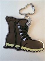
 Mt. Lafayette - NH 4,000'er Series #6 of 48
| Trackable Options |
 Found this item? Log in.
 |
 Printable information sheet to attach to Mt. Lafayette - NH 4,000'er Series #6 of 48
Print Info Sheet
Printable information sheet to attach to Mt. Lafayette - NH 4,000'er Series #6 of 48
Print Info Sheet |
| There is 1 user watching this listing. |
-
Owner:
-
pulmonaryhip
Message this owner
-
Released:
-
Saturday, July 16, 2016
-
Origin:
-
New Hampshire, United States
-
Recently Spotted:
-
Unknown Location
This is not collectible.
Use TB4WNP1 to reference this item.
First time logging a Trackable? Click here.
To hike with geocachers on trails all over the world.
New Hampshire, USA has 48 mountains over 4,000' (1,200 m) high. Since 1957, the Appalachian Mountain Club has awarded just over 10,000 hikers admission to the AMC Four Thousand Footer Club for climbing all 48 peaks in a lifetime.
Mt. Lafayette (5,249' or 1,600 m) is the northern peak on Franconia Ridge. It has wonderful views on a clear day. It was named for General Lafayette, a French general who aided George Washington and the Continental Army during the American Revolutionary War. Lafayette later made a tour of New Hampshire and other states in 1824-25 to celebrate the 50th anniversary of the Battle of Bunker Hill.
The classic hike is to do a loop over Mts. Lincoln and Lafayette by heading up the Falling Waters Trail, across the ridge over Little Haystack, Mt. Lincoln, and Mt. Lafayette before descending on the Bridle Path. This hike is 8.9 miles with 3,900 feet of elevation gain. The views are spectacular, if the weather is cooperative. But it can be life-threatening if the weather is bad. To hike Mt. Lafayette alone, you hike up the Bridle Path to the AMC Greenleaf Hut, then climb the Greenleaf Trail for a mile above treeline before reaching the summit. Returning the same way gives a hike of 8.0 miles with 3,600' of elevation gain. Another option is to hike the Greenleaf Trail the entire way, going through spectacular Eagle Pass. Using the Greenleaf Trail is a hike of 7.6 miles with 3,300' of elevation gain. A longer option is to use the Skookumchuck and Garfield Ridge Trail to hike from the north. This hike is 10.2 miles roundtrip with 3,550' of elevation gain. Since the AMC Mt. Greenleaf Hut is a mile below the summit of Mt. Lafayette, it is possible to do any of these hikes over two days by overnighting at the hut.
Gallery Images related to Mt. Lafayette - NH 4,000'er Series #6 of 48
View 1 Gallery Image
Tracking History (5253.7mi) View Map
|
davidandry discovered it
|
|
Visit Log
|
Discovered during our quarantine due to the corona virus, thanks a lot to the owner for sharing his beautiful collection with us, we wish him a 2021 full of geocaching and excellent health.
Claudia and Daniele, Castelfranco Veneto - Italy
|
|
Tots4junts discovered it
|
|
Visit Log
|
Thanks for sharing!!! Grettings from Catalunya!
|
|
JeffBergziege discovered it
|
|
Visit Log
|
Nice boot series!
PulmonaryHip gave me the possibility to discover!
Thank you for sharing.
Good luck and best wishes in these strange times!
Stay healthy!
Greetings from the western part of Germany near Aachen.
|
|
Zaubermaus606 discovered it
|
|
Visit Log
|
Thanks to PulmonaryHip for allowing me to discover this great collection for a challenge
Greetings from rainy Germany
zaubermaus606
|
|
Duo Baculi discovered it
|
|
Visit Log
|
Thanks for sharing and greetings from Austria!
|
|
little-leggs discovered it
|
|
Visit Log
|
Thank you to PulmonaryHip
for allowing me to Discover this one and more
great collection
😁
LiTTLE-LEGGS
|
|
Chembrat discovered it
|
|
Visit Log
|
Discovered it. Thank you for sharing.
|
|
MusicAthleteJB placed it in Moon Book Repository
|
Pennsylvania
- 24.39 miles
|
Visit Log
|
This was an outstanding hike and a great view of the Ohio river. I did enjoy a few nice treks with it before finally finding a worthy location for it to rest. Hopefully this will get picked up & moved along soon.
|
|
MusicAthleteJB took it to COL CO.MID 184
|
Ohio
- 7.14 miles
|
Visit Log
|
|
|
|
MusicAthleteJB took it to SQ - New Waterford
|
Ohio
- 22.67 miles
|
Visit Log
|
|
|
|
data on this page is cached for 3 mins
|