 Belgian Geocoin
| Trackable Options |
 Found this item? Log in.
 |
 Printable information sheet to attach to Belgian Geocoin
Print Info Sheet
Printable information sheet to attach to Belgian Geocoin
Print Info Sheet |
|
-
Owner:
-
Badfire2
Message this owner
-
Recently Spotted:
-
Unknown Location
The owner hasn't set their collectible preference.
Use TB13XM1 to reference this item.
First time logging a Trackable? Click here.
Go from cache to cache around the world without being stolen or lost. Pictures are welcome!
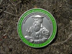
The Mercator projection is a cylindrical map projection presented by the Flemish geographer and cartographer Gerardus Mercator, in 1569. It became the standard map projection for nautical purposes because of its ability to represent lines of constant true bearing or true course, known as rhumb lines, as straight line segments.
Gallery Images related to Belgian Geocoin
View All 2 Gallery Images
Tracking History (3283.2mi) View Map