6/2003: This is another quality cache that is intended for the
motivated adventurer and, although it actually the little brother
to the first one, it has plenty high-quality goodies in it to
reward your quest (I will always to do this for these tough Alpine
caches!).
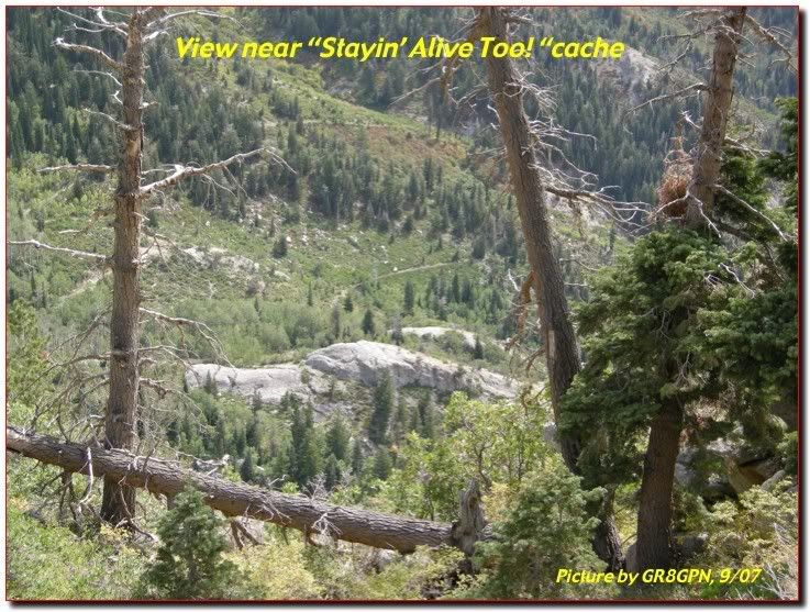
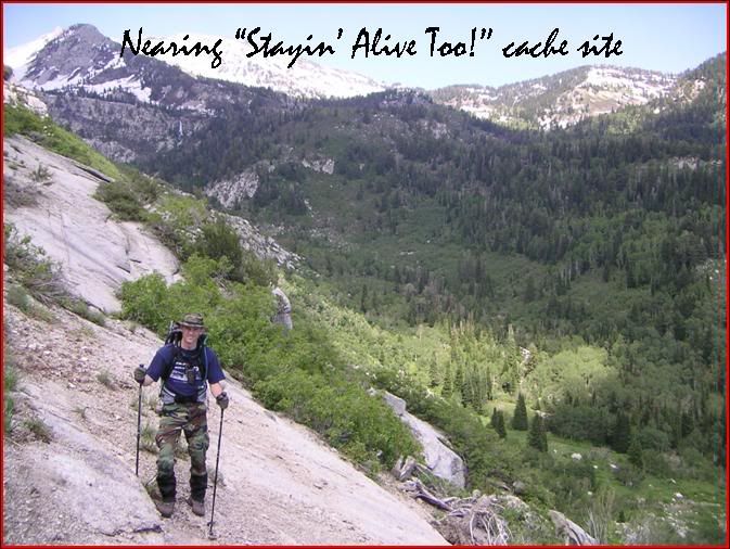
"Stayin' Alive Too!" is located near Alpine and begins at a
popular makeout location at the Dry Creek Trailhead. It's a heavily
used, sometimes dusty, moderately difficult trail that will climb
into beautiful stands of quaking aspens and evergreens with a
gushing "river" nearby to serenade your steps. Note the change
valley fauna to alpine fauna as you ascend. Beautiful! All in all,
the views are impressive, the trail is well maintained up to the
crossing point (for the most part), the wildflowers are wondrous,
and the treasure will be worth it.
Unfortunately, you'll also be dodging "horse apples" on the
trail and it gets very rocky in places due to the horse traffic
tearing it up. Good footwear and prudent foot placement will
prevent a twisted ankle. And if you are a horse traveler, please
leave them at home on this one. There's no way they'd make it to
the top (unless you have one like in the "Man From Snowy
River")
You will almost entirely follow the trail, but the terrain will
become markedly more challenging as you approach the cache and you
will have to make some decisions. During spring and early summer
runoff, expect and prepare to cross a small but furious river (in
addition to several creeks along the way). Be careful here.
Bringing children or city slickers is ill advised. Trekking poles
help a lot here.
Getting nearer to the find, you'll have to bushwhack you're way
up there. There are no discernible trails around so you'll be
working but just remember as you curse me for the difficulty, the
end product will be worth it. Make the find more memorable by
bringing a lunch and dining at altitude.
Expect to spend 3-5 hours reaching and finding "Stayn' Alive
Too!" and you'll gain about 2600' in elevation. Hiking out
(returning) at night time is doable and can be done safely (I do
not recommend this on "Stayn' Alive 1"): I hiked out at 11:30pm
without too much difficulty and a little companion in tow (SEE
"Abby's Rescue cache).
As before this will be a rugged hike anyway you go, bring lots
of water and maybe a filter. But its isolation is what makes it
special. Saw a fawn, multiple deer, snakes, a fox, and lots of elk
sign today. A rewarding hike!
>>>> 6/29/05: After Roadstr's heads-up I went up
today with a friend to replace cache. Amazed to find cache missing
(!) but came prepared. Camo'd .50 cal ammo can replaced original
cache today. Filled with high quality trade items so come prepared
and absolutely no geocrap! NO THEME ANYMORE, just take pride in
your trades please (see pic for contents). The location was also
moved about .10 miles to the west at a better hiding location and
coordinates posted with a Garmin GPS 60CS with WAAS for better
accuracy. The original location is now the home to micro cache
"Cougar."
>>>> 9/15/07: Cache in great shape with good trade
items. Thanks for that.
TREKKING AIDS:
- DRYCREEK TRAILHEAD AND PARKING: N 40° 28.962 W 111°
45.031
- STAY TO THE RIGHT AT THIS POINT ON TRAIL FOR EASIER ACCESS
TO RIVER CROSSING POINT: N 40° 30.159 W 111° 43.380. If you go
left, you're in for a hellacious bushwhack.
- SAFE CROSSING POINT ACROSS THE RIVER TO THIS CACHE: N
40° 30.376 W 111° 43.141. It's a safe 3 foot jump. This will be
less of a player if the spring run-off is not in progress. If it
is, this creek can be a dangerous river.
- CACHE ORDER SUGGESTION: After logging Abbey's Rescue, do
Cougar, Stayin' Alive Too, Wild America, then Moxie. You will
double back a bit on this order but the best line to go up is
towards Cougar cache.
- SUGGESTED EQUIPMENT: Long pants, gaitors, pair of good
hiking poles, 1.5 gallons of water, Gatorade or other electrolyte
mix (some in party may need this bad as they didn't hydrate and
this can prevent dizziness or fainting), first aid kit, cell phone
(you'll have coverage), extra batteries (everyone always runs out
up here), good sturdy and broken-in hiking boots (no tennis shoes;
one cacher had them and her feet bottoms got badly bruised and
beaten by the trail rocks).
- DOGS: Your dog will have to be in great shape and
"mountain-qualified" i.e. be able to negotiate and tackle heavy
brush, rock jumping, boulder scrambling, and steep, smooth rock
face climbs with confidence. If they aren't up to it and
experienced in this, I suggest leaving them at home unless you want
to carry them out. Even an in-shape dog will be exhausted after
your hiking day is over. Also your dog should be trained and
well-mannered around horses (i.e. no barking, chasing) as you can
encounter many on the trail.
- TIMING: With a leisurely and enjoyable pace, plan on
being on the trail 11 hours to log all the caches up
there.
CoolCache's Dry Creek Trail Caches: Hitting all of these will
take most of the day... start early! Several other good caches are
in the area too making your visit up here productive. Finally all
my upper caches are rated 5/5 to reflect the effort involved even
though they are all easy finds once there (as it should be!)