Introduction
When I was in high school, history was my least favorite subject. However, as I've grown older, history has become more and more fascintating. Palmer is home to some very interesting rail history, but there is much more to Palmer than the rail lines, and hopefully, this multi-cache will make for an enjoyable and interesting trip back in time.
This multi-cache will take you to multiple locations in Palmer, including all four of the villages that make up Palmer today. If done in order, the trip will take you on a 15 mile tour of Palmer (where you will collect some necessary data), and the physical cache will take an approximately 10 minute walk to locate.
Driving directions will be in bold, and nearby cache info in italics.
Before we get started, to whet your geocaching whistle, read this little tidbit on Palmer:
Was Palmer the site of the very first multi-cache?
Palmer is home to it's share of legends, but one of the most intriguing is that of the Captain Kidd letter found on the property of Samuel Shaw in 1849. Legend has it that two young Shaw men were out hunting rabbits when their dog chased one under a stone ledge. They reached in and found a glass vial tightly sealed with sheet lead and wound in wire. Brought to the house, the bottle had to be broken to be opened, and inside was a roll of paper dated 1700-1, the old method of dating 1701.
The paper was a letter from Robert Kidd and addressed to John Bailey Esq. of New York. The letter stated that Kidd had been captured as a pirate, and was to be sent back to England for trial. Further, Kidd instructed Bailey to go to Conant’s Island in Boston Harbor to find 2 chests "containing from fifteen to twenty thousand pounds sterling, in money, jewels and diamonds." The letter goes on to give specific information on where the chests are located and cautions Bailey to say nothing about the letter, to "keep dark to any but my friends." The courier was instructed to hide the vial if he met with trouble or was taken by Indians, and return for it if he was able to escape.
The discovery of this letter 148 years later caused a major stir in town. The great debate was over whether the letter was genuine and if there really was a treasure buried in Boston Harbor. Samuel Shaw later that year went to Conant’s Island, by then renamed Governor’s Island. By the time Shaw arrived its name was not the only thing that had changed. The shores of the island had eroded and the coastline altered. The area where the chests were to have been buried had been long ago swept away by the tide. Consequently the mystery has never been solved - today the place "where X marks the spot" is covered by Logan Airport. The note today is in the collection of the Connecticut Valley Historical Museum in Springfield.
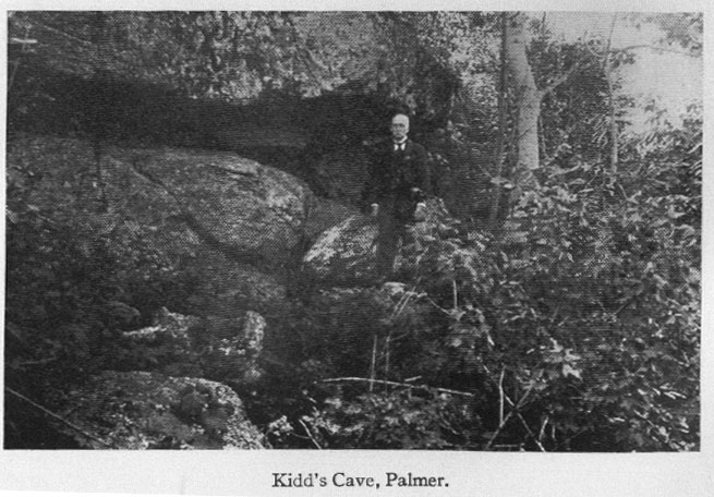
Think you might get lucky and find some more clues where the vial was located? Take a trip to Pataquattic Hill where Rezz has placed a cache nearby where the Shaws located the first stage of this infamous multi-cache.
The History Tour
Now, onto the new cache. Relax in your car, grab a navigator, and let us be your tour guide as we take a trip back in time in Palmer. . . we’ll dole out the history as well as noting nearby caches of interest.
We’ll start the tour at the entrance to the Mass Pike on Route 32. From here, head north on Route 32 towards Ware.
Palmer's first settler was John King, who arrived in 1716. Initially, on account of the numerous bends in the Chicopee, Ware & Quaboag rivers, the plantation was called the "Elbows", "Elbow Plantation" or "Elbow Tract" (see MCTC - Elbow Tract by Aslanspawh). The first legal town meeting took place on August 7, 1733, where a committee was appointed to layout roads in town. In 1748, in honor of the first settler, the plantation was called Kingstown and sometimes Kingsfield. It also bore the name New Marlborough for some time.
In 1752, the plantation petitioned the governor to become officially known as Kingston, however, there was already a Kingston in southeastern Massachusetts. Instead, the town was named Palmer in memory of the deceased cousin (Thomas Palmer) of the then English governor of the Massachusetts Bay Colony.
Waypoint 1 – Old Palmer Center
From the 1730's through the early 1800’s all religious, social, business and government activity was centered in Palmer Center (the intersection of Flynt Street and Route 32). As you approach Flynt street, ahead of you, you can still see the cut where the old road went through Palmer Center and right past the Palmer Center Cemetery, and onward towards Warren. Today, the cemetery is almost a distant, hidden memory. (You'll be parking on this 'road' in a few moments)
The tavern, the meetinghouse, burying ground and country store were all located around the village green. The Center was a busy place especially when the stage to and from Boston made its stop. The first turnpike road (chartered in 1796) built in Massachusetts ran through Palmer Center; it served as the leading thoroughfare for long travel between Boston, Worcester, Springfield, Hartford, New Haven and New York. However with the building of The Thorndike Company Mill in 1837 and the Western Railroad along the southern border of the town in 1839, the center of activity shifted to the new villages leaving Palmer Center to slowly fade in importance.
Head to Palmer Center Cemetery (park at N42 10.959 W072 18.700). The cemetery, which is said to be haunted, is home to some very old gravestones, and as you look around, you'll notice names of many influential Palmer residents. (This cemetery is a stop on the way to completing the Obelisk Puzzle Cache)
Letter A: David Shearer died in 1838, what year was he born? 17_0
Waypoint 2 – Thorndike Mill
Return to Palmer Center and head northwest into Thorndike via High Street (and then Church).
Thorndike Village, located in the valley at the falls on the Ware River, was originally settled by the Ferrells, McElwains and Quintons as early as 1732 (familiar names if you perused the Palmer Center cemetery grounds). From 1736 on, there has always been a mill on the river; first a gristmill, then a sawmill and in 1837 the Thorndike Company Textile Mill. Before Israel Thorndike, John S. Wright and Luther Parks began construction of the Number 1 mill, there were few houses in this valley. However the mill brought prosperity to the hamlet along with jobs for 600 workers.
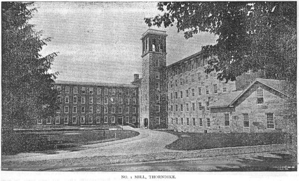
Mill No. 1 in Thorndike
With the construction of the upper mill in 1845 and the many company houses lining Main, Pine and Church Streets, Thorndike became a bustling community with its own school, stores, post office and Temperance Society. (As you pass by River Street, you will notice the Ware River falls off to your right – if you desire a closer look, head up Hill Street.) In 1920, The Thorndike Company built a stairway from Church Street to Hobbs Street for the convenience of the workers who lived in the newly constructed company houses on Hobbs, Harding and Hill Streets.
Letter B: Here there are _8 steps from Church Street to the top.
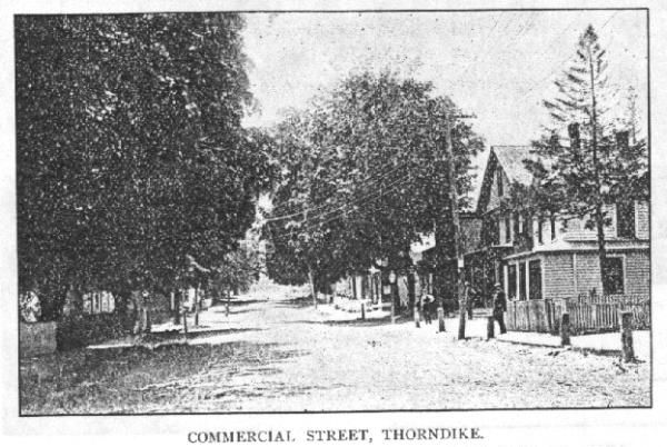
Continuing Northwest on Church Street, notice the Ware River Rail line that runs parallel to Commercial Street, the heart of the Thorndike business district for many years.
Turn left on Main Street, heading west. Looking left as you pass over the Ware River, you'll see one of the spillways on the river.
Waypoint 3 – Thorndike Grammar School
Here you will find the Thorndike Grammar School, built in 1912, long an important educational building in Thorndike. Currently the Grammar School houses the Palmer Head Start and a dance studio.
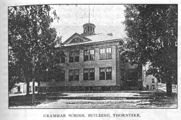
Letter C: Looking north across Main Street from the Grammar School, there is a building with two sets of four numbers. Both sets start with the same two numbers _0.
Return to Church Street, which almost immediately changes names to Pleasant Street. Follow this to Thorndike Street, where you will pass between one of the two sets of bridge abutments left from the defunct Hampden Rail (see The Ghost of the Hampden Rail cache). Turn right onto Route 181 north, and head to the intersection with State Street.
Waypoint 4 – Emelius Bond
Emelius Bond, born in Brimfield in 1800, settled in the northwestern corner of Palmer in 1829 establishing a general store on the corner of Main and State Street. His store was across State street from St. Bartholomew’s Church. Not only did he work to improve the water rights of the Swift River and lay out the streets of the new village, he also gave his name to the hamlet first as Bond’s Village, later as Bondsville.
Bondsville remained a sleepy little hamlet until 1845 when the water privilege on the Swift River was bought by Augustus Fiske, John S. Wright and Elijah Loring. These men formed The Boston Duck Company for the manufacture of cotton duck and woolen goods. Although earlier attempts had been made to harness the waterpower on the river, this was the first successful and lasting attempt. The Company built a 240 x 50 foot stone mill five stories high on the Bondsville side of the Swift River. Soon other buildings followed, as well as numerous houses for the factory workers.
The Boston Duck Company prospered until economic difficulties in the 1940’s forced it to cease operations. In 1942 an auction was held to liquidate all property of the Company including company houses and factory buildings. The complex housed a number of small companies until October 4, 1968 when the entire area was destroyed by fire. (For more information on the history of Bondsville, see Xia Dog and Dingity’s Bondsville Heroes, Old Bell cache. To take a walk through near the ruins of the old textile mill, see There’s Something Fishy About This One)
Letter D: Right near Bond's store, at the intersection of Route 181 and State Street, there is an old horse trough – the date on the now 'flower trough' is 191_.
Head back south on Route 181 towards Three Rivers.
Waypoint 5 – The Bell at Four Corners
Once the population had shifted away from Old Palmer Center, Four Corners became the centralized location of town government. In 1845, the town voted to build a new Town Hall at Four Corners to house the local government. The wooden building stood on the site until 1963 when it was demolished to provide room for the construction of the current Town Administration Building, finished in 1964. The Bell that now rests on the lawn of the Town Hall at Four Corners was originally given to the Town of Palmer by Aaron Merrick in 1803 and placed in the Meetinghouse at Palmer Center. In 1847, the meetinghouse used by the Congregational Church was vacated when the membership voted to split due to economic reasons, with half the members moving to Thorndike to form the First Congregational Church, and the other half to Depot Village to form the Second Congregational Church.
The Palmer Center meetinghouse, which still held the bell, was then rented out from time to time by the town. After the Congregational membership vacated the meetinghouse and prior to its sale to the Bishop of Springfield, a controversy arose as to the rightful home for the bell. The First Congregational Society in Thorndike felt that it should be removed and placed in the belfry of their meetinghouse while the people of Palmer Center were quite happy to have it remain where it was. There were strong feelings on both sides, which soon brought things to a climax. In January 1852 a group of about 40 men, who were attending an evening church social, devised a plan to remove the bell from the steeple and carry it to Thorndike on a sleigh. As they reached the top of Center Street hill they rang the bell in triumph before descending down into Thorndike. The bell was never returned to the meetinghouse, which by that time had been consecrated as St. Anne’s Church. Even though a court order directed that it be returned, it remained in the steeple of the First Congregational Church until it was removed in 1947 for structural reasons.
(Park at the Town Hall for easy access to the bell)
Letter E: Engraved in the granite under the bell is a date: June 1_, 1975.
Turn west onto Main Street towards Three Rivers center.
Immediately on your left will be Saints Peter and Paul Church. The construction of the Church in 1905 reflects the immigration pattern of the early 1900’s during which millions of Poles came to the United States entering through Ellis Island before dispersing across the country. The textile mills in Three Rivers, Thorndike and Bondsville drew many to work and settle in Palmer. The first religious meetings were made up of small groups who met in private homes using lay leaders for religious instruction. As their numbers grew the parishioners united and with the help of St. Stanislaus Lyceum were able to lay the cornerstone of Saints Peter and Paul Church in 1905 at the centralized location of Four Corners. According to the 1905 census, fully 40% of Thorndike residents were Polish.
Continue west towards Three Rivers, crossing over the Quaboag River.
Waypoint 6 – The Three Rivers Manufacturing Company & the Three Rivers Common
The village of Three Rivers was formed in 1825 when a large textile mill was built just below the confluence of the Ware, Quaboag and Chicopee Rivers. The Three Rivers Manufacturing Company, as it was called, would later become the Palmer Mill and would have a dominating influence on the growth of this village for the next 100 years. Trouble with canal construction caused the first company to bankrupt and close. The water rights and mill buildings were bought in 1831 by J. S. Wright.
The Palmer Company flourished in the manufacture of short staple cotton, and soon a bustling village grew around the mill with houses, schools, stores, churches, a hall and numerous company owned tenement buildings. The mill prospered encouraging the owners to expand and build new mills in Thorndike and Bondsville. The first mill buildings burned in 1863 and were not immediately rebuilt due to the uncertainties of the Civil War. The property was sold in 1872 to the Otis Company who constructed a new mill. Many of the company houses on Maple, Front and Kelley Streets including the large brick blocks were built by the Otis Company in the early 1870’s. Another spurt of major construction occurred in the 1920’s during which time a new 5 story mill was built along with 52 tenements. 12 years later in 1933 the mill began selling off its housing; the mill ceased operation in 1936.
In 1860, one acre of ground in front of the Palmer Mill building was developed as a park for public use. This common remains the only surviving common in the Town of Palmer. The Gazebo, which is the centerpiece of the common, is the third one to be constructed in the village. The first was built by the Palmer Mill in 1883 and stood on the left side of the common until 1913 when it was removed to the mill agent’s lot near Baptist Hill Road. The second gazebo was erected in 1927 by the Three Rivers Chamber of Commerce as was the third in 1991. Across from the common, the Three Rivers Grammar School remains a focal point of the area. Built in 1908 the brick building replaced the wooden schoolhouse of 1859.
(
For a little more history of the Three Rivers area, see the MCTC – 3 Rivers cache by Aslanspawh)
Letter F: The memorial to Frank A. Hryniewicz states the date of his death, December 7, 194_.
Head southeast on Park Street, which turns into Palmer Street to Route 181,and turn right (South) onto Route 181.
Waypoint 7 – Shearer’s Corner
Shearer’s Corner (the intersection of Route 20, Route 181 and Shearer street) takes its name from Purlin Shearer, who built his house on the corner of what today is Shearer and North Main Streets. The corner has always been a center of activity as the main road to Springfield and points west. In 1775, General Knox traveled through Palmer with men and munitions to join Washington in Cambridge. A marker was placed on the traffic island at Shearer’s Corner commemorating the event. (and 25 others were placed in Massachusetts along the Knox Trail)
(For a quick cache, before you head out, visit Who Am I? - a puzzle cache located 1/4 mile up Shearer Street)
(Park on the Shearer Street 'extension' west of 181, and make the short walk to the monument)
Letter G: The plaque at Shearer’s Corner honoring General Knox was erected in 192_.
Continue southeast (on Route 20) back to the center of Depot Village. Turn left at the Hess Station (at the stop light) staying on Route 20. At the next light you'll turn right and continue southeast on Route 20
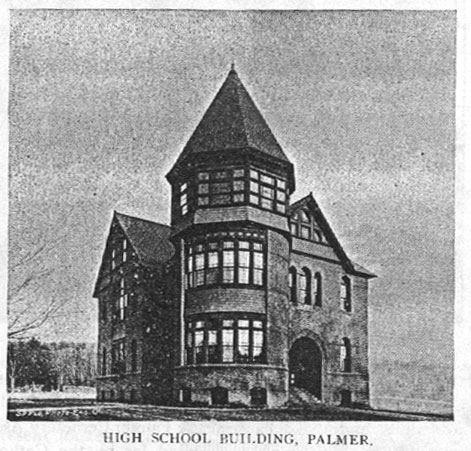
At this 2nd light, note in front of you the brick building with the turret. In 1752, Palmer was divided into 4 school districts. 10 pounds, 14 schillings and 4 pence was granted for the support of the schools for one year. There was one teacher who rotated througout the district. The building here, the Thorndike Street School, was built in 1888, and served as the high school until the Converse school was built in 1925.
Diagonally across route from the Thorndike Street School stands St. Thomas's church. This site is the former location of the 'bear tree' - another of Palmer's legendary folk tales.

On his way to church one Sunday morning (circa 1763), Thomas King spotted a bear in this pine tree. He took it upon himself to shoot the bear. However, he was soon arrested for disturbing the peace on the Lord's Day, a serious offense at that time. King was eventually acquitted on the grounds of self-defense, and that he had killed the bear to protect the many children heading to church that day. However, from that day forward, the pine tree would be known as "The Bear Tree." The tree was forbidden by law to be removed to remind others of the Sabbath Day laws, and so remained until 1941 when the tree was finally cut down due to damage sustained in the hurricane of 1938.
Waypoint 8 – Last Trolley Pole in Town
The Palmer-Monson Trolley line was built in 1898 linking the two towns with a convenient and readily accessible form of public transportation. In 1901, the line was extended through Wilbraham to connect to the Springfield Street Railway. By 1905, the line was extended again connecting Brimfield and later another line was added connecting Ware. Palmer residents were able to travel to neighboring communities for 15 cents.
On a busy weekend, trolleys would run every half hour carrying two cars full of passengers. Trolleys were also used as freight lines to these outlying towns, coal was picked up in the B&A Rail yard and brought to Brimfield early each morning. However, the trolley had a short life span - by 1927, the trolleys had been replaced by local bus services. Some of the trolley tracks have since been paved over while others were pulled up in the 1940’s and used as scrap metal for the War. The lone trolley pole left in Palmer is found here.
Across Park Street from the trolley pole stands what is now called 'Schoolhouse Commons'. This building was the Park Street School, built in 1900 and used as the elementary & middle school for Palmer until the Old Mill Pond School was built.
Letter H: – On the Park Street School building, next to the double doors, you'll find a number: 1_85.
Turn back northwest on Route 20, taking a left at Central Street heading to the main business district in Depot Village.
As you pass Pleasant street, on the left is Memorial Hall. Memorial Hall was built in 1891 and dedicated to the memory of the men who served during the Civil War. The first floor of the building housed The Young Men’s Library Association until 1976 when the new library building on North Main Street was opened. The architect of Memorial Hall was H. R. Robertson, from Springfield (see Waypoint 9)
At the end of Central Street on the North side, Gale’s Newsroom is one of the oldest remaining buildings on Main Street - built in 1849. On that same block once stood the Nassowanno House, one of the 3 hotels in Depot Village during the late 1800’s as well as a second hotel, the Converse House.
The Nassowanno House (foreground) and the Converse House
Along with the Weeks House on South Main Street, these hotels enjoyed great success catering to the many travelers who came by way of the railroad. The lot where the Nassowanno House once stood now houses a gazebo/bandstand in a small park with a wooden train (tested and approved by Alexa).
Turn left here onto South Main, cross the railroad tracks and take an immediate right onto Depot Street.
Waypoint 9 – Union Station (Palmer Railroad Station)
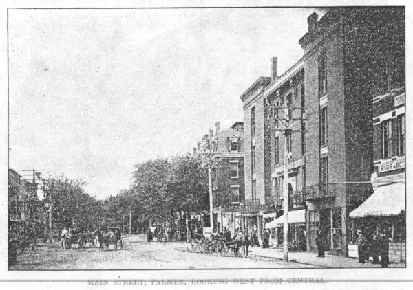
We arrive back near the center of Depot Village – the main hub of business and commerce in town since 1839. Here the work of Henry Hobson Richardson looms large. Richardson is the architect who designed the Palmer Railroad Station for the Boston and Albany Railroad. His major works included the designs for the Trinity Church in Boston, Harvard’s Sever Hall and the Harvard Law School; The New York State Capitol in Albany, Albany City Hall and the Hampden County Court House in Springfield.
In planning the station for Palmer, Richardson was challenged to design a building that would serve both the New London Northern Railroad and the Boston and Albany replacing the two existing stations. The result was a unique trapezoidal design placed in the triangular area formed by the crossing of the lines. The roof is the chief feature of the station even today though the long passenger sheds have been removed. Union Station, built by the Flynt Construction Company at a cost of $53,616, was opened to the public on June 1, 1884. To give an idea of the building’s extravagance, Thorndike Street School was built as Palmer’s first High School in 1888 for only $5,000.
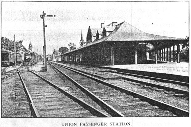
Grab a bite to eat at the newly refurbished depot, now a restaurant called the Steaming Tender – a very nice spot to eat, and a great place for railfans to watch all of the action on the lines. (for a little more history on the Elbow Tract (one of Palmer's original monnikers), see Aslanpawh’s MCTC – Elbow Tract cache)
Letter I: There is a sign near the rail line on the north side of Depot Street. The sign says "Railroad Crossing: Look out for the _____" Letter I is the # of letters in the missing word.
Return to South Main turning north, and continuing west on Route 20.
Waypoint 10 – George Washington Was Here!
George Washington made two confirmed stops in Palmer. On June 30, 1775 General Washington and his escorts stopped beneath the large elm tree near K-Mart Plaza for rest and refreshment. The latter was supplied by the innkeeper of Graves Tavern on the other side of the road. The second visit came on October 22, 1789 soon after Washington was sworn in as President of the United States. Once again on his way to Boston, he spent the night in Springfield. According to his diary he and his staff left Springfield at 7AM, stopping in Palmer at Scott’s Tavern, located near Shearer's Corner. The Elm, which stood 100 feet tall with a 15-foot circumference, has ever since been known as the Washington Elm. In 1906 a marker was placed by the Historical Society commemorating the Washington visit. In 1975, the diseased and damaged tree was removed.
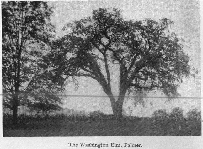
Letter J: There is a plaque here commemorating George Washington’s visit. The plaque was erected on June _0, 1906.
And thus ends the tour of Palmer! You have all of the information needed to find the physical cache - it's not far now!
The Physical Cache
The cache can be found by using the information you acquired: If you have calculated the final cache location correctly, the area should look familiar when you arrive to park.
The cache is a .30 cal. ammo can with a special prize for the FTF, along with an assortment of other goodies. The cache is stuffed, so please take something! As usual, lead cache designer Alexa took care of the paint job.
The waypoints are listed in the table below, and are available in gpx format here
The table in PDF format is availble here
| WP |
Letter |
Number |
Latitude |
Longitude |
Information Required |
| 1 |
A |
|
N42 10.907 |
W72 18.724 |
David Shearer was born in 17_0 |
| 2 |
B |
|
N42 11.254 |
W72 19.664 |
Number of steps leading to Hobbs Street: _8. |
| 3 |
C |
|
N42 11.408 |
W72 20.050 |
Across main street: two sets of four digit numbers start with _0. |
| 4 |
D |
|
N42 12.638 |
W72 20.739 |
The horse trough is dated 191_. |
| 5 |
E |
|
N42 11.161 |
W72 20.869 |
The date listed under the bell is June 1_, 1975. |
| 6 |
F |
|
N42 10.713 |
W72 22.012 |
Frank A. Hryniewicz died December 7, 194_ |
| 7 |
G |
|
N42 09.799 |
W72 20.615 |
The Knox memorial was erected in 192_. |
| 8 |
H |
|
N42 09.368 |
W72 19.476 |
On the Park Street School building (next to the double doors) is the number 1_85. |
| 9 |
I |
|
N42 09.344 |
W72 19.719 |
The sign says: "Railroad Crossing: Look out for the _____" # of letters in the missing word. |
| 10 |
J |
|
N42 09.655 |
W72 21.304 |
The plaque commemorating Washington's visit was erected on June _0, 1906. |
| N 42 |
(E-C) |
H |
. |
(C+E) |
(C+D) |
(F+G) |
| N 42 |
|
|
. |
|
|
|
| W 72 |
(J-D) |
(J+E) |
. |
(I-G) |
(A+J) |
(D+G) |
| W 72 |
|
|
. |
|
|
|
Final Notes
Much of the historical information and narrative was collected from the Town of Palmer's website (currently down for rennovations). Also used for reference and photographs were the books Pictorial Palmer, published in 1896 by Carpenter & Cady, and The Old Post Road by Stewart Hall, Holbrook (1962).
Jacob Knight's historical folk art painting was to be completed for the town's 275th Founder's Day Celebration in 1991, however, what was originally to take 18 months actually took 4 years to finish (the narrative mentioned earlier was written for this painting). The painting measures 5' x 7' and is on exhibit in the Community Room at the Palmer Library - well worth a visit to see this history on display.
Special thanks to XiaDog for helping with the local history and proof reading of the cache page.
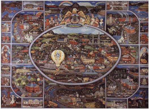
Jacob Knight's 'Palmer Folk Art Painting'
You can check your answers for this puzzle on GeoChecker.com.