
In ancient times passage to the other side of the Ourthe was a difficult enterprise. In Maboge in between "le Moulin" at one side and "Ry de Hubermont" on the other side a wooden bridge was made to cross the river during summertime as in wintertime the bridge had to be dismanteld for the rising water.
One of the local merchants lost part of his cargo at this cache-site when adoring the beautiful view.
Try to help him out.
You can park your car at the starting coordinates at N 50° 10.088 E 5° 37.704
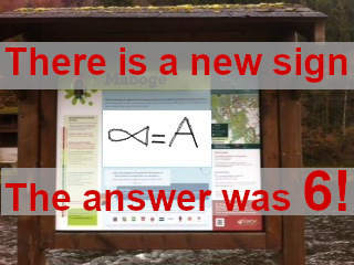
Count the fishes = A
Then calculate the next coordinates:
N 50° 10.0 ( 8 * A )
E 05° 37. ( 112 * A )

Simply find the "Dymo-Label" very close to the place on this photo. This will help you to calculate the next station:
N 50° 10. ( 10 * B + 14 )
E 05° 37. ( 40 * B + 18 )
Backup! If the the label is gone, you can count the number of the letters (X) of a colored sign.
X*2 = B

The altitude is = C
Now you can calculate the final-Coordinates:
N 50° 10. ( A + B + C +33 )
E 05° 38.00A )
I hided this cache on vacation. Cache maintenance is available every few month by an local "house-owner" ;-)
Have fun with this...
Specialy Greetings to paveric