To claim this cache:
- a) go to the posted coordinates and read the sign. The information on the sign is incorrect!
- b) tell us in an email what the sign says and explain what that "means" Jeptha Knob is NOT one of "those things" as this cache page explains.
- c) You may also wish to take a photo with Jeptha Knob in the background-- or something related to the area (see previous posts for lots of fun examples).You are welcome to be in the photo, but it's not required.
Alternately, you can become a part of the ongoing study of the area! Locate any of the nearby rock outcrops and see if you can locate brecciated rocks, or photograph examples of faulting and folding. Send us the coordinates where you located your find and explain what you learned at that stop. This cache page can help you learn about those kind of features.
Be careful to stop only where safe pull-offs exist and do not enter private land without permission!
We would welcome other photos of Jeptha Knob, but please do not post a photo of the sign. One great photo opportunity can be found at:
N 38 11.018 W 85 05.415

Jeptha Knob is physically located at:
N38° 10.748 W 085° 06.77 The top of the Knob is a restricted area because of the antenna farm.
Located in the Bluegrass region of Kentucky, Jeptha Knob hides a meteor impact crater that has been eroded, buried, exposed, and is now undergoing even further erosion. The meteor struck shallow marine carbonates formed in the Middle to Late Ordovician period. The three mile wide crater formed by the meteor impact was exposed to normal weathering until the Early Silurian period, when the trangression of a shallow ocean resulted in the formation of a new layer of limestone (the Brassfield Formation), burying the crater. 350 million years later, the site is again exposed to the elements and a second cycle of erosion continues to reshape the area.

Google aerial image of Jeptha Knob.
Although Jeptha Knob has eroded an additional 220-320 feet below the Ordovician-Silurian contact, it remains the highest point in the Louisville metro area at 1,188 Feet (362 M) above sea level.

Image showing the subsurface map of Jeptha Knob
This image shows the physiographic regions of Kentucky. 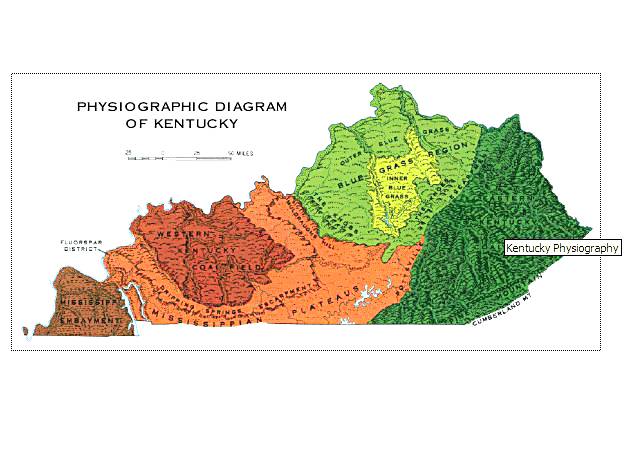
And this one shows the generalized ages of rocks exposed in Kentucky 
When meteors hit the Earth, the impact causes the materials nearby to melt, and to splatter in a circular cone around the impact. When meteors hit the kinds of rocks that existed here, some rocks vaporize in the steam produced while others become brittle and shatter. The shattered rocks show up as chunks of rocks in the melted matrix that flows around them and then hardens.

These rock types, along with the faulting and folding found nearby prove Jeptha Knob is an astrobleme.

Still other types of rocks form "shatter cones"

Note: to date, shatter cones have not been found near Jeptha Knob. Finding some would be a newsworthy discovery!

www.uky.edu/KGS/education/meteorites.htm gsa.confex.com/gsa/2003SC/finalprogram/abstract_49944.htm www.emporia.edu/earthsci/student/jung1/jeptha_knob.htm