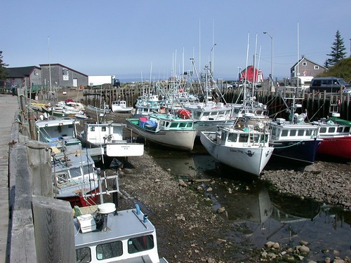
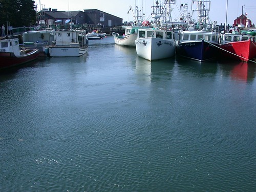
At low tide you will see fishing boats sitting on the ocean floor

Miraculously six hours later the same boats are floating at the top
of the wharf.

Tides are the periodic rise and fall of the sea caused by the
gravitational pull of the moon and the sun on the Earth. Fundy's
tides are the highest in the world because of an unusual
combination of factors: resonance and the shape of the bay. The
water in the Bay of Fundy has a natural resonance or rocking motion
called seiche.
You could compare this to the movement of water in a bathtub.
Although the water in a bathtub sloshes from one end to the other
and back again in a few seconds, it takes about 13 hours for the
water in the bay to rock from the mouth of the bay to the head of
the bay and back again. As the ocean tide rises and floods into the
bay every 12 hours and 25 minutes, it reinforces the rocking
motion.
To imagine this, picture an adult giving a gentle push to a
child on a swing. Just a very small push is required to keep the
swing moving. Likewise the seiche in the bay is sustained by the
natural resonance of the ocean tides.
The bay's shape and bottom topography are secondary factors
contributing to Fundy's high tides. The bay becomes narrower and
shallower [from 130 m (426 ft) to 40 metres (131 ft)] toward the
upper bay, forcing the water higher up onto the shores.The Bay of
Fundy's shape and prevailing ocean currents conspire to create the
highest tides in the world.
Experience what happens as 3,680 billion cubic feet of water
pour in and out of the "funnel" not once but twice each day: Boats
and even ocean-going ships stranded high and dry. Vast tidal flats
waiting to be explored. The water goes out so far that you have to
look for it. This ebb and flow generates enough power to meet all
the world's power needs, if only it were harnessed.
For this cache, you will now need to submit a TOTAL of TWO (2)
pictures (with your GPS in the picture), to log this cache. You
need to indicate "when" these pictures were taken (time) and TOTAL
amount of time, between BOTH pictures