Karst Topography
Karst topography is a landscape feature characteristic of highly
soluble bedrocks (such as limestone) and evaporite deposits (such
as gypsum and anhydrite). In the Carboniferous Lowlands, gypsum
underwent erosion during the Tertiary and planation during
glaciation. Glacial tills covered much of the eroded gypsum, but
sinkholes and disappearing streams reveal the presence of ancient
karst topography. Karst features are very visible wherever gypsum
is mined, and where streams and rivers have removed surficial
sediments to expose gypsum.
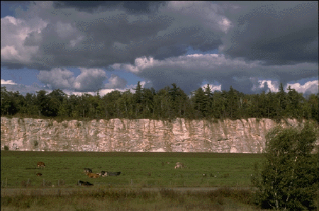
Example, at St. Croix,
where erosion on the bluff has revealed the
gypsum.

Karst surface conditions are characterized by conspicuously
pitted topography. This uneven surface impedes forestry and has
contributed to the fact that some very old coniferous forests still
grow at places like Dutch Settlement and Hayes Cave. Flora and
fauna associated with karst is characterized by calcium-loving
plants and various species of land snail. The Hayes Cave site at
South Maitland has several typical karst features, such as the cave
itself, sinkholes and a collapsed cave system.
Groundwater solution contributed to the erosion of the gypsum,
creating sinkholes. The ancient stream channels and sinkholes were
subsequently infilled and have been preserved as solution-collapse
and cavity- fill structures.
To claim
the earthcache you must send me the answers 4
questions.
Question #1 What is the Chemical formula for Gypsum?
Question #2 When was Gypsum frist mined in Nova Scotia?
Question #3 How many Tonnes of gypsum was mined in 1990 by
Domtar Gypsum Co.?
Question #4 What is the estimated height of the cliffs?
Please take
a picture of you or gps with cliffs in the background to prove you
where there.