HEAD-SMASHED-IN
BUFFALO
JUMP EARTHCACHE
Nestled in the Rocky Mountain Foothills lies
one of the more interesting geographical and historical features of
Western Canada, Head-Smashed-In Buffalo Jump. Where the
prairie meets the foothills, there is a cliff that the natives had
used for many, many years to hunt the buffalo for food. At
the site there is an interpretive centre, some paths, and some of
the most stunning scenery the prairies have to offer.
THIS EARTHCACHE IS BEING HOSTED BY THE
WONDERFUL STAFF OF HEAD-SMASHED-IN BUFFALO
JUMP. PLEASE SHOW THEM THE RESPECT THEY DESERVE BY STAYING
ON THE CLEARLY DEFINED PATHS, AND OBEYING THE RULES.
HISTORY
More than 5,500 years ago, the natives in this
area used the cliffs to their advantage during the large buffalo
hunts. Many of the native communities would come together and
camp in the plains below the cliff while they prepared for the
jump. The general idea was to herd the buffalo into “drive
lanes”. These lanes were marked by cairns of rocks, and
during the run, were manned by the natives in order to direct the
herd. When the buffalo crested the small hill at the top, it
was too late for them to stop before plummeting off the cliff.
‘In the 1800’s, according to legend, a
young brave wanted to watch the plunge of buffalo as his people
drove them to their deaths over the cliffs. Standing under
the shelter of a ledge, he watched the great beasts fall past
him. The hunt was unusually good that day. As the
bodies mounted, he became trapped between the animals and the
cliff. When his people came to do the butchering, they found
him with his skull crushed by the weight of the buffalo
carcasses. Thus, they named the place
“Head-Smashed-In.”’
[source: Unesco
World Heritage Site sign at the location]
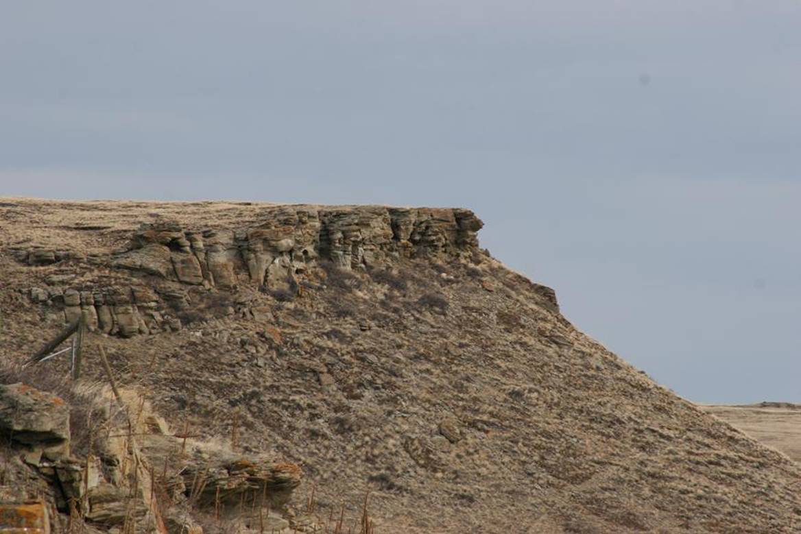
This is a view of the Calderwood Buffalo Jump,
which is beside Head-Smashed-In. From this photo, one can see
that the cliff doesn’t need to be particularly high, just placed
correctly.
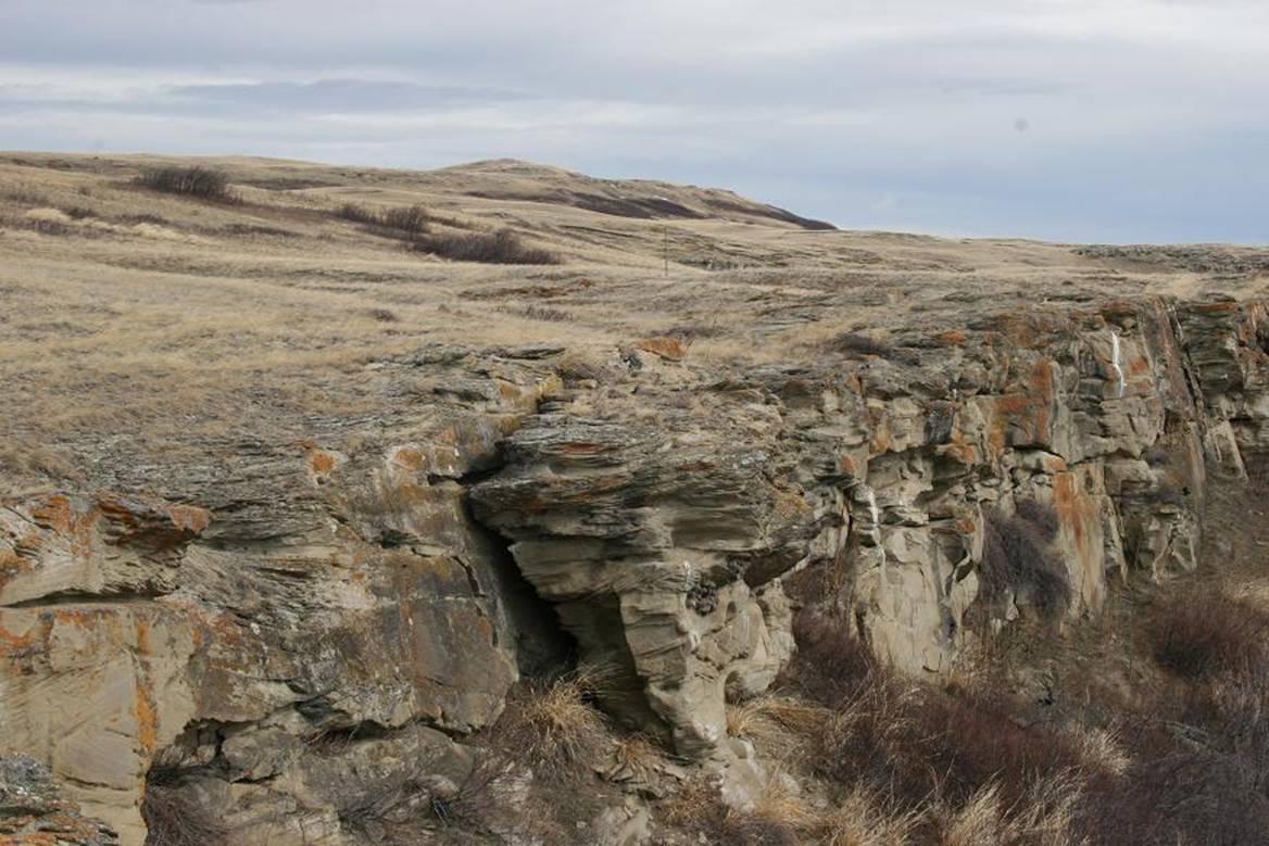
This is a photo taken from the upper path of
Head-Smashed-In. One can see in this photo that the slight
rise on the left provided the appropriate blind for the buffalo to
avoid seeing the cliff ahead. The cliff is only about 10
meters high, but when the natives started using this site, it is
estimated that the cliff was more than twice that height, at about
22 meters.
Question for bonus points: why would the
cliff be shorter now than 5,500 years ago? What makes up this
mass at the base?
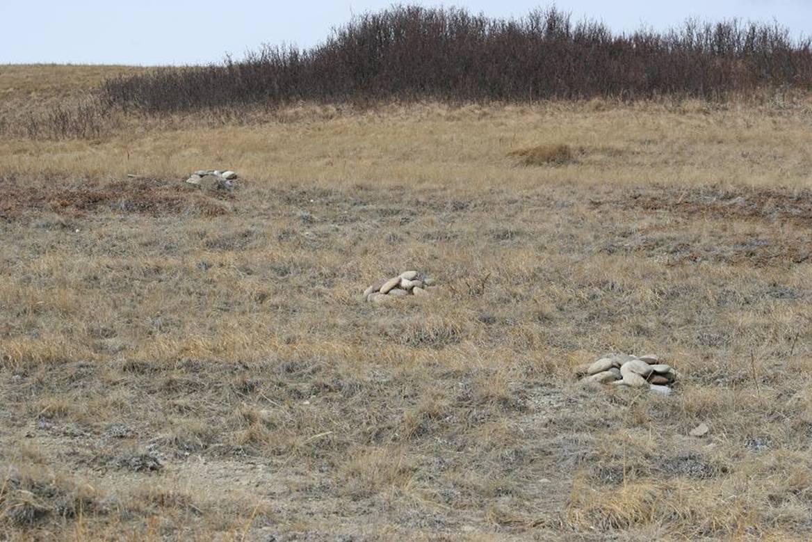
These are replicas of the cairns that marked
the drivelanes as one approaches the jump. These cairns would
have been built up before the drive, and covered with organic
material.
FORMATION
‘To the west of Head-Smashed-In, the
Porcupine Hills surround a large basin of low, rolling grasslands
drained by Olsen Creek and its tributaries. East of this
basin the hills end at deep sandstone cliffs, such as the one at
Head-Smashed-In. Flat plains stretch eastward below these
cliffs as far as the eye can see.
Many similar bedrock outcrops – the eroded
easternmost slopes of the Porcupine Hills – border the Plains near
Head-Smashed-In. Erosion by wind and water has formed the
cliffs by splitting away sections of the sandstone. The
toppled boulders can be seen at the base of the Head-Smashed-In
cliff.
The Rocky Mountains are
folded and fractured beds of sedimentary and metamorphic rocks
which began uplifting some 100 million years ago.
The Porcupine Hills, unlike the
Rockies, are flat beds of sandstone. This accounts
for the level surface at the top of the cliff at
Head-Smashed-In.’
[source: sign
inside the Head-Smashed-In Buffalo Jump interpretive
centre.]
Please note, however, that this does not
answer the bonus points question above.
With regards to the wind through this area, it
is one of the most windy places in Canada. West winds blow
here more than half the time, with some gusts up to 150 kilometers
per hour. This area benefits during the winter from the most
“Chinook” winds (warm westerly winds that can raise the temperature
by as much as 20 degrees Celsius in a few hours), with an average
of 35 Chinooks per year. It is only calm in this area 14% of
the time.
TO LOG THE CACHE
#1) Go to the posted coordinates and examine
the column. There is a specific reason that Head-Smashed-In
is of vital importance to the Province of Alberta. What is
this reason? Email the owner with the answer, or
unfortunately, your log will be removed as being incomplete.
#2) The people at the interpretive centre have
been kind enough to host a logbook for us! Go in to the front
desk, and ask for the geocaching logbook. There is even an
FTF prize!
#3) If you wish to tour the upper trail and
interpretive centre, the current (2007 season) prices and hours
are:
·
Summer: 09:00 – 18:00
·
Winter: 10:00 – 17:00
·
Open year round, every day, except for Christmas Eve, Christmas
Day, New Year’s Day, and Easter Sunday
·
Adults: $9.00
·
Seniors: $8.00
·
Youth 7-17: $5.00
·
Family: $22.00
·
Under 7: Free
#4) Please do log online with photos and
stories of your visit.
The telephone number of the centre is (403)
553-2731.

All photos taken
by the cache owner, 2007.
This earthcache was made possible with the help and cooperation
of the following people, so please be sure to thank them in your
log:
·
The Piikani First Nation
·
Ian Clarke, Regional Manager, Historic Sites and Museums
Branch, Alberta Provincial Government
·
Jim Martin, Manager, Education and Special Exhibits,
Head-Smashed-In Interpretive Centre
·
Tricia, the fine lady at the front desk