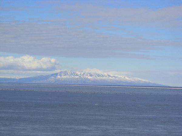
Most of us look at the 4000 foot Mt Susitna as just another
pretty mountain but The Sleeping Lady has a geological story to
tell. Mt Susitna is known as a roche moutonnée.
In glaciology, roche moutonnée is a rock formation created by
the passing of a glacier. When a glacier erodes down to bedrock, it
can form tear-drop shaped hills that taper in the direction of
flow.
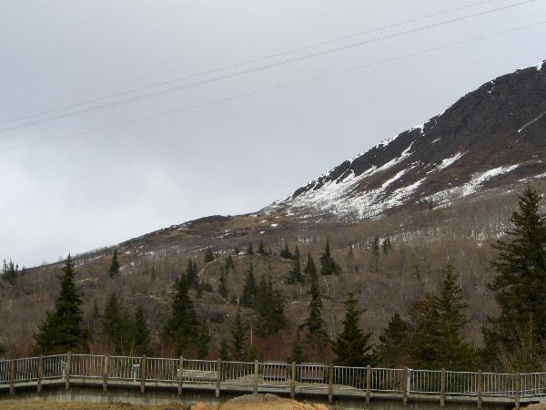
The appearance of the rock formation is well defined: a
formation where all the sides and edges have been smoothed and
eroded in the direction the glacier was moving, with the exception
of the rough and craggy far side. It is this side that has been
subjected to "plucking", the erosional process in which ice melts
slightly by pressure and seeps into cracks in the rock. When the
water freezes, the rock is attached to the glacier and eventually
ripped away from the landform as the glacier continues its forward
progress. It is also subjected to frost shattering. They are
sometimes described as having a teardrop shape with a gradual
incline and a sharp dropoff.
The term "roche moutonnée" comes from the French for "fleecy
rock", despite its popular misinterpretation as "rock sheep". They
are often marked with glacial striations or grooves.

The Anchorage bowl topography has been influenced by 5-7
glaciations. Over several thousand years, thick ice sheets from the
Talkeetna, Chugach and Alaska Ranges flowed down Cook Inlet. The
five well documented glaciations from oldest to most recent were
the Mt Susitna, Caribou Hills, Eklutna, Knik and Naptowne. The
earliest glaciation in the Anchorage area is known as the Mount
Susitna for the erratics and other glacial features found on the
top of Mount Susitna. This is the time period when it obtained its
characteristic streamlined shape. It is dated to the late Pliocene
to the early Pleistocene (2-6 million years ago).
There are other examples of roche moutonnée in the Anchorage
area at McHugh Creek State Park. Near Palmer, Bodenburg Butte is
another example.

This is an EarthCache - without
container or logbook - where you'll observe, document through
measurements and photographs, and report your findings via email to
earn credit for this cache. Logs which do not conform to these
requirements will be deleted, as this cache requires a demonstrated
acquisition of knowledge about the geologic forces at work. Read
all the requirements for completing this cache before you visit the
area, and equip yourself with the necessary tools (including a
camera). To demonstrate your acquisition of knowledge about Mt.
Susitna as a Roche Moutonnee, please answer these questions briefly
in an email to me through the geocaching.com website.
Post a photo in your log of yourself with
Mt. Susitna in the background,
but don't post your answers in your log.
Report in the online log how many were in your party during your
visit. Logs not conforming
to these requirements will be
deleted.
1. How thick do you think the ice was that covered the Anchorage
bowl during the Mount Susitna glaciation?
2. Do you think the other glaciations were as thick? Why or why
not?
3. Which direction was the glacier traveling that created Mt
Susitna? What evidence suggests this?
4. Would you be able to identify a roche moutonnee from the
information provided here?
The above information was compiled
from the following sources:
Cathy Connor & Daniel O'Haire,
"Roadside Geology of Alaska," 1988 Missoula, MT,
L.M. Dilley & T. Dilley, "Guidebook to Geology of Anchorage,
Alaska", 2000 (1st edition) Anchorage, AK
http://EN.wikipedia.org/wiki/Roche_moutonnee
http://www.fettes.com/cairngorms/roche%20moutonnees.htm
Read the Dena'ina
Legend of Mt Susitna (Scroll down)
A live webcam view of Mt Susitna.
Congratulations to NorthWes on his First To
Learn (FTF)!!
The Geological Society of America (GSA)
EarthCache Project - Learn about the EarthCache Master Program:
earn Bronze / Silver / Gold / Platinum status, with an EarthCache
Master Pin awarded at each level!
