Alaska abounds in geological puzzles. Many geologists from all over
the world have studied the various terranes, faults, glaciers and
other geologic features in the State. Have you ever traveled the
Seward or Glenn Highways and wondered why things look as they do?
EarthCaches attempt to explain the geology of our State so that we
may better understand the world around us. We hope this EarthCache
meets that goal.
This is an EarthCache - without
container or logbook - where you'll observe, document through
measurements and photographs or other means and report your
findings, via email, to earn credit for this cache. Logs which do
not conform to these requirements will be deleted, as this cache
requires a demonstrated acquisition of knowledge about the geologic
forces at work. Read all the requirements for
completing this cache before you visit the fault area, and equip
yourself with the necessary tools (including a camera).
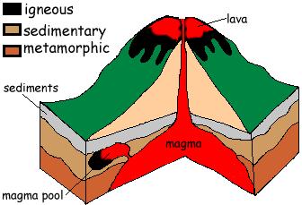
All rocks fall into three classes which are named according to
their origin: igneous rocks, sedimentary rocks, and metamorphic
rocks.
Igneous rocks are called fire rocks and are
formed either underground or above ground. Underground, they are
formed when the melted rock, called magma, deep within the Earth
becomes trapped in small pockets. As these pockets of magma cool
slowly underground, the magma becomes igneous rocks. Igneous
rocks are also formed when volcanoes erupt, causing the magma to
rise above the earth's surface. When magma appears above the
earth, it is called lava. Igneous rocks are formed as the lava
cools above ground. Examples of igneous rock are granite,
scoria, pumice and obsidian.
Sedimentary rock - For thousands, even millions of
years, little pieces of our earth have been eroded--broken down and
worn away by wind and water. These little bits of our earth are
washed downstream where they settle to the bottom of the rivers,
lakes, and oceans. Layer after layer of eroded earth is deposited
on top of each. These layers are pressed down more and more through
time, until the bottom layers slowly turn into rock. Examples of
sedimentary rock are sandstone, limestone, shale, conglomerate and
gypsum.
Metamorphic rocks are rocks that have "morphed" into
another kind of rock. These rocks were once igneous or sedimentary
rocks. How do sedimentary and igneous rocks change? The rocks are
under tons and tons of pressure, which fosters heat build up, and
this causes them to change. If you examine metamorphic rock samples
closely, you'll discover how flattened some of the grains in the
rock are. Examples are schist and gneiss.
The coordinates take you to a slate outcrop of the Valdez Group
(see CG12914). (Also note the adjacent benchmark.)
Parking is available within 200 feet on the
right side of the road as you are driving South. Please be
careful crossing the highway and while examining the
terrain! The rock across from parking all the way to
the listed coordinates is metamorphic rock. The protolith (the
unmetamorphosed rock from which a metamorphic rock was formed)
was shale which was formed by mud deposited in a quiet, deep sea
environment. Shale and mudstone are the most common sedimentary
rock because they come from the most common environment, a deep
marine environment.
The shale was slightly metamorphosed to produce the slate. If
slate becomes slightly more metamorphosed it turns into rock called
phyllite. If still more metamorphism occurs,
schists are formed. The agent for metamorphism
for regional events like this is pressure, with low temperature
variations associated with subduction zones, terrane collisions
and mountain building.
Shales are normally deposited flat. Foliations are fractures
along mineral planes in the rock. Foliations usually follow the
angle of deposition, (deposition is material (like sediment) being
added to a landform) which is typically flat to slightly angled for
shale.
As you walk to the right and left, observe the outcrop
composition and orientation.
To demonstrate your acquisition of knowledge
of this outcrop, please answer these questions briefly in an email
to me through the geocaching.com website. Post a photo in your
log of yourself at the formation, but don't post your answers
in your log. Report in the online log how many were in your party
during your visit. Logs not conforming
to these requirements will be deleted.
1. Describe the orientation angle of the shale in the
outcropping immediately below the benchmark at N60 59.033 W149
31.995 (i.e. vertical, 30 degree angle to vertical, etc).
2. Moving just dozens of feet east along the outcropping, describe
how the shale's orientation changes relative to the area
immediately below the benchmark.
3. What geologic forces may be responsible for the shift in
orientation of the shale? (fault slip, mountain building, caused by
subduction, displacement by earthquake-generated movement)
4. What historically recent local event may have altered landforms
along Turnagain Arm, and how?
The above information was compiled
from the following sources:
L.M. Dilley & T. Dilley, "Guidebook
to Geology of Anchorage, Alaska", 2000 (1st edition) Anchorage,
AK
http://www.fi.edu/fellows/fellow1/oct98/create/index.html
http://seis.natsci.csulb.edu/bperry/ROCKS.htm
Cathy Connor & Daniel O'Haire,
"Roadside Geology of Alaska," 1988 Missoula, MT
Timothy M Kusky, Dwight C Bradley and
Peter Haeussler, "Progressive Deformation of the Chugach
accretionary complex, Alaska, during a paleogene ridge-trench
encounter" 1995 Anchorage, AK
Susan M Karl, Nancy R Vaughn, Timothy
J. Ryherd, Ed., "1997 Guide to the Geology of the Kenai Peninsula,
Alaska, 1997 Anchorage, AK
Susan Bartsch-Winkler and Henry
Schmoll, "Guide to Late Pleistocene and Holocene Deposits of
Turnagain Arm",1984 Anchorage, AK,/font>
Dwight Bradley and Marti Miller, "Field
Guide to South-Central Alaska's Accretionary Complex, Anchorage to
Seward, 2006 Anchorage, AK
The Geological Society of America (GSA)
EarthCache Project - Learn about the EarthCache Master Program:
earn Bronze / Silver / Gold / Platinum status, with an EarthCache
Master Pin awarded at each level!
