Phase 3: The Invasion of Long Island
The Revolutionary War in New York in 1776
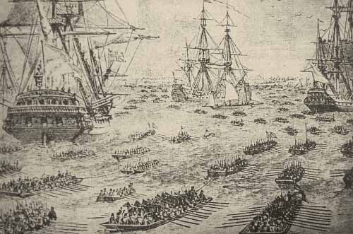
British Forces Prepare to Land in Brooklyn
* * * * *
These are the times that try men's souls. The summer soldier and the sunshine patriot will, in this crisis, shrink from the service of their country; but he that stands by it now, deserves the love and thanks of man and woman.
...from The Crisis by Thomas Paine, 1776
* * * * *
Phase 3 begins the British invasion from Staten Island to subdue the rebels and takes us through lower Brooklyn and into Prospect Park where the cache container is hidden. Phase 4 container is hidden in Prospect too if you're planning to do a few Phases on the same day.
It was on August 22nd, 1776 when British Admiral Howe began to move. Rather than face Washington’s artillery at the Manhattan Battery, Howe smartly navigated over 400 vessels including frigates, flatboats, bateaux, galleys and other boats across the Narrows at New York Bay where the Verrazano Bridge now stands, to land in Gravesend. Vessels were filled with German and English troops. Some of the English companies included the 17th Light Dragoons and the Black Watch Brigade ( A Scottish brigade with Black Kilts). 15,000 men landed on Brooklyn from Staten Island, along with Commanders Clinton, Cornwallis and the Hessian (German) Count von Donop. The 200 Pennsylvania riflemen in the area were no match for the British army and quickly withdrew.
Washington quickly reinforced Brooklyn by ferrying by row boat more troops to the Brooklyn side of the East River. On the 25th of August, after 3 days, winds shifted further in Washington's favor and Howe was unable to add more troops to Brooklyn's south shore. But by the 26th Howe was able to move the many German Troops to the theater of the Brooklyn War. Washington had split his Army in two, half of the Continental Army in Brooklyn, its back to the East River and vulnerable to naval assault, and half in New York City, with its cannons facing the wrong direction.
In Boston the English made the mistake of underestimating the rebels and marched their columns directly in front of fortified American positions on Breed Hill. In Brooklyn, Howe was not going to make the same mistake. The terrain of Brooklyn is such that a large hill runs down the center of its spine forming the terminal moraine where the Ice Age glaciers stopped their southern movement thousands of years ago. The spine runs up Sunset Park, Greenwood Cemetery through Prospect Park and Lookout Hill, Mount Prospect behind the Brooklyn Museum, and out along Eastern Parkway and through Forest Park in Queens. Washington fortified the hill tops and the southern slopes in Red Hook and Flatbush. 10,000 British troops simply marched around the American fortifications in a flanking maneuver.
After camping for 5 days in Flatbush, they marched east on what was called Jamaica Pass, which ran approximately along present day Empire Blvd., and was unguarded by the Americans. Unopposed they marched into New Lots and Brownsville. They stopped for drinks (yup - drinks) at a tavern called the Rising Sun Tavern and forced the tavern owner to show them a northern passage called Rockaway Path in today's Evergreen Cemetery, north to what today is the Eastern Parkway area, to the township of Bedford.
The British then headed through Jamaica pass and flanked westwards in a surprised attack on the American forces defending their position southwards in what is now Prospect Park where our cache container for Phase 3 is hidden.
About the 1776 cache series:This series of caches take you through the political intrigues and armed battles in the city of New York during the Revolutionary War in 1776. Each cache Phase consists of a tour of the local area’s Revolutionary sites. You will gather clues that will provide the coordinates for the cache container for that Phase. Containers will vary from ammo cans, plastic containers and magnetic micros limited by the locale – woods, parks and urban street. The larger containers will have memorabilia such as replicas of revolutionary coins, paper money, musket balls, Declaration of Independence on parchment, etc. as well as more traditional cache treasure. Please take one memento only and leave the rest for other cachers. Leave something if you take something but don't stuff the smaller containers.
Click on the bookmark on the upper right side for a list of all 1776 cache phases. Each stands on it’s own. You do not have to follow any particular order although doing so gives a better prospective of the action. Cachers logging finds in all 8 phases will have their names added to the Cacher's Honor Roll in the Phase 8 cache web page. Campaign maps in the photo section provide orientation for each Phase and for the whole City. However, these are not needed to do the cache.
The caches follow much of this companion tour guide and book. For those traveling on foot, it provides public transportation methods for getting around. However, they are not required to find the cache.THE BATTLE FOR NEW YORK: The City at the Heart of the American Revolution by Barnet Schecter.
Start your Phase 3 tour at The Cannon at Fort Hamilton Park. The tour runs about 15 miles by car and a short walking hike to the cache.
A. The Cannon at Fort Hamilton Park N 40 36.693 W 074 02.068
You are now looking out at the Narrows and up at the bridge. (If the morning is misty the bridge may be completely obscured even though it is very close, giving a dramatic impression of the fog that helped Washington during the retreat from Long Island after the Battle of Brooklyn). Deny's Ferry once stood where the bridge meets the shore. This was the stone building that British Admiral Collier targeted with the guns of the Rainbow, during the landing, while he also took aim at the shore road in case the rebels arrived to contest the invasion. Around noon the mist lifts and the bridge becomes visible, as does Staten Island. Tugs and tankers ply the Narrows and provide a sense of scale. It becomes easier to imagine the British ships crossing over to a shore that wasn’t obstructed by roadways and ramps or wrapped in the steady hum of traffic.
The Cannon at Fort Hamilton Park quiz- How many cannon balls are located in front of the cannon?
1. 7 cannon balls.
2. 8 cannon balls
3. 9 cannon balls
ENTER A answer (1, 2 or 3) = ________
Nearby Fort Hamilton are Gravesend Bay and Dyker Beach Park, the landing sites of the British. From there, the British encampments extended eastward--through the townships of New Utrecht, Gravesend, Flatbush and Flatlands--to the marshes at the edge of Jamaica Bay. We’ll travel through some of these areas.
B. Liberty Pole N40 36.512 W74 00.049
You are now in the center of the Dutch village of New Utrecht, established in 1657 on land purchased from the Canarsie and Nyack natives. Today the neighborhood is better known as Bensonhurst. You’re at the New Utrecht Reformed Church at this intersection. The American flag on the lawn marks the spot of a Liberty Pole installed on Evacuation Day at the end of the war when the British gave up and left — November 25, 1783. Many such flagpoles were installed throughout the city on that day. This one, however, is the sixth in an uninterrupted succession on this site—making it the only Liberty Pole in continuous use since the Revolution. The existing New Utrecht Reformed Church is constructed from the stones of the original building. The original church, built in 1700, was located two blocks away, at 16th Avenue, where the original cemetery still stands. The earliest grave dates back to 1654. General Nathaniel Woodhull, who was driving cattle on the night of August 26, 1776 and nearly discovered the British march to the Jamaica Pass, is buried here. The Daughters of the American Revolution (DAR) have also installed a monument, facing the sidewalk on 84th Street, which indicates that Woodhull died in a house near here from the wounds inflicted when he was captured by the British. For access to the church and cemetery, call the church at (718) 232-9500 or Friends of Historic New Utrecht, Inc. at (718) 234-9268. However, the answer to the quiz is available at all times.
Liberty Pole quiz-On the plaque representing the Fourth Liberty Pole, what is the first word of the second line?
The answer is 1. Destroyed. The pole is temporarily blocked from view due to construction. Please send me an email to let me know if the pole plaque was or was not viewable when you visited.
1. Destroyed
2. Erected
3. Dedicated
ENTER B answer (1, 2 or 3) = ________
C. Milestone Park N40 36.573 W73 59.978
You are at the site of the oldest mile marker in New York City. The original stone marker has been removed for safekeeping, but the mileage information it displayed has been recorded on a bronze plaque and set into the angled top of a granite pedestal at the center of the park. The milestone, installed around 1741, marked the junction of the Old New Utrecht Road (today’s 18th Avenue) and the Kings Highway—which bears the same name today, and which constitutes the next leg of the tour.
Milestone Park quiz- How many miles to Deny’s Ferry?
1. 2 miles
2. 2 ½ miles
3. 3 miles
ENTER C answer (1, 2 or 3) = ________
D. Flatlands Reformed Church n40 37.422 w73 56.146
You are now following the path of the British encampments in the township of Gravesend, the name retained by the neighborhood today. You have reached a third Dutch township, a neighborhood still called Flatlands. You are about to travel the route of the British flanking maneuver, the secret night march on August 26, 1776. You are now standing in front of the Flatlands Reformed Church. The stunningly beautiful white clapboard church and its cemetery occupy a quiet, tree-shaded block surrounded by a low metal railing. This is not the original church that stood here when the British marched by the site on their way to the Jamaica Pass, but the bronze tablet on the lawn just inside the railing confirms that you are in the right place. Your are following in the footsteps of General Cornwallis, who led part of General Clinton’s column. Plaque with the answer to the quiz is available at all times.
Flatlands Reformed Church quiz- What is the last word in the sentence starting with President George Washington?
1. Road
2. Island
3. Victory
ENTER D answer (1, 2 or 3) = ________
E. Claesen Wycoff House Museum N40 38.690 w73 55.254
You have been traveling along the route of the British night march. You are now at a typical Dutch farmhouse of the period—and one in particular that the British used as a guard-house during the Revolution. Built around 1652, Wycoff’s is almost certainly the oldest house in New York City, and definitely the city’s first landmark—designated as such by the newly created Landmarks Preservation Commission in 1965.
Claesen Wycoff House Museum quiz- Standing in front of the signs on the fence describing the farmhouse, which direction are you looking to see the house?
1. Northeast
2. South
3. Northwest
ENTER E answer (1, 2 or 3) = ________
The British continued their advance and flanked westwards in a surprised attack on the American forces defending their position southwards in what is now Prospect Park where our cache container, a magnetic key holder, for Phase 3 is hidden.
Cache Container Coordinates:
Enter the number for each of your five answers and add them up:
A______ + B _______ + C _______ + D_______ + E_______
= Total ________
The coordinates for the cache are determined by your total. Not all possible totals are listed. There is only one correct coordinate.
If your total is 8, the cache coordinates are: N40 39.750 W73 58.114
If your total is 9, the cache coordinates are: N40 39.392 W73 58.250
If your total is 10, the cache coordinates are: N40 39.501 W73 58.095
If your total is 11, the cache coordinates are: N40 39.741 W73 58.127
If your total is 12, the cache coordinates are: N40 39.703 W73 57.970
Congratulations on finding the cache for Phase 3. The Battle of Brooklyn follows in Phase 4 which is located in Prospect Park too.