Confluence of Effluents Mystery Cache
-
Difficulty:
-

-
Terrain:
-

Size:  (small)
Please note Use of geocaching.com services is subject to the terms and conditions
in our disclaimer.
CACHE IS NOT AT THE ABOVE COORDINATES It is at 43°AB.CDE 88°FG.HIJ
However, this is a good place to park to tackle the cache once you've solved the puzzle.
Point Source Discharge.
Not to be pigeonholed, I wanted to put out a 5/5 in my hometown, but alas the powers that be feared repercussions of the search and rescue sort and curtailed my initial configuration, but at least the puzzle part survived almost intact. It will still be a challenge to solve and make the find. There is also a bit of a twist when you get to the solution where, with a little imagination, you'll discover why the original location was nixed.
To the southwest of the solution is a creek which was channeled early in the century and in numerous places, is crossed over by neat stone foot bridges. When we have family reunions in this park, I often set up an impromptu croquet court in and around all of these great little bridges which the kids love to 'send' you over.
At one point the creek-bed was modified to create a wading pool, the concrete vestiges of the upstream and downstream control structures, as well as the steps leading down into the pool, can still be seen. It is easy to imagine this park in the roaring 20's with people wadding in the pool and having a jolly good time, as I hope you do when you visit this area of the park. When you get to the final, look closely and you will see just how indistinguishable and well hidden point source pollution points can be.
Alert: You are about to download a file in order to obtain further details needed to find this geocache. As the cache owner, I represent that this file is safe to download although the files needed to complete this geocache have not been checked by Groundspeak or by the Geocache Reviewer for possible malicious content. As a result, you are downloading this file at your own risk.
To solve the puzzle you need to answer a few questions about the Rock River Basin (which the creek is part of) and the stormwater effluents that run into it.
I have A other caches in this park (-1)
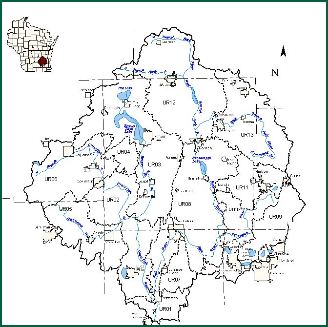
6B Miles of the Rock River mainstream are in the Lower Rock River Basin
Rock Lake is Located in Watershed UR0C
Property Taxes (for storm water) for a typical large institution in Watertown are $D
The second numeral in the Surface Water Line ID of this creek is E
The Department of Commerce began monitoring construction site stormwater discharge in 199F
Wisconsin adapted the nation's strongest stormwater regulations in 200G
There are H municipalities in the Upper Rock River Basin with populations over 5000
Watertown is shared by I watersheds, according to the map
The final cache is located in watershed UR0J
Additional Hints
(No hints available.)