Erie AZ Traditional Cache
-
Difficulty:
-

-
Terrain:
-

Size:  (small)
Please note Use of geocaching.com services is subject to the terms and conditions
in our disclaimer.
A Benchmark Cache
 While up on Badger Mountain we were searching for the Erie
benchmark. The coordinates for the benchmark and its companion
Badger
benchmark place them inside the fence around the tower and the
ground is covered by river rock.
Are they there under the river rock or have they been
destroyed?
Erie
Reference Mark A (RMA) can be found easily nearby and also
provides the evidence that the two benchmarks are gone. How? Well
the description says that RMA is 10 feet below the benchmark. The
location the GPS points to then should be higher than RMA but is
instead about 5 feet lower, probably from them leveling the large
area for tower.
So the benchmark is gone but RMA can be found. How about the
Azimuth mark? These are usually harder to find because the
description is never as detailed as the description on how to find
the benchmark. For this mark the 1956 report just says that:
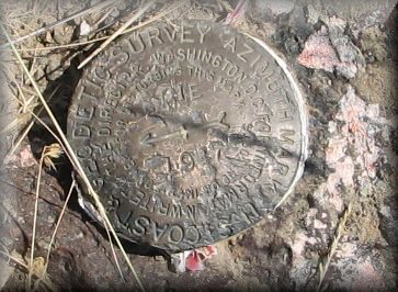
THE AZIMUTH MARK IS A STANDARD DISK STAMPED ERIE 1947
SET IN A DRILL HOLE IN A BURIED BOULDER WHICH PROJECTS ABOUT 1
INCH. IT IS LOCATED ABOUT 0.1 MILE EAST OF THE STATION ON A POINT
OF THE RIDGE WHICH IS ABOUT 100 FEET LOWER THAN THE
STATION.
and the 1971 report says that:
IT IS 21 FEET NORTH OF THE APPROXIMATE CENTER OF THE
TRACK ROAD.
The survey control box says that the azimuth mark is at an 099° 10'
18.1 angle from the benchmark. So now what to do?
I leave the GPS set to the Erie benchmark and start walking at at a
bearing of 261° (360°-99°). I get a tenth of a mile away from Erie
but do not see any disk. Of course looking for a round disk in the
cheat grass may not be easy. Then I look ahead and about another
tenth of a mile ahead I see an orange post that usually mark
benchmarks. Getting to it I did not see any benchmark.
I read the description again and see that it says the disk should
be 21 feet north of the dirt road. I am at least 50 feet from the
road, so I start walking to the road and, sure enough, there is the
disk! This disk cannot be logged on GC.com like RMA can, but it is
still a challenge that was fun to find.
Now that I have done all that work, a cache would be a good thing
to plant nearby. Find the cache and for fun find the azimuth mark.
Remember - "you are the search
engine"
Join the local discussion: South
Eastern Washington Geocachers Forum ![Profile for YeOleImposter Profile for YeOleImposter]()
Additional Hints
(No hints available.)