English version:
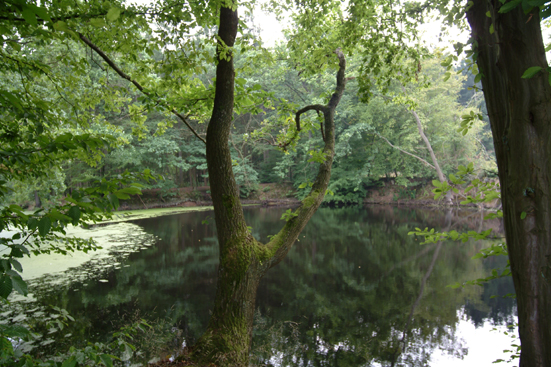
This Earthcache takes you to the sinkholes called "Rüensiek" at the “Hildesheimer Wald” near Söhre. At this Cache-Site you will find near to the edge of the forest a waterfilled sinkhole with the typical cliffy edge.
A sinkhole, also known as a sink, shake hole, swallow hole, swallet, doline or cenote, is a natural depression or hole in the surface topography caused by the removal of soil or bedrock, often both, by water. Sinkholes may vary in size from less than a meter to several hundred meters both in diameter and depth, and vary in form from soil-lined bowls to bedrock-edged chasms. They may be formed gradually or suddenly, and are found worldwide.
To log this earthcache, please take if it is possible a photo (it is not required) of you with the sinkhole behind you and send me an e-mail with the answers of following questions:
- What ist the diameter of the sinkhole? (To get the diameter of the sinkhole please measure the distance in South - North direction)
- What is the name of the biggest doline/sinkhole in lower Saxony?
If the answers are correct you will get no reply, if not i'll contact you.
Deutsche Version:
Dieser Earthcache führt euch zu den Erdfällen Rüensiek am Hildesheimer Wald nahe Söhre. An diesem Cache findet ihr nahe am Waldrand einen mit Wasser gefüllte Korrosionserdfall mit der typischen steilen Uferböschung .
Als Erdfall oder Doline (von slawisch dolina: Tal) bezeichnet man eine schlot-, trichter- oder schüsselförmige Senke von meist rundem oder elliptischen Grundriss in Karstgebieten
In Norddeutschland entstanden Erdfalltrichter über Salzstöcken, die zuvor durch Grundwasserablaugung ausgehöhlt worden und eingestürzt waren. Oft entwickelten sich darin Seen oder Moore.
Um diesen Earthcache loggen zu können, macht bitte wenn möglich ein Foto (keine Bedingung) von euch mit dem Erdfall im Hintergrund und beantwortet folgende Fragen per E-Mail:
- Wie gross ist der Durchmesser des Erdfalls? (Für die Ermittelung des Durchmessers bitte in Süd - Nord Richtung messen)
- Wie heißt die/der größte Einzeldoline/Erdfall in Niedersachsen?
Wenn die Antworten richtig sind bekommt ihr keine Antwort von mir und dürft loggen anderfalls melde ich mich per mail.