The Geological Formation of the
Upper Falls
Typically, a river or a stream in this case, flows over a large
step in the rocks which may have been formed by a fault line. Over
a period of years, the edges of this shelf will gradually break
away and the waterfall will steadily retreat upstream, creating a
gorge of recession. Often, the rock stratum just below the more
resistant shelf will be of a softer type, meaning undercutting, due
to splashback, will occur here to form a shallow cave-like
formation known as a rock shelter or plunge pool under and behind
the waterfall. Eventually, the outcropping, more resistant cap rock
will collapse under pressure to add blocks of rock to the base of
the waterfall. These blocks of rock are then broken down into
smaller boulders by attrition as they collide with each other, and
they also erode the base of the waterfall by abrasion, creating a
deep plunge pool.
The Little Stony Creek, as with other waterfalls, becomes wider
and more shallow just above waterfalls due to flowing over the rock
shelf, and there is usually a deep pool just below the waterfall
because of the kinetic energy of the water hitting the bottom. At
the Upper Stony, you will see the results of this geological
change. Remember, it took thousands of years for all of this to
happen!
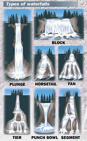
This is a classification of waterfalls
including the most common types :
Block: Water descends from a relatively wide stream or
river. Water descends a series of rock steps.
Cataract: A large waterfall.
Fan: Water spreads horizontally as it descends while
remaining in contact with bedrock.
Horsetail: Descending water maintains some contact with
bedrock.
Plunge: Water descends vertically, losing contact with the
bedrock surface.
Punchbowl: Water descends in a constricted form, then
spreads out in a wider pool.
Segmented: Distinctly separate flows of water form as it
descends.
Tiered: Water drops in a series of distinct steps or
falls.
Multi-Step: A series of waterfalls one after another of
roughly the same size each with its own sunken plunge pool.
 Some Of The Types
The Little Stony Creek flows for about 2.8 miles through a gorge
that is 400 feet deep and 1700 feet wide. Of the two magnificent
falls, this is the Upper and is narrow but fairly high. Be sure to
walk on down the trail a bit and see the Middle falls.
In order to receive credit for this Earthcache you must do
ALL the following:
1. Email us with answers to the following questions:
A. Estimate to within 10+/- feet the height and width of the
falls,
B. From the above classification, what type is this
waterfall?
2. Take and upload a photo your GPSr pointing to the defining
characteristic (see definitions) of the the waterfall. While it
would be nice, you do not have to have to show your face(s) in the
photo.
Thanks and we sincerely hope you enjoy.
Please note: There is no need to leave the trails
and above all, do not disturb the surroundings. Leave the area
cleaner (CITO) than you found it.
This Earthcache was approved by the
Geological Society of America
| We have earned GSA's highest level: |
 |