Different parts of the only island in the province of North Holland, Texel, are Geological Monuments. One of them is the Slufter. It is a tidal inlet from which the area has an open connection with the sea and it contains a creek system with associated salt march vegetation.
The age of the wests coast of Texel varies from late till recent Holoceen. The history of the Slufter goes back to the seventeenth century. At that time Texel was a lot smaller than today. To the north a small dune island was situated, called Eijerland. Between these two islands an area of wetlands with large sandbanks and creeks was located. Around 1630 the islanders built a sand dyke across the highest part of the sandbanks by trapping sand with reed mats. More and more sediment built up so that in 1835 it was possible to reclaim the Eijerland polder, the largest Polder of Texel. In 1856 the sea broke through the dyke and created holes in three places. Two of the gaps were filled, but attempts to repair the third failed. Since then the area situated between the Muy and the Eierland Dunes has an open connection with the North Sea, the so-called Slufter. Nowadays the Slufter covers an area of 455 ha being a long, narrow plain intersected by a creek system. During flood tides the whole area is under water.
To log this cache, you must do two things:
1: Take a picture of yourself and your GPS with the Slufter on the background and upload it with your log
2: Mail me the difference in height from the viewing point and the Slufter, don't write it in your log. You do not have to wait for approval, if the answer differs a lot, we will contact you.
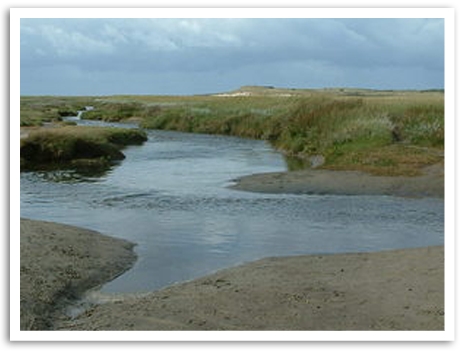
Verschillende delen van het enige eiland van de provincie Noord Holland, Texel, zijn uitgeroepen tot Aardkundig Monument waaronder de Slufter, waar een actief geulsysteem is en het enige natuurlijke duindoorbraaksysteem van Nederland.
De ouderdom van de westelijke kuststrook van Texel varieert van laat tot recent Holoceen. De geschiedenis van de Slufter gaat terug tot de zeventiende eeuw. Texel was toen een stuk kleiner. Aan het noorden lag een klein waddeneiland, Eijerland. Tussen deze eilanden bevond zich een gebied van zandbanken en kreken. Door de aanleg van stuifdijken tussen deze eilanden ontstond een nieuw gebied, de Eijerland polder, de grootste polder van Texel. In 1856 brak deze duinenrij echter op drie plaatsen door, waardoor een zoetwatermeer (de Muy) en een zich actief verplaatsend getijdensysteem met kwelders, kreken en wadplaten ontstonden. In 1878 werden twee doorbraken hersteld. Pogingen om het derde gat te dichten mislukten echter. Het gebied tussen de Muy en Eijerland dat ontstond staat in een open verbinding met de Noordzee, de zogenaamde Slufter. Deze beslaat tegenwoordig een gebied van ca. 455 ha. met een actief geulsysteem Bij vloed loopt de Slufter onder water.
Om deze cache te loggen moet je twee dingen doen:
1: Neem een foto van jezelf en je GPS met de Slufter op de achtergrond en plaats deze bij je log
2: Mail me het hoogteverschil tussen het uitkijkpunt en de Slufter, plaats dit niet in je log. Je hoeft niet te wachten op goedkeuring, mocht het antwoord veel afwijken dan nemen we contact op.