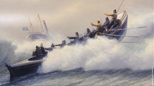
The RNLI braving difficult conditions to rescue in the
1800s
For out in the sand...... along this part of the coast...... are
buried more than three hundred shipwrecks. Some are quite
visible at low tide and then there are organised walks to them.
And it's here that the worst disaster in lifeboat history
occured. Involving the four hundred ton Mexico on December 9th 1886
in a very severe west north westerly, that night twenty-seven of
the lifeboatmen lost their lives, other lifeboatmen survived to
rescue the Mexico crew of twelve.
Background to this cache
This cache was originaly Angry Horse, but after it was muggled and
I moved it some distance I thought it was best to start afresh, so
here is Angry Horses.
On the way to the cache:
You might think that someone has had a great time dumping rubbish
here but this is in fact flotsam and jetsam - items that have been
washed up with the tide. The children might like to write down all
the different things and take photos for school. See how many tree
trunks have been washed up! See if there are any items from foreign
lands! Somewhere there may be a message in a bottle from a
shipwrecked pirate who's on a distant desert island!
There are two ways to approach the cache site, and it's the
route seaward from the car park that attracts the flotsam and
jetsam. However, this route will most probably be initially quite
muddy and wet.
The second route is over a stile slightly north east along the
main road past the area that was the sand winning plant.
If there is a particularly high tide the cache can still be
approached but maybe not by the normal paths - then there may be
some short, steep climbing required in places.
There is a high tide table giving time and height posted
in the Wildfowl Hut located about two minutes walk north up the
main road.
The cache:
In a small clip-it box.
After replacing the cache please, please, please, fluff up the
vegetation to hide the cache, and also around it so that the area
looks undisturbed. I do this as a matter of course as part of
re-hiding a cache to prevent muggles from having their way.
Thanks!
PLEASE AS A PERSONEL REQUEST NO BORING ONE LINE LOGS.
When finished:
Take a few moments to ponder the extensive vista - the
wildfowl, the vast Irish Sea, and the Lake
District Hills. Bring some binoculars!

...and imagine what it might have been like here
on a stormy dark night, having been shipwrecked
and trying to cling to flotsam or jetsam
in a cold, dark sea
Parking: see Additional Waypoints for information
and map.
Websites:
Organised Southport wreck walks
The Royal National Lifeboat
Institution
Liverpool Tide Times and Heights