
 Parking is along the wide dirt shoulder of the highway.
The Picacho basin is in what is called the Basin and Range
Province. This area is characterized by mountain ranges separated
by deep valleys. Typically these valleys have been largely filled
with sediment washed down from the surrounding mountains. The
Pacacho basin is filled with over 2,310 feet of sediment. This
sediment is typically fine to coarse grained unconsolidated sand
with some layers of clay and silt.
Before large-scale pumping began ground water was found about 59
feet below ground. In the mid-1930s, agriculture based on
irrigation from ground water became widespread in the basin. Ground
water extraction far exceeded the recharge and water level began
declining. Ground water was being mined since it was being taken
out faster than it was put back. By 1962 ground water levels had
fallen about 132 feet.
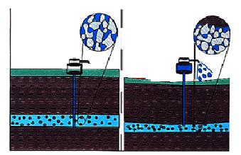 Ground water actually helps keep individual grains in
the ground apart. Once the water is removed, the grains are
compacted closer together by the weight of the grains above. This
decreases the elevation of the area. This is also a permanent, so
even if the ground water level comes up again, the ground surface
does not move. The compaction also reduces the volume of water that
can be stored in the aquifer.
Ground water actually helps keep individual grains in
the ground apart. Once the water is removed, the grains are
compacted closer together by the weight of the grains above. This
decreases the elevation of the area. This is also a permanent, so
even if the ground water level comes up again, the ground surface
does not move. The compaction also reduces the volume of water that
can be stored in the aquifer.
This well was constructed to be level with ground when it was
installed. It was drilled deep into the sediments, far below the
water table. The upper layers of sediment have compacted lowering
the elevation of the surrounding land. However, the well cannot
move down with the ground surface because its foundation (the
bottom of the well) is below the sediment that has compacted. The
result is that the top of the well is now sticking up in the
air.
Logging requirements:
Send me a note with :
- The text "GC17N94 The Sinking Picacho Basin" on the first
line
- The number of people in your group.
- On the side closest to the benchmark, measure the distance from
the ground surface to the top of the concrete slab. Estimate if you
can’t get across the drainage ditch.
The above information was compiled from the
following sources:
- Field Guide to Earth Fissures and Other Land
Subsidence Features in Pacacho Basin, Arizona Geological Society,
Arizona Hydrological Society Fall 1999 Field Trip November 13,
1999, Arizona Geological Survey Open-File Report 99-26
- EARTH FISSURES: ARIZONA’S CRACK PROBLEM
An interdisciplinary science module incorporating geological,
chemical, biological, and engineering concepts in the evaluation of
earth fissures. Departments of Physical and Life Sciences Mesa
Community College, December 21, 2001