
 Parking is along an unused portion of a public road on the downhill side (N33 35.856 W111 50.555). Walk back over the aqueduct to the trailhead at N33 35.930 W111 50.483. The fissure can be seen from behind the dilapidated barbwire fence.
Phoenix is in what is called the Basin and Range Province. This area is characterized by mountain ranges separated by deep valleys. Typically these valleys have been largely filled with sediment washed down from the surrounding mountains. These basins are sometimes filled with over thousands feet of sediment. This sediment is typically fine to coarse-grained unconsolidated sand with some layers of clay and silt. Over the millions of years, ground water has also accumulated in the sediments of these basins.
In the mid-1930s, agriculture based on irrigation from ground water became widespread in southern Arizona. In the current desert climate, little water percolates down to replenish the water that was pumped out. So ground water extraction far exceeded the recharge and water levels began declining. Ground water was being mined since it was being taken out faster than it was put back. In places ground water levels have fallen over 100 feet.
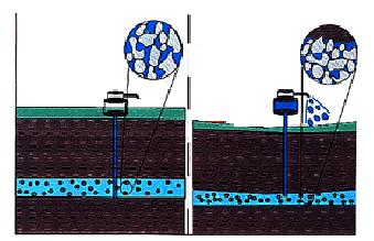 Ground water actually helps keep individual grains of the unconsolidated sediment apart. Once the water is removed, the grains are compacted closer together by the weight of the sediment above. A comparison is a sponge that has a weight on it. As the water in the sponge is removed, the thickness of the sponge decreases. The result is that the land sinks.
 In the middle of the basin, where the sediment is thickest, the sediment compacts more than at the edge of the basin. Using the example above, there is a thicker sponge in the middle of the basin than at the edge. The effect is the same if there is a bedrock ridge or fault buried in the middle of the basin.
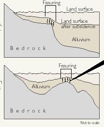
 These cracks actually begin deep in the ground near the water table and work their way upward. Then after a heavy rainfall event, the roof of the crack collapses in to the crack creating a sudden appearance of a deep fissure or series of fissures. Typically these fissures are long and roughly straight. Over the years these fissures are gradually filled in unless land subsidence continues.
Logging requirements:
Send me an email with:
- The text "GC17RPD Earth Fissure of Scottsdale" on the first line
- The number of people in your group.
- Based on the direction the fissure is going, do you expect it to be a threat to any nearby features?
- How deep do you think these fissures are?
- Based on the surrounding landscape, do you think they were caused by a buried ridge or fault or because they are at the edge of the basin?
The above information was compiled from the following sources:
- Arizona Geological Survey, Earth fissures and subsidence complicate development of desert water resources. On-line PDF Document.
- Harris, Raymond C. November 13,1999, Field Guide to Earth Fissures and Other Land Subsidence Features in Pacacho Basin, Arizona Geological Survey Open-File Report 99-26, Arizona Geological Society Fall 1999 Field Trip Arizona Department of Water Resources
- Phoenix AMA Fissure Zone 4 Baseline and Meridian area http://www.azwater.gov/dwr/Content/Hot_Topics/Earth_Fissures_in_Arizona/fissures_phx_z4.pdf