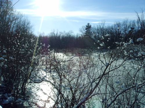
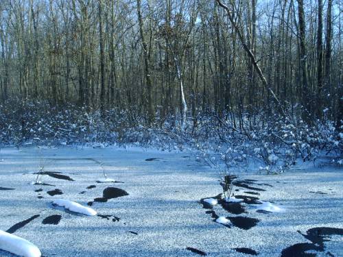
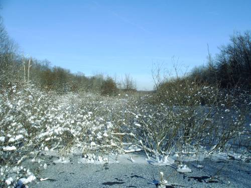
The Great Marsh
Photos by 501 Gang
It is estimated that the U.S. has lost more than half of its wetlands since the late 1700s, and Indiana alone has lost approximately 85 percent of its original wetlands. The Great Marsh is one of the few remaining naturally occurring wetlands in Indiana and was once home to a vast number of native species including sedges, grasses, rushes and shallow marsh forbs.
In the late 19th century and early 20th century, there was an intensive effort to drain the Great Marsh, part of the Indiana Dunes National Lakeshore, by creating ditches to adapt the area for commercial ventures such as agriculture, residential development and road building. The Great Marsh along the Indiana shoreline was drained in Porter County to create the Burns Ditch, now known as Burns Waterway. Segments of the Great Marsh were salvaged in LaPorte County. However the ditching, farming, residential development and other disturbances in the area resulted in damaged plant communities, invasive plant species and polluted waters.
The Indiana Dunes National Lakeshore is in the process of restoring the Great Marsh by plugging ditches, restoring the area’s hydrology, removing invasive plants and planting native species. Because wetlands naturally filter contaminated water, restoring the Great Marsh will help to improve the area’s water quality. More funds are needed to complete the restoration efforts and recreate this diverse and beautiful ecosystem.
Hydrologic History of the Lake Michigan Basin in Indiana
The surface waters of the Lake Michigan coastal area include Lake Michigan; the Little Calumet River, the Grand Calumet River, the Galena River, and Trail Creek; several smaller tributaries and man-made ditches; many natural and man-made lakes; ponds and man-made excavations; and scattered remnants of marshes, swamps, and other wetlands. The present hydrology of the Lake Michigan coastal area in Indiana is significantly changed from what existed before development. The industrialization and urbanization which began in northwest Indiana during the late nineteenth century extensively altered the natural landscape and the natural drainage patterns.
Between the Calumet Beach Ridge (a narrow area just south of the west arm of the Little Calumet River) and the Lake Michigan sand hills formed over years by fluctuating lake levels, a vast wetland existed. From Michigan City west through the Indiana Dunes National Lakeshore lay the Great Marsh, which averaged half a mile in width. The Great Marsh was centered on Dunes Creek, which flowed through a channel in Lake Michigan between the dunes. The enormous wetland complex evolved as back waters of Dunes Creek and Calumet Rivers, and as lagoons that were left standing after Lake Michigan finally retreated to its present lake level.
Portions of the Great Marsh still exist at its eastern- most points. A remaining example of the pockets of wetlands among the sand hills may be found behind the foredunes on present-day West Beach near Ogden Dunes. There were also parallel beach ridges with intervening swales which contained classic interdunal wetlands such as the ones found in Miller Woods at Gary.
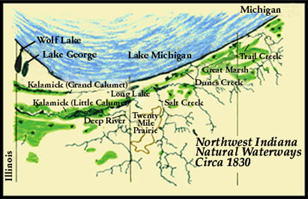
In 1850, Congress gave the "swamp lands" of the country to the individual states in which they were located. The swamp lands were to be sold and the money used to drain and "reclaim" the lands. Swamp land in the Calumet region sold for an average of $1.25 per acre.
A second waterway formed in about 1800 when a new channel to Lake Michigan in Illinois was opened by the Native Americans. Canoes were pushed and pulled through the marshes between Wolf Lake and Lake Calumet until a permanent channel was opened to Lake Michigan about twelve miles south of the Chicago River. The southern river, flowing west across the Calumet region and discharging into the Lake from Illinois became the Little Calumet River. The northern river, flowing east and discharging into the Lake in Indiana became the Grand Calumet River.
The mouth of the river in Illinois was cleared in 1870 for the development of Calumet Harbor. By 1872 the mouth of the river in Indiana was so clogged with aquatic vegetation and sand that it no longer could empty into the Lake. A map made by the US Topographic Bureau in 1845 showed that the Grand Calumet River no longer flowed into Lake Michigan in Indiana.
The Lake Michigan watershed was further modified when Hart Ditch was constructed from the town of Dyer to a site near Munster in 1850 to improve local drainage. The watershed of Hart Ditch was enlarged when Cady Marsh and Spring Street Ditches were created to drain areas where Highland, Griffith and Schererville are now located.
In 1908, Randall Burns of Chicago launched an effort to "reclaim" the land. The high sands of the Tolleston Beach and the dunes separating the marsh and Lake Michigan were cut. The flow of the Little Calumet and the Deep River, which joins the Little Calumet, were diverted into the lake just east of Ogden Dunes. The Little Calumet was also dredged to the mouth of Salt Creek. These projects reclaimed more than 20,000 acres in Porter County and in Gary.
Dredging is still conducted along the Calumet River system to maintain navigation channels at authorized depths to accommodate deep-draft vessels. Contaminants in dredged spoil; however, pose serious environmental concerns. The flood plain of the Little Calumet River and its tributaries is one of the most flood-prone areas in the state.
For more:
Hydrologic History
Wetlands and Drainage
The Great Great Marsh Earth Cache is located at the Indiana Dunes State Park on trail 8. There is the standard gate fee to enter the park ($4 weekday, $5 weekend, $10 out of state).
You can also buy an Annual entrance permit (Indiana State resident) or Non-resident annual entrance permit (Out of state resident) which will get you into ALL the Indiana State Parks for the year!
I Recommend parking at the Nature Center:
Parking coordinates - N 41° 39.560 W 087° 02.960
Alternate Parking - N 41° 39.442 W 087° 02.883
Enjoy your walk to the Great Marsh and the beautiful views you will see.
To be able to claim a smiley for this Earth cache, you must:
1. Take a picture of yourself/ group at the information sign in the middle of the boardwalk crossing the Great Marsh.
2. Email me the width of the Great Marsh in the area that you are at. You can do this by measuring the boardwalk that you are on. (Failure to do so will result in a removal of your log)
Please email me your answers, I don't like the message center so I won't be using it, thanks
** Please note: The DNR has asked that cachers stay on the trails, do not enter into the Great Marsh itself because of the rare and sensitive species that occur there. Logs mentioning or photo's showing cachers off trail will be deleted. **
