Plein gaz à Beynes Multi-cache
-
Difficulty:
-

-
Terrain:
-

Size:  (small)
Please note Use of geocaching.com services is subject to the terms and conditions
in our disclaimer.
[FRANÇAIS]
Dans la forêt de Beynes (78)
La forêt de Beynes est connue pour les caractéristiques géologiques particulières de son sous-sol, ce qui lui permet d'héberger l'un des 12 reservoirs de gaz naturel existant en France.
Il s'agit en fait de deux réservoirs distincts superposés : 'Beynes Supérieur', mis en service en 1956, d'une capacité de 500 millions de mètres cubes, situé à 430 m. de profondeur, et 'Beynes Profond', mis en service en 1975, d'une capacité de 800 millions de mètres cubes, situé à 740 m. de profondeur.
La présence de ces réservoirs font de la forêt de Beynes un lieu bien entretenu, et agréable pour les promeneurs.
Garez-vous sur le petit parking proche de la maison forestière de Saint-Hubert, aux coordonnées indiquées ci-dessus, et rejoignez à pied le WP1, situé à 350 mètres, au cap 281°
Une fois arrivé à WP1, déterminez les coordonnées de WP2 en vous aidant des tableaux ci-dessous :
Les coordonnées de WP2 sont : N 48° 51.ABCD' E 1° 50.EFG'
A = Déterminé par la constitution géologique du sous-sol, qui a permis à Gaz de France d'installer ici un stockage de gaz naturel
| Argile/calcaire |
0 |
| Argile/sable |
1 |
| Sable/limons |
2 |
| Grés/calcaire |
3 |
| Travertin/Limons |
4 |
BCD = Superficie de la forêt de Beynes (en ha), après conversion
EFG = Altitude moyenne du plateau où se trouve la forêt (en mètres), après conversion
Abaque de conversion
| 1 |
2 |
3 |
4 |
5 |
6 |
7 |
8 |
9 |
0 |
| 3 |
0 |
4 |
9 |
1 |
8 |
7 |
5 |
2 |
6 |
Exemple :
Si le sous-sol est constitué d'argile/sable, la surface de la forêt 497 ha et l'altitude moyenne 208 mètres, les coordonnées de WP2 seront :
N 48° 51.1927' E 1° 50.065'
Une fois arrivé à WP2, vous y trouverez les coordonnées de WP3
Une fois arrivé à WP3, vous y trouverez les coordonnées de WP4
Et ainsi de suite, jusqu'à la cache finale, constituée d'une boite genre Tupperware taille moyenne (1 litre).
L'ensemble du circuit fait près de 3 km à vol d'oiseau : Prévoyez donc de consacrer plusieurs heures à cette recherche.
Sur le parcours, vous rencontrerez plusieurs tables de pic-nic : Vous pouvez donc apporter votre déjeuner.
Certains des Way-Points sont situés au milieu des arbres : Il est donc recommandé de s'équiper de bonnes chaussures, d'autant plus que par temps humide, certains sentiers sont boueux.
------------------------------------------
[ENGLISH]
In the forest, near Beynes (78)
The Beynes's forest is well known for the geological characteristics of its undergrounds, which make possible the existance of one of the 12 reservoirs for natural gas existing in France.
In fact, there are two reservoirs, one above the other : 'Beynes Supérieur', open in 1956, can contain 500 millions square meters, located at a depth of 430 m, and 'Beynes Profond', open in 1975, can contain 800 millions square meters, located at a depth of 740 m.
Those existing gas reservoirs make the Beynes's forest a very clean one, and a very nice place for leisure walks.
Park your car at the small parking-place, near the 'Maison forestière de Saint-Hubert', at coordinates indicated above, and walk toward WP1, located at 350 meters, at bearing 281°
When you are at WP1, find the coordinates for WP2, using the two tables below :
WP2 coordinates are : N 48° 51.ABCD' E 1° 50.EFG'
A = Given by the geological type of the underground, which allow 'Gaz de France' to install a gas-reservoir here.
| Argile/calcaire |
0 |
| Argile/sable |
1 |
| Sable/limons |
2 |
| Grés/calcaire |
3 |
| Travertin/Limons |
4 |
BCD = Size of the Beynes's forest (in ha), after conversion
EFG = Mean altitude of the forest plateau (in meters), after conversion
Conversion table
| 1 |
2 |
3 |
4 |
5 |
6 |
7 |
8 |
9 |
0 |
| 3 |
0 |
4 |
9 |
1 |
8 |
7 |
5 |
2 |
6 |
Example :
If the underground is made of argile/sable, the size of the forest is 497 ha and the mean altitude 208 meters, the WP2 coordinates will be :
N 48° 51.1927' E 1° 50.065'
At WP2, you will find the coordinates for WP3
At WP3, you will find the coordinates for WP4
And so on, up to the final cache, which is a box like a medium size Tupperware (1 liter).
The whole circuit is about 3 km long, from bird eyes : Allow at least several hours for this seek.
On the way, you will find several pic-nic tables : So, you can bring you own food (or BYOB...).
Some of the Way-Points are located right in the middle of the trees : You have better to have good shoes. Furthermore, by wet weather, some trails are rather muddy.
------------------------------------------
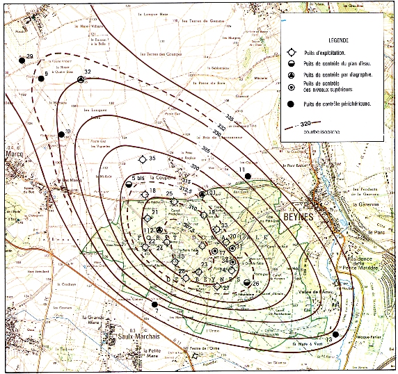
Carte montrant l'extension du réservoir supérieur
Additional Hints
(Decrypt)
[Fr]
JC 1 : Rager har Crgvgr-Gnoyr rg har tenaqr gnoyr.
JC 2 : N y'rzcynprzrag q'har napvraar étyvfr,vapraqvér ra 1709.
JC 3 : Abve fhe ireg.
JC 4 : Qrf pbbeqbaaérf dhv sbag fbhpur.
JC 5 : Iblrm yr oba pbgé qr yn pubfr.
JC 6 : Nh perhk q'ha abvfrgvre.
[English]
JC 1 : Orgjrra n Crgvgr-Gnoyr naq n ynetr gnoyr.
JC 2 : Ng guvf ybpngvba jnf na byq puhepu, qrfgeblrq ol sver va 1709.
JC 3 : Oynpx bire terra.
JC 4 : Pbbeqvangrf ba n fghzc.
JC 5 : Frr gur evtug fvqr bs guvf guvat.
JC 6 : Evtug va gur zvqqyr bs n unmry.