From the guidelines, as from January 2013"People do not need to wait for permission to log your EarthCache. Requiring someone to wait is not supported by the EarthCache guidelines. People should send their logging task answers to you, then log your EarthCache. When you review their logging task answers, if there is a problem, you should contact them to resolve it. If there is no problem, then their log simply stands."

Because the outer layer of the earth's crust is relatively cold, any rocks that suffer quick deformation as a result of internal geodynamic processes tend to fracture/break. These breaks across which the rocks have slipped are called faults. Therefore, the creation and behaviour of faults, in both an individual small fault and within the greater fault zones, is controlled by the relative motion of rocks on either side of the fault surface.
The mechanisms of faults can be very complex and should the reader want, there are plenty of reference data on the www that can be accessed. However, to keep it simple let's assume that in a particular situation the rigidity of the rock prevents the rocks from simply gliding or flowing past each other. Stress builds up in rocks and when it reaches a level that exceeds the strain threshold, the accumulated potential energy is released as strain, which is focused into a plane along which relative motion is accommodated — the fault.
Fault types
There many fault types but mostly are variations of the basic 3 that are based on the sense of slip:
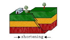
Type 1 - A fault where the main sense of movement (or slip) on the fault plane is vertical is known as a dip-slip fault. More complex dip slip faults can cause the formation of grabens as in the image below.

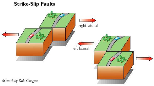
Type 2 - Where the main sense of slip is horizontal the fault is known as a transcurrent or strike-slip fault. Oblique-slip faults have significant components of both strike and dip slip. Depending on which side of the fault moves, you can have dextral (right lateral) or sinistral (left lateral) faults.
Type 3- A fault where the main sense of movement (or slip) on the fault plane is vertical but in the reverse direction of dip, is known as a thrust fault.
The evidence of faulting
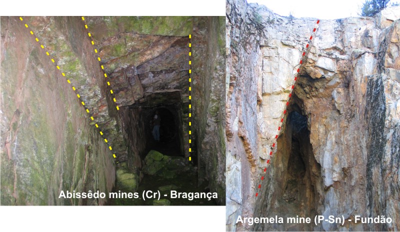
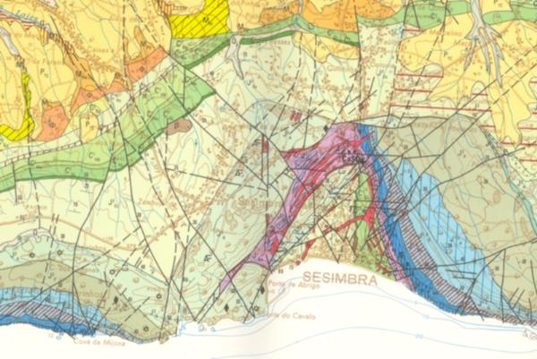
Faulting is in many cases a subtle occurrence because of associated processes of erosion and deposition. In many instances, you can clearly see the fault line (Argemela and Abissêdo images below) while in others you have to infer the fault line due to lateral discontinuities in the lithologies (example from geological map).
In many cases all that you see is simply the fault plane while the sense of displacement is not readily apparent.
The cache:
The coordinates will take you to a pleasant location by the seaside where you can have a leisurely stroll or sit down and have a pleasant cup of coffee. You will also be confronted with a clean fault line. The line is slightly curved as can often occur with faults but I need you to measure the general orientation of the fault. Send the answer by e-mail through my profile to validate your log. Enjoy it!
ps. No photos in the logs that will give away the answer. Thanks.

Uma Falha geológica , ou simplesmente falha é uma superfície num volume de rocha onde se observa deslocamento relativo dos blocos paralelo à fractura.
A extensão da falha varia entre centenas de quilômetros a poucos centímetros. O plano de falha é a superfície da fratura onde se observa deslocamento relativo entre blocos, e suas dimensões também podem variar de forma ampla.
Existem essencialmente 3 tipos de falhas:
Tipo 1 - Falhas normais ou de gravidade: são aquelas produzidas pela compressão vertical (e portanto por forças de extensão entre os blocos) causada devido à expansão da crosta terrestre. - vêr imagens anteriores.
Tipo 2 - Falhas laterais, transcorrentes, de desligamento ou de deslocamento: são aquelas causadas igualmente por forças horizontais, sendo porém o plano de falha exclusivamente vertical. - vêr imagens anteriores.
Tipo 3 - Falhas contrárias (ou inversas) de empurrão ou de cavalgamento ou de compressão: são aquelas que resultam das forças compressoras horizontais causadas pela contração da crosta terrestre, ou por encolhimento. - vêr imagens anteriores.
A cache:
As coordenadas desta cache indicam um local agradável à beira-mar onde se pode passear calmamente ou então sentar para apreciar um cafézinho e uma paisagem serena. Nas coordenadas terão um plano de falha. Para poder logar a cache quero que meçam a orientação da falha, enviem-me a resposta por e-mail para validar o found.
ps. não colocar fotos do local onde a falha se encontra para não divulgar a resposta.

 The most exciting way to learn about the Earth and its processes is to get into the outdoors and experience it first-hand. Visiting an Earthcache is a great outdoor activity the whole family can enjoy. An Earthcache is a special place that people can visit to learn about a unique geoscience feature or aspect of our Earth. Earthcaches include a set of educational notes and the details about where to find the location (latitude and longitude). Visitors to Earthcaches can see how our planet has been shaped by geological processes, how we manage the resources and how scientists gather evidence to learn about the Earth. To find out more click HERE.
______________________________________________________________________________