Sand, Sand Everywhere EarthCache
-
Difficulty:
-

-
Terrain:
-

Size:  (other)
Please note Use of geocaching.com services is subject to the terms and conditions
in our disclaimer.
An easy and fun Earthcache located in a great kids park.
If you live in the Tri-County area, you may be used to seeing sand everywhere. But, did you ever stop to think of where that sand may have come from? When we walk around in the mountains and we see rock everywhere, it’s pretty obvious…rocks…mountains – they just seem to go together. But..sand everywhere when we don’t see any oceans or even large lakes next to us?? How did that happen?
It’s hard to believe walking around parts of Saratoga, Albany and Schenectady Counties that only several thousand years ago this area and much of the surrounding area was part of a great lake known as Glacial Lake Albany. What’s even better is how the lake was formed.
As you probably know, New York and much of New England were once covered by glaciers. The most recent of these glacial episodes occurred approximately 12,000 – 15,000 years ago and is responsible for much of the surficial geology we see today.
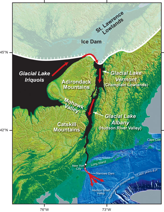
Glaciers are masses of ice that move over land by gravity. Glaciers that are over one-half of one mile thick, and cover large areas of a continent are called continental glaciers or ice sheets. Glacial Lake Albany was formed approximately 15,000 years ago when water melting from the a portion of the Wisconsonian Ice Sheet known as the Hudson Valley Lobe (a large finger or extension of a continental glacier) was dammed by glacial debris located within the area known as “the Narrows” that was just north of New York City.
At its largest size, Glacial Lake Albany occupied the Hudson River Valley from the Newburgh area to Glens Falls. In the upstate area, the shore of the lake was found at the 450 foot elevation contour. As the glaciers retreated, sediments were carried by melt-waters and deposited into Glacial Lake Albany.
As the climate of the Earth warmed and the glaciers retreated further large ice dams melted that enabled the release of water from nearby glacial Lake Iroquois. As Lake Iroquois drained into the glacial lakes within the Champlain and Hudson Valley areas, the dam at the narrows collapsed and the lakes began to drain at an overwhelming rate into the Atlantic Ocean. Many scientists believe this catastrophic release of fresh water into the Atlantic is responsible for an abrupt climatic change that brought about another cooling period for the Earth that may have lasted hundreds of years.
This photo below from the Woods Hole Oceanographic Institute illustrates it very well.
 As the lakes continued to drain, sands were deposited in large quantities forming delta environments. Eventually, the glacial lake was drained and the delta sands were then exposed to an air (Aeolian) environment. Over time, the prevailing winds shaped these exposed sands into dunes. These dunes can be found throughout the Capital District area. A well known example of these dunes is the Albany Pine Bush area. During the construction of the SUNY Albany campus, the vegetation stabalizing the dunes was removed and the dunes began to move again - causing alot of headaches for the construction crews.
Believe it or not, some of these dunes exist right here at Collins Park. Your job to earn credit for this Earthcache is to find them. Remember, the dunes were formed thousands of years ago – so, they no longer look like dunes you are used to seeing along the shore. The dunes are now stabile with vegetation…..no, not beach grasses.
This is an easy Earthcache, the idea really being to give you an understanding of how drastically our area has changed over time and to give you a visual of how different this area looked only 12,000 years ago. If you are at the park during the summer, walk through the trails and the sands that make up the “dunes” will be even more apparent.
So, to earn your smiley:
Part 1: Walk around and locate what you think is a dune. Start your search on the hills BEYOND the playground equipment. Now, using your GPS, mark the elevation difference between the top and the bottom of the dune and see how high it is.
Part 2: Take a picture of someone in your group on top of the dune. If you are alone, stand at the bottom and take a shot looking up the dune.
Part 3: Upload your photo and EMAIL your answer – DO NOT POST YOUR ANSWER, EVEN IF ENCRYPTED OR WE WILL NEED TO DELETE YOUR LOG!
As always, our EC’s are meant to help you understand a little more about the world around us and how portions of it may have been formed. We aren’t looking to delete smiley’s for wrong answers. We are more interested in seeing that you had fun and may have even learned something new.
Although we read through everyone's answers on all of our EC's we are not able to respond to each one individually. We hope you enjoy this Earthcache and maybe even learn something new about the world around us.
Additional Hints
(No hints available.)