Cossatot is an Native American word that means Skullcrusher and is
the name of the river you'll find at the listed coordinates. "The
Falls" on the Cossatot River are actually one of many places along
the river where the gradient becomes steep enough to create
dramatic rapids, in this case several back to back pool-drop rapids
collectively known as the Cossatot Falls.
When rivers or streams become pinched by the landscape or other
obstructions it creates turbulence in the water known as rapids or
hydraulics. There are many types of hydraulics depending on what
type of obstruction has caused them and what the water does to get
around the obstruction.
A Pillow is formed when the flow of water runs into a large
obstruction that causes it to pile up or boil on its upstream edge.
An object flowing towards the obstruction will be slowed or stopped
by the pillow before sliding to one side and continuing around the
obstruction.
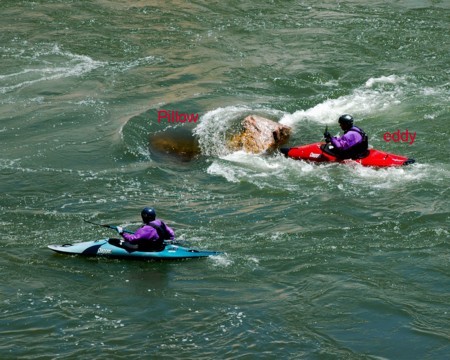
Once past an obstruction the water often forms an Eddy "behind"
the obstruction where the water slows significantly or even flows
upstream. Eddies are often a good place to rest and recover
although especially powerful eddies can actually be hazardous.
A Hole is created when fast moving water flows over the top of
an obstruction into slower moving water downstream. The faster
moving water punches through the surface of the slow moving water
and races along the bottom of the streambed rapidly enough to cause
the surface water to flow back upstream, much like an eddy turned
on its side. At the point of the two meet the surface water dips
down and becomes frothy from aeration. Depending on the size of the
dip and degree of aeration in the hole it can either be a fun place
to play or dangerous.

Some holes form because the fast moving water has fallen from a
higher elevation into water at a lower elevation. This sudden
change of elevation in the surface of the river is called a Drop. A
drop can be anything from a few inches to many feet in height.
A Wave is similar to a hole in that it is formed by fast moving
water flowing over a submerged obstruction, but instead of flowing
into slower moving water continues downstream with its pace
unabated. The resulting mound of water with an upstream facing
slope is the wave and if large enough can be “surfed” the same way
an ocean wave is surfed by sliding “downhill” at the same speed the
water is moving the other way.

All rapids can be classed on the international grading system
which rates the rapid on a scale of I-VI with regard difficulty and
danger. A class I rapid, being the easiest, is little more than
turbulent water that you could float through unaided and where
there is little risk. A class VI rapid is the hardest and generally
considered un-runnable. Sometimes professional whitewater atheletes
with state of the art equipment willing to risk their life will run
such rapids to prove it can be done. After several people have
successfully run a Class VI rapid it will sometimes be downgraded
to Class V+
The drops here at the Cossatot Falls range from Class II to
Class IV but can vary in difficulty depending on recent rainfall.
For the most spectacular view of the falls time your visit after a
heavy thunderstorm or a few consecutive days of moderate rain,
especially during the "leaf-off" season.
The listed coordinates will take you to a parking area near the
top of the falls where a short set of steps will lead you to a calm
area above the falls used by people launching kayaks to run the
falls or by people coming from upstream to get off the river and
portage around the falls. Go to the bottom of the steps and use
your GPS to get a fix, including altitude.
Back in the parking area follow the other path downsteam and
across a small bridge and then continue along the portage path over
the rocks past the falls to the next large calm body of water where
you should find a large sandbar unless the water is really raging.
Get another GPS fix, including altitude, then answer these
questions:
1) How much elevation did you lose and how far did you have to
travel laterally?
2) How many “drops” did you count and which one would you rate as
the most difficult?
3) Note the geology of the land you crossed. What geological
activity do you think caused this terrain? (Hint: you can get this
information at the park visitor center at N 34° 17.643 W 094°
10.695)
4) Get a picture of yourself with your GPSr in front of an
identifiable Cossatot river feature. (a rapid, a rock formation, a
trail sign, etc.)
You and your GPSr must be in the photo and the backdrop must
be something I can identify as the Cossatot. I'm there often so
I'm pretty familiar with the scenery.
If you have privacy concerns turn your back to the camera, hold
a sign in front of your face, blur it out with photoshop, or take a
picture that excludes faces. Enough of "you" must be visable that
cachers who actually know you can say "Yeah, that Bob's (insert
body part here)."
While full details of your visit are enjoyed, please don't post
your answers in your log, except the photo.


Developed by a Silver Earthcache Master
