SALT FORK GAGING STATION
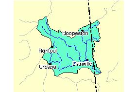
This Earthcache will take you to a USGS Gaging Station on the Salt Fork in Champaign County, Illinois. The Salt Fork is a tributary of the Vermilion River.
During times of potential flooding, field crews from the U.S. Geological Survey (USGS) race to gather vital hydrologic data. They measure the stream flow and water levels to provide the information needed by forecasters, engineers, and emergency managers who rely on data from the USGS network streamflow-gaging stations . Streamflow information saves lives and protects property during floods. Information on the streamflow in the Nation's rivers also helps to ensure adequate water resources for a healthy environment and economy. The U.S. Geological Survey (USGS) operates and maintains a national network of over 7,300 streamgages. The network is funded in a cooperative program of federal, State, and local agencies. Many of these stations are equipped to transmit real-time streamflow data. In times of emergency, real-time streamflow information is a key element in the protection of lives and property.
USGS 03336900 SALT FORK NEAR ST. JOSEPH, IL
LOCATION
Latitude 40°08'58", Longitude 88°02'03" NAD83
Champaign County, Illinois, Hydrologic Unit 05120109
DESCRIPTION
Drainage area: 134.00 square miles
Datum of gage: 650.16 feet above sea level NGVD29.
Record for this site is maintained by the USGS Illinois Water Science Center

Many factors affect drainage in the area. Soil type is important. For example, sandy soils allow the ground to soak up water faster. This reduces surface runoff, but can affect ground water. Clay soils, on the other hand, are tighter and do not allow as much water infiltration. This can lead to more runoff and soil erosion. In the Salt Fork basin land use is 90% cropland consisting of soil mostly composed of Clay and Silt Loam. This increases runoff to the stream because less rainfall soaks into the ground.
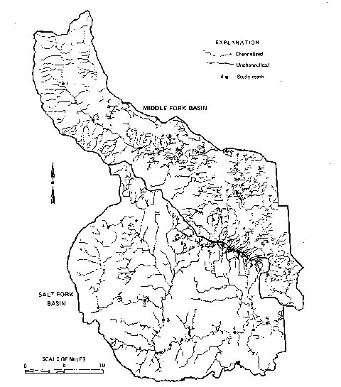
The topography (terrain) is another important feature. How flat or steep the land is impacts how fast water drains. The topography of the area is generally flat and drainage is poor. The upland drainage networks of both the Middle Fork and Salt Fork Basins have been extensively modified. Miles of ditches have been constructed to drain the originally swampy land. Many naturally occurring channels have been widened, deepened, and straightened to improve drainage. Most of the streams up to the main channels of the Middle Fork and Salt Fork Rivers throughout the watershed have been channelized as illustrated below. The main channels of the Middle Fork and Salt Fork are naturally occurring stream channels. In addition to the surface drainage improvements, sub-surface drain tiles have been installed to accelerate drainage in many of the cultivated fields.
Formation of AreaThe retreat of the Wisconsinan glacier was marked by numerous readvances of sufficient duration to construct terminal moraines. The moraines exerted a strong influence on the development of the drainage system by acting as drainage divides. For example, the northern boundary of the basin is defined by the Chatsworth Moraine, and the Gifford Moraine separates the Middle Fork Vermilion from the Salt Fork Vermilion. Other moraines in the basin played an equally important role in the development of the drainage patterns.
REAL-TIME DATA: Real-time data typically are recorded at 15-60 minute intervals, stored onsite, and then transmitted to USGS offices every 1 to 4 hours, depending on the data relay technique used. Recording and transmission times may be more frequent during critical events. Data from real-time sites are relayed to USGS offices via satellite, telephone, and/or radio and are available for viewing within minutes of arrival.
GLOSSARY
• gage height--the height of the water surface above the gage datum (zero point). Gage height is often used interchangeably with the more general term, stage, although gage height is more appropriate when used with a gage reading.
• gaging station--a site on a stream, lake, reservoir or other body of water where observations and hydrologic data are obtained.
• discharge--the volume of water that passes a given location within a given period of time. Usually expressed in cubic feet per second.
• watershed -- the region or area drained by a river, stream, etc.; drainage area.
• moraine -- a ridge, mound, or irregular mass of unstratified glacial drift, chiefly boulders, gravel, sand, and clay.
You can go to this webpage to obtain data provided by this Gaging Station
SALT FORK DATA
In order to get credit for this earthcache you must:
1. Post a picture of you and your GPSr with the gaging station in the background. Also post a picture of the creek at the time of your visit.
2. Email me with the following information within 3 days of your log:
a. What was the gage height at the nearest time to your visit?
b. What was the volume of discharge at the nearest time to your visit?
c. What was the approximate width of the stream at the time of your visit?
If these requirements are not met your log will be deleted.