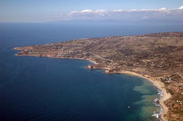
The Palos Verdes Peninsula and the Los Angeles basin were once completely covered by the ocean, so that the coastline was at the edge of the San Gabriel Mountains. Palos Verdes first rose up out of the sea about one million years ago. At that time water surrounded Palos Verdes on all sides, making it an island. If you stood at the edge of the San Gabriel Mountains, Palos Verdes Island would have looked like Catalina Island does today. While the island of Palos Verdes continued rising higher up out of the ocean, sediments washed down from the mountains, gradually filling the basin between the mountains and the island. Palos Verdes eventually became connected to the mainland when the basin, or low area, was filled to above sea level and became land. Today, we call the wide, lowlying stretch of land between the San Gabriel Mountains and the sea the Los Angeles Basin.
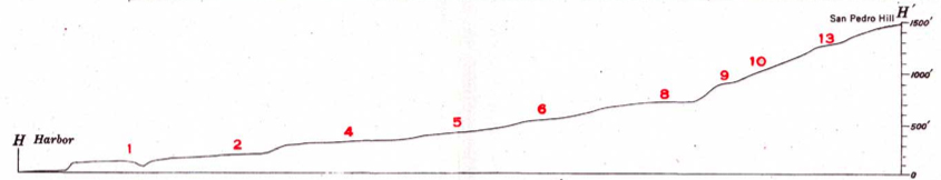
The Palos Verdes Peninsula still continues to rise slowly, about one foot every thousand years. The Peninsula has a “stair step” shape. The flat part of each step is called a marine terrace.
Marine terraces are characteristic of an exposed, windward coast where waves pound against the shore, cutting a vertical cliff face over time. The surging ocean then planes smooth the sea floor at the base of the cliff, forming the flat step of the wave-cut platform. The existence of several terrace levels at one coastal site is evidence of the long-term geologic processes affecting the California coast. Between one and two million years ago the oldest and highest terraces were uplifted by the same mountain-building process that created the Coast Mountain Ranges.

The most extensive marine terraces along the California coast are exposed along the sides of the Palos Verdes Hills in Los Angeles County, where a series of thirteen terraces rises to 1,300 feet above sea level.
The flat reef that extends off the end of the point is currently being eroded but will some day probably be uplifed to form a new terrace.
|
Terrace
|
Estimated age (ka) *
|
|
1
|
80
|
|
2
|
125
|
|
3
|
190
|
|
4
|
240
|
|
5
|
280
|
|
6
|
340
|
|
7
|
400
|
|
8
|
480
|
|
9
|
520
|
|
10
|
615
|
|
11
|
690
|
|
12
|
780
|
|
* ka = 1000
|
Logging requirement:
Once you get to the coordinates look northwest at the Palos Verdes coastline. Tell me in an email how many terraces you see – HINT: it’s not 13.
Other Links:
http://www.cnsm.csulb.edu/departments/geology/people/bperry/AerialPhotosSoCal/AerialPhotographyIndexMapPage.htm
http://seis.natsci.csulb.edu/VIRTUAL_FIELD/Palos_Verdes/pvmain.htm
http://www.pvplc.org
Bibliography
Point Vicente Interpretive Center. Palos Verdes Peninsula Geology.
Shlemon, R.J., 2007b, Marine terraces of the Palos Verdes Hills: The geomorphic legacy of glacio-eustacy and neotectonics: in Brown, A.R., Shlemon, R.J., and Cooper, J.D., eds., Geology and Paleontology of Palos Verdes Hills, California: A 60th Anniversary Revisit to Commemorate the 1946 Publication of U.S. Geological Survey Professional Paper 207: Pacific Section, Society for Sedimentary Geology (SEPM), book 103, p. 171-188
Woodring, W.P., M.N. Bramlette, and W.S.W. Kew, 1946, Geology and paleontology of Palos Verdes Hills, California. U.S. Geol. Surv., Prof. Paper 207: 145 p., 16 figs., 37 pls.