The Woodford State Fish and Wildlife Park is a 2,900-acre site, of which 2,462-acres are water. This area is also a favorite stopping point for waterfowl during migration. In the late 1970's the shift from manufacturing to service industries in Woodford County was partially addressed by creating this manmade channel along a known artesian acquifer to attact more sportsmen and their dollars. Well pipes were drilled in parallel along a manmade channel into the acquifer below. The artesian wells filled the channel and now provide year round fishing. During high water levels the wells are evidenced by ripples on the surface of the channel. When the water is low, you will see artesian springs flowing from a whole series of pipes.
Here is a short lesson on artesian acqifers. Some water underlies the Earth's surface almost everywhere, beneath hills, mountains, plains, and deserts. It is not always accessible, or fresh enough for use without treatment, and it's sometimes difficult to locate or to measure and describe. This water may occur close to the land surface, as in a marsh, or it may lie many hundreds of feet below the surface, as in some arid areas of the West. Water at very shallow depths might be just a few hours old; at moderate depth, it may be 100 years old; and at great depth or after having flowed long distances from places of entry, water may be several thousands of years old. Ground water is stored in, and moves slowly through, moderately to highly permeable rocks called aquifers. The word aquifer comes from the two Latin words, aqua, or water, and ferre, to bear or carry. Aquifers literally carry water underground. An aquifer may be a layer of gravel or sand, a layer of sandstone or cavernous limestone, a rubbly top or base of lava flows, or even a large body of massive rock, such as fractured granite, that has sizable openings. In terms of storage, at any one instant in time, ground water is the largest single supply of fresh water available for use by humans.,
Picture of Water cycle 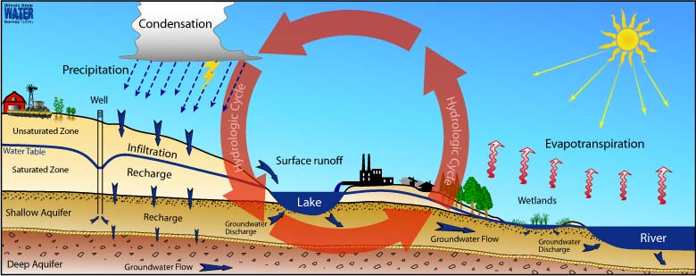
It is difficult to visualize water underground. Some people believe that ground water collects in underground lakes or flows in underground rivers. In fact, ground water is simply the subsurface water that fully saturates pores or cracks in soils and rocks. Ground water is replenished by precipitation and, depending on the local climate and geology, is unevenly distributed in both quantity and quality. When rain falls or snow melts, some of the water evaporates, some is transpired by plants, some flows overland and collects in streams, and some infiltrates into the pores or cracks of the soil and rocks. The first water that enters the soil replaces water that has been evaporated or used by plants during a preceding dry period. Between the land surface and the aquifer water is a zone that hydrologists call the unsaturated zone. In this unsaturated zone, there usually is at least a little water, mostly in smaller openings of the soil and rock; the larger openings usually contain air instead of water. After a significant rain, the zone may be almost saturated; after a long dry spell, it may be almost dry. Some water is held in the unsaturated zone by molecular attraction, and it will not flow toward or enter a well. Similar forces hold enough water in a wet towel to make it feel damp after it has stopped dripping.

Definitions of key Terms:
Spring - Area where there is a concentrated discharge of ground water that flows at the ground surface.
Unconfined Aquifer - Aquifer whose upper surface is a water table free to fluctuate. Unconfined aquifers do not have internal pressure (called artesian pressure), so if you drill a well into it, the water will only rise in the well casing up to the top of the aquifer (the water table); you will need a pump to get the water to the surface.
Unsaturated zone - A subsurface zone above the water table where the pore spaces may contain a combination of air and water.
Water table - The top water surface of an unconfined aquifer at atmospheric pressure.
Artesian Aquifer - Aquifer in which ground water is “confined” under pressure that is significantly greater than atmospheric pressure. It has an impermeable layer above and below it. This causes the aquifer to be under pressure. In a confined aquifer if you drill a well, the pressure will push water up the well casing; sometimes all the way to the land surface—no pump is needed! Note: While it is true that artesian water, or even just "plain" well water can sometimes be used directly for bottled water, this statement is false, because artesian water is not defined as being naturally filtered. A simple definition of artesian water is that it is water in the ground that is under pressure.
Aquifer - A geologic formation, group of formations, or part of a formation that contains sufficient saturated permeable material to yield significant quantities of water to springs and wells.
Ground water - In the broadest sense, all subsurface water; more commonly that part of the subsurface water in the saturated zone.
The Water Cycle - Is a process which consists of evaporation, transpiration, condensation, and precipitation. The whole process is controlled by the sun, which produces kinetic energy or heat energy. Deep wells drilled into rock to intersect the water table and reaching far below it are often called artesian wells in ordinary conversation, but this is not necessarily a correct use of the term. Such deep wells may be just like ordinary, shallower wells; great depth alone does not automatically make them artesian wells. The word artesian, properly used, refers to situations where the water is confined under pressure below layers of relatively impermeable rock. Where ground water is not confined under pressure, it is described as being under water-table conditions. Water-table aquifers generally are recharged locally, and water tables in shallow aquifers may fluctuate up and down directly in unison with precipitation or streamflow.
To log this cache you must correctly answer the following questions and take a picture of yourself or your GPS in front of the manmade channel containing the artesian springs. Please no spoilers.
1. As you appoach the manmade channel you will see a 15mph speed limit sign. On the same sign post is a small blue sign with three numbers on top. What are those numbers?
2. The Water Cycle is a process which consists of what four steps?
3. The water table is the altitude (below ground) where the water level in a well will rise to when the well taps a confined aquifer. Is this True or False? Hint: Read carefully.
4. Bottled water often is advertised as "artesian well water." Artesian water is ground water that is naturally filtered by an aquifer composed of fine, porous material—this artesian water can be put directly into bottles. True or False? Why?
5. From the given coordinates, determine the distance across the manmade channel.
Logs without pictures will be deleted without notice.