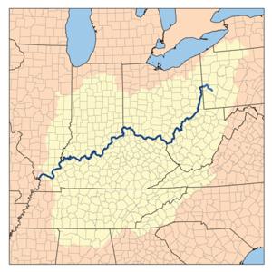
The Ohio Valley is a sub region in Kentucky running 658
miles long including parts of 25 counties and across five regions
of the state. Over 45% of Kentucky's population live in counties
the border the Ohio River, although those counties are only 16% of
the state's land area.
The Ohio Valley in Eastern and Northern Kentucky:

The physical characteristics of the Ohio River valley changes
very little from its beginning in downtown Pittsburgh,
Pennsylvania to just northeast of Louisville, including
the section that flows through a small part of the Cumberland
Plateau and the Eden Shale hill region of Northern Kentucky.
Throughout that entire stretch the river is contained in a very
narrow valley bounded by hills that are from 100 to 400 feet tall
and have an average angle of 45 degrees. The river ranges in width
in this stretch from around 1/4 of a mile to over 4/10 of a
mile.
The Ohio Valley in the Louisville Area:
The Ohio Valley changes dramatically around Louisville, as for
the first time heading downstream there are no bluffs overlooking
the river The river itself gets much wider and shallower, from 4/10
of a mile wide to over 9/10 a mile wide at the canal entrance, then
narrows to less than 3/10 of a mile downstream of the falls as it
approaches the Falls of the Ohio, the only natural obstacle along
the entire river. The falls were created by very hard coral rock,
which the river hasn't been able to erode. The coral contains many
visible fossils.

The flood plain through this stretch is very wide and flat,
extending 10 miles out on the Kentucky side and four miles on the
Indiana side, both east of the Muldraugh Escarpment. Also known as
Muldraugh Hill, it divides the Bluegrass and Pennyroyal Plateau
Regions in Kentucky, and the "karst plateau" in Indiana. The 400
feet tall hill is very visible in most parts of Louisville and
provides a scenic backdrop for the city.
From Muldraugh Hill to Owensboro:
At West Point, Kentucky the river the river crosses the
Muldraugh escarpment and is now bounded on both sides by the
largest bluffs along its entire length. The bluffs here range from
400-500 feet feet and in many places are almost vertical, although
the flood plain is about twice as wide as in Northern Kentucky. The
river here averges around 4/10 of a mile wide.
From Owensboro to the Mississippi River:
Starting near Rockport, Indiana the bluffs above the river
reduce greatly to 60 feet or less as the river enters a much
flatter region. The river itself becomes much more like the
Mississippi River in character, widening from around 1/2 a mile
wide in the West Point stretch to over 8/10 of a mile, and with
many more islands and oxbow lakes. This stretch of the river has 35
islands. many of the oxbow lakes in this stretch have been made
into wildlife management areas mostly for waterfowl, including the
Ballard WMA which is the state's largest.
The coordinate for this cache brought you to an
observation point with a beautiful view of the narrowest section of
the Ohio River Valley at West Point, Ky.
To log the find, please do the following:
Take a photo of yourself (optional) or your GPSr with the
Ohio River Valley as a backdrop.
To demonstrate the educational value of this Earthcache email
answers to the following three questions to me:
1. How long, in miles, is the Ohio Valley?
2. What is the average width of the Ohio river here at West
Point?
3. There are soldiers permanently 'stationed' here. Where are
they from?
Please email your answers to ARF! at this
address:
AirRaidFan@aol.com
Please email your answers first, the LOG THE FIND. Do not
wait on a reply from me. FINDs which do not meet logging
requirements will be deleted.

 Bronze.
 Silver.
 Gold.
Gold. Platinum.
ARF! is an EarthCache Master
You can be, too! Click on the Earthcache logo above to see
how!
Platinum.
ARF! is an EarthCache Master
You can be, too! Click on the Earthcache logo above to see
how!
Earthcaching: Leave No Trace!