Mount Riga State Park
Salisbury, Connecticut
Mt. Riga State Park is one of Connecticut’s undeveloped state
parks. Public access is on CT RT 41 North of Salisbury. The
Undermountain Trail, is the only public trail in the park and is
used to access the Applachian Trail to the west.
The location below is in the parking lot off CT RT 41.
Purpose: This EarthCache is created by the Connecticut
Geological and Natural History Survey of the Department of
Environmental Protection. This is one in a series of EarthCache
sites designed to promote an understanding of the geological and
biological wealth of the State of Connecticut.
Supplies: You will need to bring this write up, a gps
unit a way to take photos and water. Spoilers may be included in
the descriptions or links.
Directions: Public access is on CT RT 41 North of
Salisbury. The Undermountain Trail, is the only public trail in the
park and is used to access the Applachian Trail to the west. The
location below is in the parking lot off CT RT 41.
N. 42o01.728' W. –073o 25.733'
This Earthcache is a strenuous hike in some very pretty woods in
western Connecticut. It is 1.9 miles one-way and involves mostly
uphill hiking on the way in. The highway trailhead has an elevation
of about 750’ above sea level. The junction with the Appalachian
Trail is at an elevation of about 1750’. There is very little ledge
to see. Nonetheless, the geology of the area is interesting
The avid hikers can extend their treck by following the
Appalachian Trail north to the top of Bear Mountain. It is the
highest peak in Connecticut (elevation 2316’) although not the
highest point in Connecticut. The highest point elevation in
Connecticut is on the flank of Mt. Frissell at 2354’. A hike to the
top of Bear Mountain adds about another mile, one-way. The interest
hiker may wish to read a section on Mt. Riga State Park in Joseph
Leary’s book, A Shared Landscape, pp. 203-204 (see reference
below).
Looking at the topographic map, one can see several distinct
regions: the lowland areas to the east, an area of steep slopes,
and, to the west, an upland area on which two mountain peaks
protrude. As you walk up the hill, keep thinking, there is a
geologic reason for this. Unfortunately few rock outcrops are seen
along the trail to verify this assertion.
The lowland areas have an elevation roughly around 700 above sea
level. These areas are underlain by marble and calcium-bearing
gneiss and schist. Geologists refer to this rock formation as
Stockbridge Marble. It was deposited as limestone around
500-million years ago and then was metamorphosed into marble when
the Appalachian Mountains were being formed.
Marble is particularly susceptible to dissolution in acidic
waters. Perhaps you may remember seeing, in an old graveyard,
marble headstones whose lettering has been rendered illegible by
the ravages of weathering. The gravestone weathering was caused by
dissolution in rainwater that is naturally slightly acidic. The
same process has affected natural areas where the bedrock consists
of marble or calcium-bearing schist and gneiss. Over the millennia
rock has dissolved in rainwater or groundwater, creating the
lowlands seen today. We refer to these lowlands as marble valleys.
To the east, the Housatonic River flows in a marble valley over a
good part of its course.
The slopes on the side of the valley, and some of the small
hills within the valley, are underlain gray schist (and locally,
gneiss) of the Walloomsac Schist. The schist is younger than the
marble and overlies it. It is of Ordovician age (~475 million years
ago). The Walloomsac schist is more resistant to erosion than
marble.
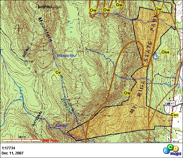
Topographic map (C.I.=20’) of the Mt. Riga area showing
boundaries of bedrock formations. Csc and Ose are the Stockbridge
Marble, Ow is the Walloomsac Schist, and Ce is Everett Schist.
Heavy line separating Everett Schist from other formations is
interpreted to be a fault surface. After Rodgers, 1985.
In some nearby areas, the Walloomsac Schist and the upper part
of the Stockbridge Marble locally contain concentrations of iron
ore minerals. The ore minerals are various iron oxides, including
limonite (Fe(OH)2) and hematite
(Fe2O3). Mining of these ores began during
colonial times and continued until the early part of the
20th century (Pawloski, 2006). Most were mined by
digging a large open pit and hauling the ore over the top and to a
nearby furnace.1 Two old iron mines are noted on the
“Mine-map” of Connecticut (Altamura,
1. The interested cacher may wish to visit the nearby Beckley
Furnace Industrial Park located a few miles to the east.
Information can be found at: Beckley Blast Furnace
htt
p://www.geocaching.com/seek/cache_details.aspx?guid=9256967a-9c84-460a-ac5c-0bf9e162bb76.
1987), one just south of the State Park (Clark Mine; Hobbs,
1907, p.156) and the other near the eastern boundary of the State
Park across from Fisher Pond (Scovill Mine; Hobbs, op.
cit.). Neither was a large enough operation to have resulted in
pits of sufficient size to show-up on current topographic maps
(scars on the topography left from old open-pit mines are readily
apparent in the Lakeville area to the south). Neither sites have
been located.
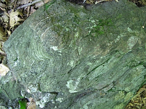
The highland areas are underlain by an older rock, the Everett
Schist. It is lighter colored than the Walloomsac Schist and
slightly coarser-grained. It formed about 500-million years ago.
The Everett Schist forms outcrops along the almost north-south
mountain escarpment and it underlies all of the uplands above the
scarp. Where the Undermountain Trail crosses the escarpment,
Everett Schist crops out. They are the only outcrops found of this
trail. They are gray somewhat gneissic schist that is highly
contorted and folded (see picture below).
Contorted layers seen in a boulder of the Everett Schist near
base of cliff. View shows about 2 feet of
boulder. |
|
The forming of the Everett Schist and its relation to the
Stockbridge and Walloomsac rock units is an interesting story. Five
hundred million years ago the edge of the North American continent
in western Connecticut (see Rodgers, 1985 and Coleman, 2004). In
southwestern Connecticut the continental margin was located in the
Danbury area and in northwestern Connecticut it was located near
the Barkhamsted reservoirs. Limestone, which later was
metamorphosed to marble, formed on top of the continental shelf.
The distribution of marble is one of the tools geologists use to
interpret where the edge of the continent was. The Everett Schist
was originally formed by deposition of mud on the seaward slopes of
the continental margin, east of the continental shelf edge. The mud
later was metamorphosed into schist. How that schist came to be on
top of the continental margin limestone/marble and to its west is
the interesting part.
The initial pulse of mountain building that would ultimately
lead to the rise of the Appalachian Mountain chain began about 440
million years ago (see Coleman, 2005). At that time plate tectonic
processes caused a small island archipelago (or maybe several) to
“smush” into North America, or perhaps vice versa. As this was
happening, the continental shelf buckled downward and mud, that
eventually would form the Walloomsac schist, was deposited over the
lime. As a result of this collision large slices of the continental
slope sediments sheared off and were thrust up and onto the
continental shelf. The thrusting was possibly aided by
water-saturated Walloomsac-muds acting as a slippery base over
which the slices could slide. Thus, today we see the older Everett
Schist lying on top of the Walloomsac Schist and Stockbridge
Marble. It records the first phase of the building the Appalachian
Mountains, which would last another 200 million years or so.
The latest period of geologic history occurred during the last
Ice Age, a mere 20,000-25,000 years ago, and the meltdown of the
glacial ice, which began about 17,500 years ago in southern
Connecticut but around 15,500 years ago in this area.
The ice was as much as 1.5-2 km thick at the height of the last
ice age. Ice that thick is relatively weak and it flows from areas
where the ice is thicker (north) to areas where the ice is thinner
(south). It extended from northern Canada to as far south as Long
Island. Its maximum extent occurred 22,000 to 20,000 years ago.
After that time global climate warmed and the great glacier began
melting. The climate was warmer to the south (as it is today) and
the glacier was thinner in the south; thus, the southern end of the
glacier melted northward. About 15,500 years ago the ice melted
back (north) far enough that the Mt. Riga area was ice free. Ice
persisted in the valleys a little longer.
As ice flows, it bulldozes the soil and scrapes the rock on
which it rides, causing erosion. It also moves all the debris it
erodes. When riding over hills or mountains, the ice melts slightly
at its base on the uphill side and then refreezes when it crosses
the crest of the hill or mountain. Some of the melt-water seeps
into cracks in the rock and refreezes. This action may cause blocks
of the rock to break off the ledge and then to be carried away in
the base of the glacier. Large blocks of rock, frozen into the base
of the glacier can gouge the underlying rock, causing even more
erosion. All the glacial processes resulted in a smoothing of the
landscape to what we see today.
Activity 1: As you hike along the trail, find you way to the
following location,
N. 42o 01.877' W. -073o 26.379'and
consider the following.
This location is off the trail to the north. Be careful and
watch your footing. A cliff will be visible and near its base you
will find numerous blocks of fallen rock and, immediately at the
foot of the cliff, a talus slope. Observe the blocks that rolled
beyond the talus slope. Some are large and some are not so large.
What is most interesting is that they seem to have rolled, large
and small alike, just so far. One could almost draw a line in the
soil beyond which the rocks are not found. The question is whether
this observation in real or imagined? This site was visited in mid
June and again in late November. To find these sizes grouped
together was not expected. One would expect larger rocks to roll
farther after they are dislodged from the cliff and smaller rocks
to stop closer to the cliff base. This is because the larger blocks
will have greater momentum than the smaller ones. If both large and
small roll the same distance, we need an explanation.
If the observation is valid then there are several questions to
ask and answer. Foremost, when did the rocks fall? If it were after
all the ice melted one would expect heavier rocks to roll farther
than lighter ones. The rocks would not have fallen during the
height of glaciation because ice would have carried them off.
Indeed, during the height of glaciation the cliff was surrounded by
ice and the rocks could not fall. Once cracked from the ledge they
were
All pictures taken in vicinity of GPS location given
above. Left picture taken standing at lower edge of boulders
looking upslope. Dense boulder field upslope abruptly ends where
picture was taken. Middle picture shows mid-slope edge of boulder
field a s hort distance toward the northeast; large boulders end at
a line that could be drawn from left-center of picture going
diagonally across picture in uphill direction. Some small cobbles
persist down slope. The density of the cobble population is normal
for the till in the area. Picture to right shows view looking
toward west. Left third of this view is boulder free; right side,
going uphill, contains abundant boulders.
simply engulfed by ice and carried off. They must have fallen
near the end of the glacial age when ice was thinning. Possibly a
small ice cave developed next to the cliff caused by ice flowing
over the top of the cliff and not reattaching itself to the ground
for a few tens of feet beyond the cliff. Or possibly there was a
crevasse that developed just south of the cliff after ice movement
ceased. The point is that there must have been a mass of ice south
of the cliff that stopped large and small blocks alike and, hence,
a line beyond which falling rock did not roll.
This is an interesting problem because several other locations
in Connecticut where, “downstream” (relative to the flow direction
of the ice) from prominent cliffs there are distinct fields of
boulders that have sharp boundaries beyond which the boulders did
not roll. At the end of this EarthCache you are asked to send your
observations and thoughts on the problem.
Activity 2. Proceed to N. 42o 02.095'
W.-073o 27.280'which should be at the intersection of
the Undermountain Trail with the Appalachian Trail, and take a
picture showing you or your companions next to the sign.
The Appalachian Trail heads north and ascends Bear Mountain
about a mile farther north. Leary (2004) reports a magnificent view
from the top of Bear Mountain.
How do people respond to this EarthCache? See activity 2.
Send picture for credit to the Cache manager along with a copy of
your observations from activity one.
Difficulty: 2
Terrain: 3.5
Type of land: State Park
EarthCache category: Glacial geology and geologic
history.
References:
Altamura, R.J., compiler, 1987, Bedrock Mines and Quarries of
Connecticut, with citation
list and references cited. State Geol. and Nat’l Hist. Surv. of
Connecticut, CT Atlas Series, 1:125,000.
Coleman, M. E., 2005, The Geologic History of Connecticut’s
Bedrock. State Geol. and
Nat’l. Hist. Surv. of Connecticut, Spec Pub. #2, 30p.
Hobbs, W.H., 1907, The iron ores of the Salisbury District of
Connecticut, New York, and Massachusetts. Economic Geology v.
2:153-181.
Leary, Joseph, 2004, A Shared Landscape: A Guide and History
of Connecticut’s State Parks and Forests. Friends of CT State
Parks, Inc. 240p. May be purchased at the DEP Store, Hartford
CT.
Palowski, J. A., 2006, Connecticut Mining. Arcadia
Publishing, Charleston, SC, 127p.
Rodgers, John, 1985, Bedrock Geological Map of
Connecticut. State Geological and Natural
History Survey of Connecticut, Nat’l. Resource Atlas Series,
1:125,000
<