Whitesburg Weir Dam EarthCache
-
Difficulty:
-

-
Terrain:
-
Size:  (not chosen)
Please note Use of geocaching.com services is subject to the terms and conditions
in our disclaimer.
This Earthcache is located in Whitesburg, KY. You can access taking
US 119 to the Whitesburg City Park. Once at the park you drive
straight to the dam. The dam is also located beside the Whitesburg
water treatment plant.
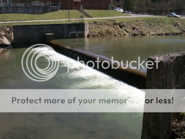
A weir (also known as a lowhead dam) is a small overflow-type dam
commonly used to raise the level of a river or stream. Water flows
over the top of a weir, although some weirs have sluice gates which
release water at a level below the top of the weir. The crest of an
overflow spillway on a large dam is often called a weir.
A weir may be used to maintain the vertical profile of a stream or
channel, and is then commonly referred to as a grade stabilizer.
While a weir will typically increase the oxygen content of the
water as it passes over the crest, a weir can have a detrimental
effect on the local ecology of a river system. A weir will
artificially reduce the upstream water velocity which can lead to
an increase in siltation. The weir may pose a barrier to migrating
fish. Fish ladders provide a way for fish to get between the water
levels.
- Sharp Crested Weir
- Broad Crested Weir
- Crump Weir
- Proportional Weir
- Combination Weir
The North Fork of the Kentucky River
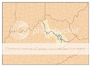
The North Fork of the Kentucky River originates in the mountains of
southeastern Kentucky near Whitesburg and flows northwest, draining
the counties of Letcher, Perry, Breathitt, and Lee. It is
approximately 125 miles long and rises on the western side of Pine
Mountain, in the Appalachians of extreme southeastern Kentucky, in
eastern Letcher County near the Virginia state line. It flows
generally northwest, in a winding course through the Cumberland
Plateau, past Hazard and Jackson. It receives Rockhouse Creek at
Blackey near its source. Approximately 8 miles southeast of Hazard,
it receives Carr Fork Lake. Three miles upstream from its
confluence with the South Fork, it receives the Middle Fork. It
joins the South Fork to form the Kentucky at Beattyville.
The logging requirements for this Earthcache are: 1. Estimate the
length of the dam 2. Estimate the difference in the level of the
river 3. Post a picture yourself and your GPSr with the dam in the
background.
Additional Hints
(No hints available.)