
To Claim This Earthcache
-
What type of aquifer is the Spokane Valley-Rathdrum Prairie Aquifer?
-
The valley above the Aquifer covers approximately how many miles in Idaho, including the Rathdrum Prairie, and in Washington, including the Spokane Valley?
-
Approximately how many gallons is the capacity of the Spokane Valley-Rathdrum Prairie Aquifer?
-
How long does it take for a contaminant on the surface to reach the Spokane Valley-Rathdrum Prairie Aquifer?
- Visit Sullivan park located at the Earthcache coordinates. You can see many big boulders like the kind in the Aquifer along the Spokane River south of the parking lot. Take a picture of yourself next a large boulder (like one found in the aquifer) and/or other materials found inside the Aquifer.
- Send answers to questions 1-4 to geothreebottles@gmail.com and post your picture on this Earthcache page. If you are unable to complete step #5 listed above please contact us and we'll work with to find an alternative site to visit.
Sullivan Park is just north of the river on the west side of Sullivan Road. You can see many big boulders like the kind in the Aquifer along the Spokane River at Sullivan Park. When the Spokane River is low, springs are visible around the Sullivan Road bridge pilings. This is water from the Aquifer flowing into the river.
What is an Aquifer?
An aquifer is a saturated underground rock layer with enough available water that can be pumped out or flow from the ground as a spring. Certain areas of the U.S. have aquifers that are constantly replenished by way of the hydrologic cycle.
Scientists who study groundwater (often called “hydrologists” or “hydrogeologists”) generally distinguish between two types of aquifers:
|
|
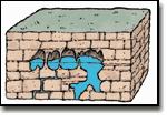
Porous media aquifers
|
|
Porous media aquifers consist of individual particles the size of sand or gravel and up to large boulders. Groundwater moves through the openings, between the individual grains or rocks, called pore spaces.
Consolidated sediment aquifers are porous rock layers where grains are cemented to each other. Sandstones are examples of consolidated porous material.

Unsolidated sediment aquifers contain sediments that are loose, un-cemented particles—such as sand, gravel, clay, or silt—that have not been transformed into rock through lithification. These materials are typically found on the surface, often deposited by water, wind, or glaciers, and are characterized by high porosity, allowing them to act as aquifers.

The Rathdrum Prairie-Spokane Aquifer is an unsolidated sediment aquifer.
|
|
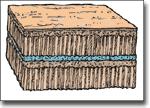
Fractured aquifers
Fractured aquifers consist of solid rock layer where groundwater is found in fractures, joints or cracks in the rock. Fractured aquifers can be found in many different types of rocks including granite and basalt.
|
Limestone aquifer |
Basalt aquifer |

Typical fractured aquifer |
| |
|
|
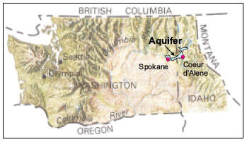
The Spokane Valley-Rathdrum Prairie Aquifer
The sole source of water for most of the people in Spokane County, Washington and Kootenai County, Idaho is a high quality underground water body called the Spokane Valley-Rathdrum Prairie Aquifer. Discovered in 1895, this Aquifer has become one of the most important resources in the region, supplying drinking water to more than 400,000 people. The Aquifer has been studied in considerable detail since 1977, and the results of these investigations have produced programs and regulations designed to insure this aquifer will remain a valued and protected resource for future generations.
Aquifer Formation

The Spokane Valley and Rathdrum Prairie are ancient geologic features that have, for millions of years, been slowly formed by water flowing towards the Pacific Ocean. During the last Glacial Age, between 12,000 and 1.6 million years ago, a series of catastrophic floods covered this area as a result of the rapid draining of ancient Lake Missoula in Montana when ice dams broke. These floods deposited thick layers of coarse sediments (gravels, cobbles, and boulders) in this area. The saturated portion of these sediments, where void spaces are filled with water, comprises the Aquifer. Waters from adjacent lakes, mountain streams, the Spokane River and precipitation flow through the flood sediments replenishing the Aquifer.
Location and Flow
The Aquifer begins in Idaho between Spirit Lake and the south end of Lake Pend Oreille. The Aquifer water flows south until it reaches the middle of the Rathdrum Prairie, then it turns west and flows into Washington under the Spokane Valley. When the Aquifer water reaches downtown Spokane, most of it turns north, flows under the city and discharges into the Little Spokane River.
Above The Aquifer
The Spokane Valley-Rathdrum Prairie Aquifer flows beneath a broad valley that slopes downward from Lake Pend Oreille to downtown Spokane losing almost 700 feet in elevation. The basalt formation that forms Spokane Falls diverts the Aquifer to turn north after downtown Spokane. In the north, Five-mile Prairie splits the valley and the Aquifer flow north from downtown Spokane with the Hillyard Trough to the east and the valley along the Spokane River to the west. The land surface in north Spokane is higher than in downtown Spokane and the lowest part of the valley above the Aquifer occurs at the confluence of the Spokane and Little Spokane Rivers. In general, the higher the surface elevation, the greater the depth to the Aquifer. The valley above the Aquifer covers approximately 202 square miles in Idaho, including the Rathdrum Prairie, and 120 square miles in Washington, including the Spokane Valley.
Edges of the Aquifer
The valley walls are made up of rocks and clay that continue below the ground surface to form the edges of the Aquifer. Relatively flat basalt plateaus such as Five-mile Prairie and the Columbia Plateau rise hundreds of feet above the valley. The Bitterroot Mountains east of Rathdrum Prairie and the Selkirk Mountains along the Washington - Idaho border form other Aquifer edges. These mountains are over 2000 feet higher than the basalt plateau to the southwest so clouds carried by the prevailing southwesterly winds must rise when they reach the mountains. As the clouds climb they release more precipitation, often as snow which provides significant recharge to the Aquifer during the spring.
Surface Water
Several lakes are situated in the mountains around the borders of the Aquifer. The two largest lakes, Pend Oreille and Coeur d’Alene, fill deep troughs and contribute water to the Aquifer through subsurface flow. The surface outlet for Lake Pend Oreille is the Pend Oreille River that drains to the north, away from the Aquifer. The surface outlet for Lake Coeur d’Alene is the Spokane River, which is the only watercourse over the Aquifer that remains on the surface for an extended distance. The only streams that reach the Spokane River flow very short distances over the Aquifer. All of the other streams flowing out of the surrounding highlands into the valley and all of the other lake outlets sink into the coarse, gravelly soils to recharge the Aquifer.
Geology
The Spokane Valley-Rathdrum Prairie Aquifer area contains richly varied and interesting geology. The geologic history of this area includes ancient mountain building, spectacular basalt lava flows, and some of the largest known glacial outburst floods.
Geologists use the geologic time scale to place events in geologic history. This time scale was developed through age dating and fossil correlation. Geologic time is organized into four “Eras” and numerous “Periods”, as shown on the map key on this page. Three major geologic events define the creation of the Spokane Valley-Rathdrum Prairie Aquifer. The first event was the emplacement, metamorphism, and erosion of the Precambrian basement rock; the second event was the eruption of Tertiary (Miocene) flood basalts that created the Columbia Plateau; and, the third event was the glaciation in the Quaternary Period that first eroded, then filled the Spokane Valley-Rathdrum Prairie area with coarse sediments and gravel to create the Aquifer.
Basalt Flows
Spokane and Coeur d’Alene are situated on the eastern edge of the Columbia Plateau. Many of the largest lava flows in the Columbia Plateau erupted about 135 miles southwest of the Aquifer. Extraordinarily fluid lava flows extended northward past the present location of Spokane and into Idaho. The remnants of these flows are found in and around the Spokane Valley. Basalt is a dense dark rock with very fine crystals, and it sometimes has a unique hexagonal (six-sided) column-like appearance. The Columbia basalts in the Spokane-Rathdrum valley were eroded prior to the formation of the Aquifer, and now only the western portion of the Aquifer lies on Columbia basalts.
Glaciation
Geologic evidence suggests two Ice Ages have left a clear record in the landscape of the northern Rocky Mountains. The exact time of the first Ice Age is unknown, but likely occurred about 100,000 years ago. The most recent Ice Age climaxed about 15,000 years ago and ended approximately 10,000 years ago (see Back Cover). Evidence of other ice ages older than 100,000 years have nearly disappeared from the landscape, but occasional patches of glacial sediment attest to their existence. During both Ice Ages, glaciers covered most of British Columbia and moved south into northern Idaho and Washington, filling the valleys and covering all but the higher mountains. Those higher mountains also supported glaciers that flowed down the valleys to join the regional ice. In the broad valleys of northern Idaho, the main evidence of both ice ages is found in widespread deposits of glacial debris: till and outwash. However, more of these materials occur in the Spokane Valley and Rathdrum Prairie.
Glacial Till and Outwash
Glacial till is surface material pushed and carried by glacial ice: an unsorted and unlayered mixture of all sizes of sediment from clay to boulders. A till deposit is called a moraine, and moraines provide geologists with the location of ancient glacial ice. The most conspicuous and informative deposits of till are the morainal ridges that precisely outline the former boundaries of the glacier. Outwash is deposited from glacial meltwater, and it consists of neat layers of clay, sand, and gravel. A smooth blanket of outwash extends down slope from many moraines, evidence of the torrents of muddy meltwater that swept across those slopes during ice age summers. Since the last Ice Age ended, streams have entrenched themselves into most outwash deposits, exposing through erosion remnant benches along the stream course.
The Spokane Valley-Rathdrum Prairie Aquifer issues facing the region’s residents fall into two broad categories: water quantity and water quality.
Quantity Estimates
From its discovery over 100 years ago through the 1960s, the Aquifer was considered an “inexhaustible supply” of water. This is not true.
Water Withdrawal
Approximately 219 million gallons were withdrawn from the Aquifer to supply the domestic needs of the area’s residents on an average day in 1999. However, on hot summer days the added water use for irrigation increases the daily Aquifer water withdrawal to over 680 million gallons. The national average of water use per household is about 350 gallons per day, but in our region daily household use can be as high as 600 gallons per day. The region’s residents are fortunate that the Aquifer has a large storage capacity estimated to be approximately 10 trillion gallons.
Contamination Vulnerability
The Spokane Valley-Rathdrum Prairie Aquifer is highly vulnerable to contamination from activities on the ground surface. Unlike many other aquifers, the Aquifer does not have protective layers of clay to deter infiltration of surface contaminants. The soil layer on top of the Aquifer is relatively thin in most areas, and fluids readily infiltrate into the porous sands and gravel that comprise the aquifer soils. Potential contamination is perhaps the most important aquifer issue that must be addressed in order to preserve and maintain the Aquifer as a regional drinking water resource.
Contamination in the Aquifer
Unlike many other aquifers, the travel time for a contaminant on the surface to reach the Aquifer water table is usually a matter of hours or days, particularly for contaminants that are dissolved in water recharging the Aquifer. Once a contaminant enters the Aquifer it spreads into a plume, much like a plume of smoke from a smokestack. A contamination plume moves with the Aquifer flow as it gradually disperses. The process of dispersion causes the plume to spread both horizontally and vertically as it moves along with the aquifer flow. The contaminant concentration in the plume varies and tends to decrease along the edges of the plume as the contamination moves into uncontaminated water and becomes more dilute. As the plume grows and widens more Aquifer area becomes contaminated and the likelihood drinking water wells becoming contaminated increases. Different chemicals mixed with the water in the Aquifer create different plume behavior, and remedial actions must be customized to the specific contaminant. Contamination in the Aquifer may be cleaned-up, or remediated, but the clean-up process is usually costly.

Resources
Spokane Aquifer Organization
The Spokane Valley-Rathdrum Prairie Aquifer Atlas, 2000, Idaho Department of Environmental Quality and Spokane County Utilities Department