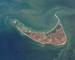
Nantucket is famous for its handmade baskets, as well as being a
tourist destination and summer colony. The population of the island
soars from approximately 10,000 to 50,000 during the summer months,
due to tourists and summer residents. According to Forbes Magazine,
in 2006, Nantucket had the highest median property value of any
Massachusetts zip code.
MOGA MMVIII (2008)
Welcome to Mark Twain Lake -
John F. Spalding Recreation Area.
John F. Spalding Recreation area is located
on the North side of Mark Twain Lake. This area has many different
attractions and a quiet, remote location. There are many
opportunities for hunting, hiking, fishing, horseback riding, or
bird watching.
(Source for information
can be found on the Clarence Cannon Dam
website.)
Out here, we have placed a number of caches
for your hunting pleasure. The area is accessible year round with
the exception of a special Handicap Hunt. During off season, you
must check in at the district office and let them know you are
hunting caches. Some areas of the recreation area can be gated so
you would have to park and walk in. Letting the office know will
prevent a meeting with a ranger and having to explain why you were
back there in the first place. During regular season, usually from
April - October, the area is wide open. Check the website for more
information. US Army Corps of
Engineers - Mark Twain Lake.
These caches were placed by Eagle Scouts Kyle
Jones and Kevin Linn, both from Troop 760, Boone Trails District,
Greater St. Louis Area Council. Please remember to trade up when
trading items. Check out the local businesses while in the area and
make sure you check out the South side of this beautiful
lake.
This cache is placed in the John
F. Spalding Recreation Area which is managed by the U.S. Army Corps
of Engineers, St. Louis District, Mark Twain Lake. A special thanks
to Allen Mehrer, USACOE Forester, who provided the Ammo Cans and
recommended where to hide them.