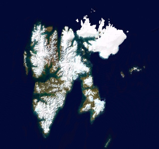
SVALBARD
Svalbard is an archipelago in the Arctic Ocean north of mainland
Europe, about midway between Norway and the North Pole. It consists
of a group of islands ranging from 74° to 81° North, and 10° to 35°
East. The archipelago is the northernmost part of the Kingdom of
Norway. Three islands are populated: Spitsbergen, Bjørnøya and
Hopen. The largest settlement is Longyearbyen. The Svalbard Treaty
recognises Norwegian sovereignty over Svalbard and the 1925
Svalbard Act makes Svalbard a full part of the Norwegian
Kingdom.
Vikings may have discovered Svalbard as early as the 12th
century. Traditional Norse accounts exist of a land known as
Svalbarð - literally "cold edge". (But this land might also have
been Jan Mayen, or a part of eastern Greenland.) The Dutchman
Willem Barents made the first indisputable discovery of Svalbard in
1596. The islands served as an international whaling base in the
17th and 18th centuries, when the Greenland whale was extirpated
from this region. From 1611 to 1720 whaling took place off the
western coast of Spitsbergen, by Basque, British, Danish, Dutch,
French, and Norwegian ships. It is estimated that the Dutch alone
took 60,000 whales from their base Smeerenburg. They also provided
the headquarters for many Arctic exploration expeditions.
At the beginning of the 20th century, American, British,
Swedish, Russian and Norwegian companies started coal mining.
Norway's sovereignty was recognized by the Svalbard Treaty of 1920
with an addition that there would be limited military use of
Svalbard and that the other nations retained the rights to their
settlements; five years later Norway officially took over the
territory. Some historians claim that Norway was given sovereignty
as compensation for its Merchant Fleet losses during World War I,
when the Norwegian Merchant fleet played an important role
supplying the UK. Only Norwegian and Russian settlements survived
[World War II].
From the late 1940s to the early 1980s the geology of the
Svalbard archipelago was investigated by teams from Cambridge
University and other universities (e.g., Oxford University), led by
Cambridge geologist W. Brian Harland. Many of the geographical
features of the isles are named after the participants in these
expeditions, or were given names by them linked to places in
Cambridge (see Norwegian Polar Institute).
The name of the largest island in the archipelago, Spitsbergen
(Dutch for "Jagged mountains") was formerly used to refer to the
entire archipelago, while the main island was called West
Spitsbergen.
SEED BANK!
The Norwegian government has built a "doomsday" seed bank to
store seeds from as many of the world's crop varieties and their
botanical wild relatives as possible. The bank was created by
hollowing out a 120-meter tunnel on Spitsbergen cut into rock with
a natural temperature of -6 degrees Celsius, refrigerating it to
-18 degrees Celsius, and then storing seeds donated by the 1,400
crop repositories maintained by countries around the world. The
vault has top security blast-proof doors and two airlocks. The
number of seeds stored depends on the number of countries
participating in the project. The point of this project is to
prevent the diversity of agricultural crops currently stored
(typically in the form of seed) in seed banks from becoming extinct
as a result of accident, mismanagement, equipment failure, war or
natural disaster, or due to a regional or global catastrophe.
Svalbard lies far north of the Arctic Circle. In Longyearbyen,
the midnight sun lasts from April 20 to August 26, and polar night
lasts from October 26 to February 15. From November 12 to the end
of January there is civil polar night, a continuous period without
any twilight bright enough to permit outdoor activities in the
absence of artificial light. The only other non-Inuit or research
settlement that has this phenomenon is Dikson near the mouth of the
Yenisey River in Russia.
In addition to humans, four predominantly terrestrial mammalian
species inhabit the archipelago: the Svalbard field mouse Microtus
epiroticus, the Arctic fox, the Svalbard reindeer (a distinct
sub-species), and polar bears. Since polar bears occur very
commonly on Svalbard and are known to hunt humans on occasion, all
people need to take precautions when outside the settlements: this
includes carrying a rifle. Nevertheless, the law protects polar
bears, forbidding anyone to harm or disturb them unless it is
necessary to remove a considerable danger of injury to a person. A
large number of aquatic mammalian species also inhabit the
archipelago, including whales, dolphins, seals and walruses.
Svalbard is also a breeding ground for large numbers of
seabirds, including Brunnich's and Black Guillemot, Puffin, Little
Auk, Fulmar and Black-legged Kittiwake. Other seabirds include
Arctic Tern, four species of skua, and the elusive Ivory Gull. The
Svalbard Ptarmigan, found on the larger islands, is the only land
bird present for the entire year. Only two songbirds migrate to
Svalbard to breed: the Snow Bunting and the Wheatear.
There is an astonishing variety of flowering plants on Svalbard.
Although they are very small, these plants use the short period of
24-hour daylight to produce colourful blossoms. See also: Flowers
of Svalbard.
Svalbard is part of the High Arctic Large Igneous Province.
MOGA MMVIII (2008)
Welcome to Mark Twain Lake -
John F. Spalding Recreation Area.
John F. Spalding Recreation area is located
on the North side of Mark Twain Lake. This area has many different
attractions and a quiet, remote location. There are many
opportunities for hunting, hiking, fishing, horseback riding, or
bird watching.
(Source for information
can be found on the Clarence Cannon Dam
website.)
Out here, we have placed a number of caches
for your hunting pleasure. The area is accessible year round with
the exception of a special Handicap Hunt. During off season, you
must check in at the district office and let them know you are
hunting caches. Some areas of the recreation area can be gated so
you would have to park and walk in. Letting the office know will
prevent a meeting with a ranger and having to explain why you were
back there in the first place. During regular season, usually from
April - October, the area is wide open. Check the website for more
information. US Army Corps of
Engineers - Mark Twain Lake.
These caches were placed by Eagle Scouts Kyle
Jones and Kevin Linn, both from Troop 760, Boone Trails District,
Greater St. Louis Area Council. Please remember to trade up when
trading items. Check out the local businesses while in the area and
make sure you check out the South side of this beautiful
lake.
This cache is placed in the John
F. Spalding Recreation Area which is managed by the U.S. Army Corps
of Engineers, St. Louis District, Mark Twain Lake. A special thanks
to Allen Mehrer, USACOE Forester, who provided the Ammo Cans and
recommended where to hide them.