GB: (CZ verze následuje)
The place I want to take you to today lies in the heart of the
Hostýnské hills. It is a place where I once enjoyed my first soup
cooked over a campfire and smelled the lovely tobacco fragrance
when some of the older ones filled their pipes and told stories
which may have been only half-true. Let’s go together where
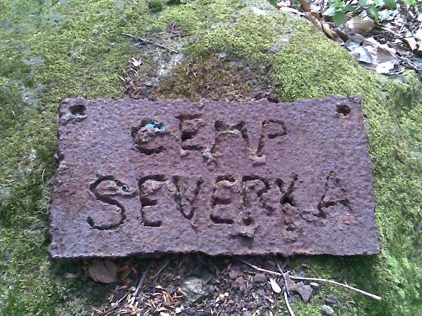
the campsite perhaps used to be. We used to call it Tramps of the
Round Table, but the sign you’ll find there now, says
“Camp Severka (=NorthStar)”.
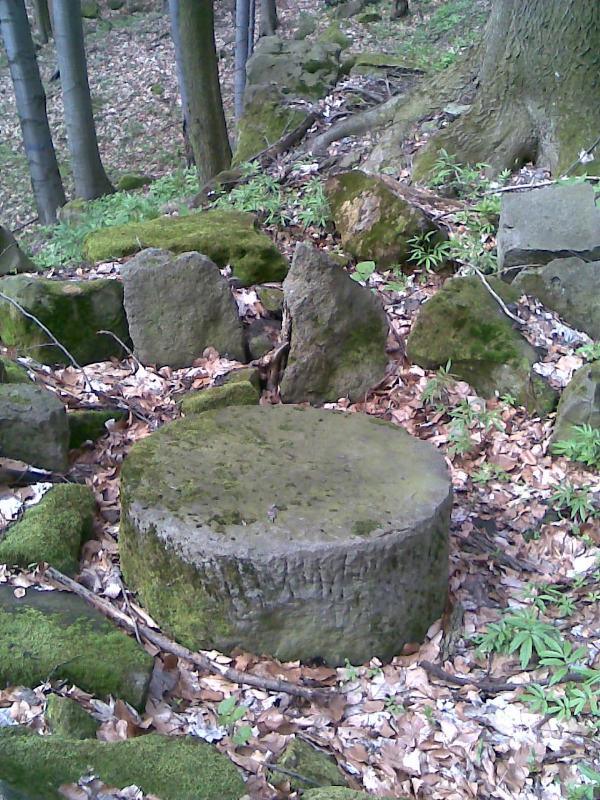
When you get to the cache coordinates, you’ll find
yourself standing in the middle of a ravine where you can climb
over a scree field, among smaller and bigger rocks or boulders
covered in moss, right up to the summit of Smrdutá Hill. The site
defined by these coordinates is interesting because of a forgotten
millstone, rediscovered by a group of friends who used to come here
camping and used it as a table, a round table. The millstone
wasn’t here just by coincidence, legends of the region say
that until the end of the nineteenth century, this site was a
source of material for stone-masons, who made millstones right
here, on the spot. Sometimes things didn’t work out right and
therefore you can still find a few more or less completed
stones.
However, this locality is mainly important in terms of flora,
fauna and geomorphology. The geological composition includes
sandstone, conglomerate and claystone of the “magurský
flysh” zone. In this area, there are bigger separate rock
formations, scree fields and pseudokarst fissure caves. They were
created by tectonic rupture of the sandstone and the subsequent
effect of frost and gravitational forces. These formations are of
two types: the fissure caves and the surface caverns in the
overhangs. A few fissure caves are in the very neighbourhood of the
cache, some of which provide a source of water for visitors. In one
of them, called Zamrzlá (Frozen Cave) ice can be found late into
springtime. In Smrdutá cave (Smelly Cave), white calc-sinter
coating has been found, resembling cauliflower – this is
called pea-grit or peastone. It is the result of chemical
precipitation of calcium carbonate which filled holes in the
ceiling of the cave to an area of appr. 1m2. The ground surface
mainly consists of cambisoils, and azonal type soil (typical and
cambic ranker) is developing within the nature reserve –
which was established here for this very reason in 1975. At present
it is one of the best-preserved localities within the Hostýnské
hills. For me, this was the reason to create a cearthache here.
Your task is to take a picture of yourself or your team, or even
your GPS, but always together with the described ROUND stone,
you’ll definitely recognize it. Your second task is to send
me an e-mail describing the symbol which is engraved on the table
(on my picture it has been erased). The area also has one other
interesting spot. It is an inconspicuous rock above the stream (the
second pair of coordinates) near to the recommended parking place.
If you climb on top of the rock, you will find the remains of a
stone building – not a castle, but a hunters’ lodge
which belonged to the Bystrice estate. Local people call this place
Liškárna (Fox’s Den). Count Rottal used to sit here,
in his lodge, and have the animals driven right in front of his
gun. A comfortable arrangement. Again, add a picture of the ruins
of the lodge to your log.
CZ: (po našem)
Místo, kam Vás chci dnes vzít, je v srdci Hostýnských vrchu. V
techto místech jsem si uvaril první polívku v kotlíku na ohni a
také ucítil vonavý tabák, když nekdo z tech starších
nacpal svou dýmku a vyprável príbehy, které možná byly pravdou
jen tak napul. Zajdeme spolecne do míst, kde snad býval trempský
kemp. My jsme tam tomu ríkali „Trempové kulatého
stolu“, ale najdete tam visacku Camp Severka.
Když dojdete na souradnice keše, ocitnete se
uprostred žlabu, kde sutovým polem mezi vetšími ci
menšími balvany až skalami, vetšinou obrostlými
mechem, mužete stoupat až na vrchol Smrdutá. Místo
souradnic je zajímavé tím, že práve zde trampská parta nalezla
v sutovém poli zapomenutý mlýnský kámen a zhotovila si z nej stul,
kulatý stul. Tento kámen zde nebyl náhodou; traduje se, že
nekdy do konce devatenáctého století bylo práve toto místo zdrojem
pro mistry kameníky, kterí zde, prímo v terénu, vyrábeli mlýnské
kameny. Nekdy se výroba nepovedla, a proto mužete v této
lokalite nalézt nekolik více ci méne opracovaných kamenu.
Oblast je však významná hlavne z hlediska botanického,
živocišného a geomorfologického. Geologickým podkladem
jsou rusavské vrstvy zlínského souvrství racanské jednotky
magurského flyše (strední až svrchní eocén)
složené z arkózových pískovcu a slepencu s vložkami
jílovcu. Pískovce jsou vetšinou hrubozrnné, nevápnité,
slepence jsou petromiktní, s promenlivou velikostí valounového
materiálu a úlomku (kremen, krystalinikum, vápence). Nacházejí se
zde vetší izolované skalní útvary, sutová pole a
pseudokrasové puklinové jeskyne. Jejich vznik souvisí s tektonickým
rozpukáváním pískovcového podloží a dalším pusobením
mrazu a gravitacní modelace. Rozlišují se zde dva typy
techto útvaru: puklinové jeskyne a povrchové skalní sluje v
previsech. V oblasti kolem keše bylo popsáno hned nekolik
puklinových jeskynních útvaru, nekteré z nich jsou zdrojem vody pro
návštevníky, jedna tzv. „Zamrzlá“ si zachovává
zbytky ledu do pozdního jara. V puklinové jeskyni na Smrduté byla
nalezena snehobílá sintrová poleva podobná povrchu kvetáku, jsou to
tzv. pisolity. Vznikaly postupným vymácením vápenitého tmelu
pískovcu za pusobení srážkové a spodní vody. Rozpuštený
uhlicitan vápenatý se zpetne vysrážel a vyplnil dutiny na
strope jeskyne na ploše asi 1 m2. Pudní pokryv tvorí
prevážne kambizeme typické, v rezervaci se na výchozech
podložních hornin vyvíjí azonální typ pudy - ranker typický a
kambický. Z tohoto duvodu zde byla v roce 1975 vyhlášena
prírodní rezervace. V dnešní dobe predstavuje jednu z
nejlépe zachovaných lokalit v Hostýnských vrších. To byl
také hlavní duvod, proc jsem se rozhodl pro tento typ
keše.
Vaším úkolem je porídit fotku, na které budete vy,
Váš tým, nebo Váš GPS prístroj zachyceni ve
spolecnosti popisovaného KULATÉHO kamene; urcite ho poznáte. Druhým
úkolem je napsat mi na e-mail, jaký symbol je na stole vyryt (na
mojí fotce je pocítacove odstranen - prosím taky ho nezverejnete u
logu). Oblast je zajímavá také ješte jedním místem. Je to
nenápadná skalka nad korytem potoka (druhé souradnice) kousek od
doporuceného místa parkování. Když si na ni vylezete, najdete
zbytky kamenné stavby; nebyl to žádný hrad, ale lovecká chata
patrící k Bystrickému panství. Temto místum ríkají místní
Liškárna. Zde hrabe Rottal sedával ve své chate a honci mu
nadháneli zver prímo do rány. Nemel to špatne
vymyšlené. Vy znovu pripojte ke svému logu fotku zbytku
chaty.
Special thanks to Ina
from
GeoGio klanu for helping with the translation. /
Velký dík za pomoc patrí Ine z
GeoGio klanu , podržela me když už moje
“Masa Bob” anglictina nestacila.