Many geologists have referred to the AA Highway as a “treasure
trove” and “an outdoor classroom” in which to study diverse and
significant features such faults, systemic rock boundaries, fossils
and ancient river markers.
Like modern-day sleuths, geologists interpret the clues they find
preserved in the rocks. These clues are of two main kinds: the
types of fossils contained in the rocks and the properties of the
rocks themselves. As geologists' knowledge of the Earth increases,
the record of its history has become clearer and more
meaningful.
Buckle your seat belts and head back in time and look for the clues
as you head down the AA from it’s intersection with US 23 in
Greenup County. Each cache in this series will stop at a unique
geologic formation and will seek answers to some basic questions
that should be easy to calculate. Sizeable pull off areas are
available at each stop in the series. Geology students frequent the
locations routinely. The calculations can be made from your car
even, making it handicap accessible!
While it may challenge our senses to imagine such geologic forces
at work over eons, we can watch some landscape changes happening
every day. Every day in floodplains, flowing water carves valleys
and deposits sediment along ever-changing river corridors. Modern
time floods have dramatically showed the geologic power of moving
water. We also can try to visualize past events that have shaped
our local modern time streams. The Ohio River and it’s tributaries
suggest the huge volumes of water that scoured their channels as
the ice sheets melted. People tend to think of the landscape as
permanent and stable. But floodplains, hillsides, gullies, and even
fractured bedrock are dynamic and ever changing.
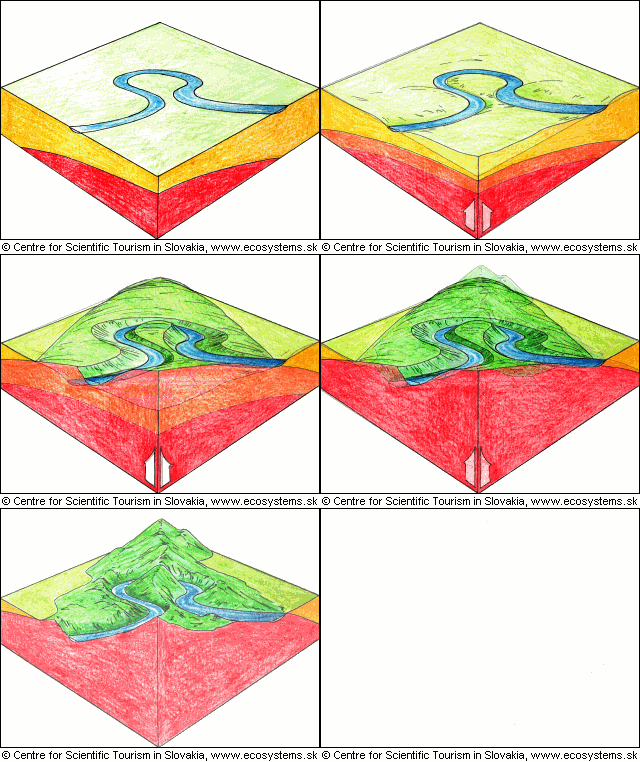
The land is our foundation. And that foundation sits on a deep
geological inheritance that has been unfolding for eons. Our
landscape, both visible and underground, still bears the signatures
that tell the story of the geologic forces that shaped our area. We
can study their bold, unmistakable inscriptions on the surface
where we live.
The ancient sea floors, coral reefs, shore lines, coastal swamps,
tropical river systems, melting ice sheets, and wind-blown dust
produced the earth materials that form the backbone of the land.
The power of water has carved deep valleys through the layers of
rock. Sometimes, the valleys cut deep enough to reach bedrock,
exposing coal seams and tropical plant fossils that formed 400
million years ago.
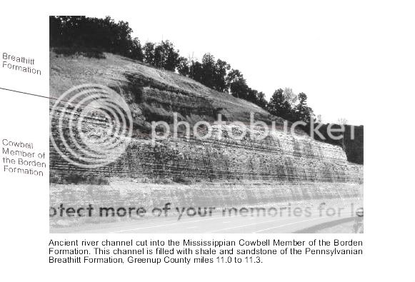
The rock exposed at this ancient river channel cut were formed
during the Mississippian and Pennsylvanian Periods of geologic time
when such water impacts were prevalent. Outcrops of rock that
formed on tropical sea beds 300 to 400 million years ago define the
Ohio River Valley and dictate the sharp bends and narrow channels
of its tributaries. Some streams have cut deep channels into the
rock during the 500,000 years since the region's last glacial
encounter. The broad floodplain of the Ohio River speaks of
torrents of glacial melt water.
When the Appalachian Mountains were uplifted a second time in early
Tertiary Period time , a tilting of the landscape created a
rearrangement of its drainage system. Before the uplifts began, the
master streams, with few exceptions, flowed in northwesterly or
southeasterly directions. But when the land acquired a definite
slant to the southwest, this old drainage system was replaced by a
new system whose master streams flowed in a southwesterly
direction. There is evidence of the strong winding courses of those
ancient streams.
The collisions of continents and the erosion by rivers have left
impacts obvious to even the untrained eye. This ancient river
channel cut is a product of a natural agent of erosion- a stream.
Gradient, discharge, and channel shape influence a stream’s
velocity and the erosion and deposition of sediments. Whether this
ancient river was from the pre or post glacial period is unknown,
but it’s course left a record of it’s existence here where it cut
into the older Mississippian Rock. It’s channel is being filled
with sandstone of the newer Pennsylvania Rock from above.
The course of a river is considered to be from its source of a
spring or melting glacier, through to maturity where it flows into
the sea. Rivers are formed over time chiefly by the processes of
erosion, and by the transport and deposition of sediment. Rivers
are able to work on the landscape through erosion, transport, and
deposition. The amount of potential energy available to a river is
proportional to its initial height above sea level. A river follows
the path of least resistance downhill, and deepens, widens and
lengthens its channel by erosion. Up to 95% of a river's potential
energy is used to overcome friction.
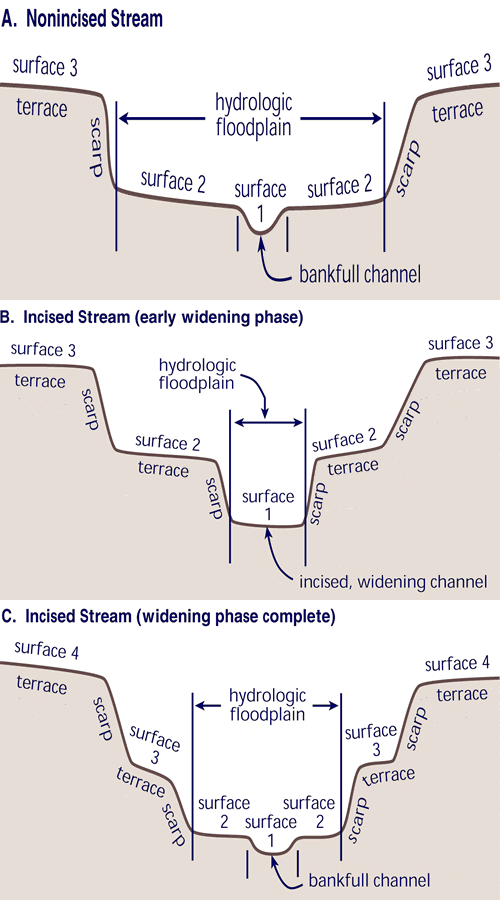
Erosion and deposition are delicately balanced as the river
meanders across a flood plain. “Horizontal Corrasion” is the main
process of erosion. The velocity of the stream current is an
erosive force exerted by water distinct from erosion by the rock
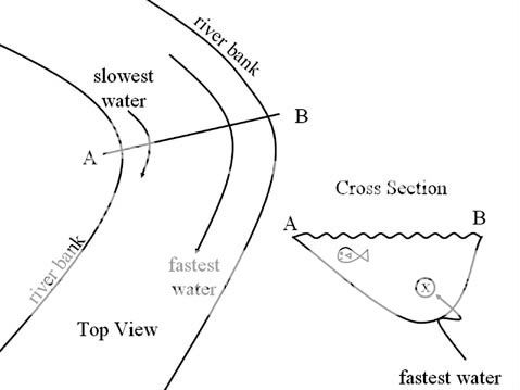
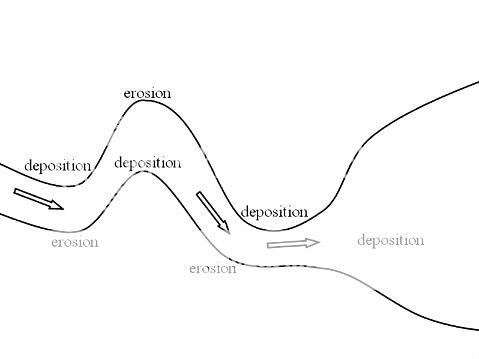
particles that are carried by water. It can wear away the banks of
a river, particularly at the outer curve of a meander (bend in the
river), where the current flows most strongly. Grinding away of
solid rock surfaces by corrasion is done by particles carried by
water. It is generally held to be the most significant form of
erosion in rivers.
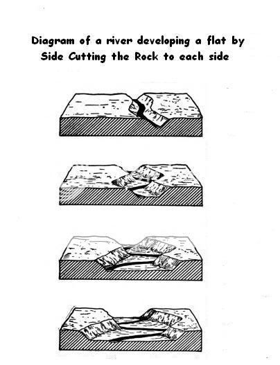
The diagrams below show how erosion and corrasion of streams
horizontally and vertically occur:
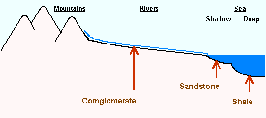
Geologic evidence shows the existence of many different swamps in
Kentucky during the Mississippian and Pennsylvanian time periods.
That tells us that the ocean continued rising and falling, and
sometimes it was covered by shallow seas, sometimes it was a swamp,
and sometimes it was river plains.
Time continues to change the complexion of this particular river
channel cut. Pennsylvanian Breathitt Formation sandstone material
continues to fill in the channel as evidenced by how it looked in
pictures taken just after the road cut was made several years ago
and in photos taken today. Stratified rocks prove less resistant to
the stream horizontal corrasion because the joints and cracks wear
down faster because the water impacts planes of weakness.

To study this ancient river cut in more detail, travel to the
coordinates provided to Mile Marker 11 on the AA Highway in Greenup
County.
Stop at about where the channel cut begins on the rock formation
above you. Mark a point on your GPS.Travel to the opposite end of
the river channel cut and stop.
Write down how far you have traveled to estimate the width the
channel has cut in the Breathitt Formation of Rock.
Study the strata or rock layers and decide where the
Mississippian Period Cowbell Borden Formation Rock that is older
ends and the Pennsylvania Breathitt Sandstone Formation begins.
Estimate how much older rock than newer is exposed here if the
height of the base to top is 200’.
Shoot an elevation for the base of this rock formation.
Shoot a picture of the ancient river channel cut!
Email the correct answers below and post a picture of the Ancient
River Cut into the Mississippian and Pennsylvanian Period Rock here
with your log. Then you too will be a geocaching geologic
sleuth!
1.The width of the ancient river channel cut is:
a/ 100 feet
b/ 150 feet
c/ 200 feet
2. The estimated exposure of rock from Mississippian to
Pennsylvania Period is:
a/ 170 feet Mississippian/ 30 feet Pennsylvanian
b/ 140 feet Mississippian/ 60 feet Pennsylvanian
c/ 110 feet Mississippian/ 90 feet Pennsylvanian
3. What is the elevation of the base of the rock formation
here?
Change is a constant force. We see it as we experience the
changing seasons, the aging of the people around us or in the
development of our physical environment. It is difficult to imagine
the vast changes that occur over centuries and millennia. This
series of earth caches will seek to bring some of the complex
changes of geologic time into perspective. Now buckle up again and
get ready for another new geologic adventure along the AA Highway-
Kentucky’s gateway to the past.
