Many geologists have referred to the AA Highway as a “treasure
trove” and “an outdoor classroom” in which to study diverse and
significant geologic features. Buckle your seat belts and head back
in time and look for the clues as you head down the AA. Each cache
in this series will stop at a unique geologic formation and will
seek answers to some basic questions that should be easy to
calculate. Sizeable pull off areas are available at each stop in
the series. The calculations can be made from your car even, making
it handicap accessible!
Imagine yourself standing on a bleak windswept Ordovician shore. It
is 470 million years ago and you are standing on a rocky coastline
staring out to sea. As you turn and pan the landscape behind you,
all you can see are barren rocks, with no trees, plants or any form
of animal life. You feel the salty wind on your face and the near
total silence is interrupted only by the soft sound of the lapping
tide at your feet. You feel something tickling your toes, look
down, and a trilobite a couple of inches long scuttles across your
foot. You pick it up, see its legs pulsate rhythmically and its
feeble antennae wave. You place it down in the rock pool where it
quickly scurries away under a crevice.

You see another shell of a trilobite in the water, but this looks
different, it has been torn to shreds with puncture marks and you
wonder what creature could have possibly caused this. As you stare
out to sea something disturbs the breakers and the tip of a huge
horn breaks the surface before sinking from view. This is the
Ordovician period, when gigantic cephalopods ruled the seas. The
world span faster on its axis than it does today, a day would have
lasted just twenty-one hours, and no fewer than 417 such days such
days were crammed into a single Ordovician year. The Moon would
have appeared much larger than it does now causing vast tidal
ranges, much more extreme than the present day. The air would have
been harder to breathe, with 15% oxygen and higher levels of carbon
dioxide. The continents were unrecognizable to our modern eyes and
were mostly grouped in the southern latitudes.
The Upper Ordovician strata were deposited in warm, shallow seas
in which marine shell life was locally abundant. The sediments were
deposited without major interruptions; no unconformities or large
hiatuses have been recognized. Sediment accumulation apparently
kept pace with subsidence or sea-level rise. The seas were deepest
during the early part of the Late Ordovician.

The fossils show that life made great progress during this time in
numbers both of individuals and of species. Life in the just ended
Cambrian Period was singularly cosmopolitan. Beside the expansion
of types which abounded in the Cambrian, vertebrate fish remains
are found in the Ordovician. The first relics of insects also
appear. The departure of the Ordovician life from that of the
Cambrian was perhaps most pronounced in the great development of
the mollusks. Corals were also abundant for the first time.
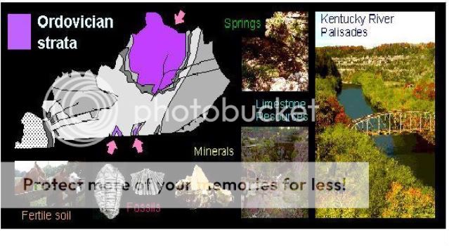
The bedrock in the Bluegrass Region of Kentucky is composed of
limestone and shale from the Ordovician Period. Much of the strata
lies buried beneath the surface. The Ordovician is the oldest
system that crops out in the State. It’s base is not exposed. These
limestone are still quarried for use in construction. Some also
produce natural spring water that is bottled and sold for drinking
water. Approximately 1,400 ft of Ordovician rocks are exposed in
Kentucky. In most areas they are overlain uncomfortably by Silurian
Period rock. By far the largest area of exposure of the Ordovician
rocks is in north-central Kentucky along the crest and flanks of
the Cincinnati arch.

The Middle Ordovician limestone is comprised mostly of sparingly
fossiliferous micrite and dolomite that was deposited in shallow
lagoons and on tidal flats. The Upper Ordovician rocks were
deposited in tropical latitudes in shallow marine water on a shelf
that sloped gently northward. The Later Ordovician strata are
composed of limestone, shale, siltstone, dolomite, and mudstone,
but limestone and shale make up the bulk of the sequence. It is
composed of a whole and broken fossil fragment matrix.

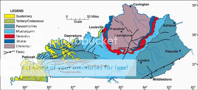
On the geologic map of Kentucky, Ordovician rocks are surrounded by
a ring of Silurian strata (440 to 410 million years ago), shown in
red. Silurian strata consists mostly of limestone and dolostone.
Where these rocks dip beneath the surface area of eastern Kentucky
they are very porous and form natural reservoirs for oil. One can
see that the Silurian rocks do not completely circle the Ordovician
strata, but rather pinch out. Where the Silurian rocks are missing,
Devonian rocks lie directly on top of Ordovician rocks. This is
called an unconformity. An unconformity means that a large segment
of geologic time is missing from the rock record, just as if
someone had torn the pages out of a book.
This particular outcrop represents an unconformity or gap in time
for which strata was laid down between the Brassfield Formation of
the Silurian on the Drakes Formation of Ordovician. Brassfield
Dolomite is the oldest of the Silurian outcrops. It is a carbonate
dominated strata representing the basal part of the Silurian
system. Drakes is composed of dolomite, limestone, mudstone, and
shale. Both are commonly composed of silt-sized grains that are
sparsely fossiliferous. The Drakes Formation generally ranges in
thickness from 10 to 150 feet.

Travel to Mile Marker 25.6 of the Double A Highway Kentucky Route
9/10 in Lewis County to view this outcrop of rare contact between
the Silurian Rock and the oldest rocks exposed in the entire state
from the Ordovician Period. The total outcrop height is
approximately 50’ from top to bottom. Answer the questions below
and email us, then take a picture of what could be a gap of 30
million years in time represented by this unconformity between the
two periods. Then you too will be a geocaching geologic sleuth!
1. Estimate the exposed rock from the two periods.
a/ Ordovician 10 feet/Silurian 40 feet
b/ Ordovician 20 feet/Silurian 30 feet
c/ Ordovician 30 feet/Silurian 20 feet
2. Shoot an elevation for the location of where these old rocks
have outcropped.
The Geologic Map of Kentucky shows the distribution of sedimentary
strata totaling as much as 15,000 ft in thickness and ranging in
age from Middle Ordovician to Holocene. When you visit here,
remember, you are looking at the oldest rocks exposed for viewing
in the state.
Now buckle up and get ready for another geologic adventure on the
AA Highway!
