Devonian Berea Sandstone and Global Warming? EarthCache
Devonian Berea Sandstone and Global Warming?
-
Difficulty:
-

-
Terrain:
-

Size:  (not chosen)
Please note Use of geocaching.com services is subject to the terms and conditions
in our disclaimer.
This series of earth caches is based on the publication “Roadside
Geology Along the Alexandria to Ashland (AA) Highway.” The road
logs were published by the Kentucky Geological Survey to give the
public an appreciation of the geologic world around them.
The Devonian Period was a time of great transition. In the sea fish
evolve and quickly diversify. On land trees and forests appear for
the first time. It is the time of spiders, scorpions and
cockroaches – which will probably be with us forever. 400 million
years ago the continents were moving closer to becoming a super
continent and climate fluctuations were less dramatic.

The rocks in the Devonian System represent a variety of sediments
that have been deposited in a complex environmental setting. These
sediments include clastics, evaporates, and carbonates. In general
the system depicts a transgressive-regressive character of
sequence. This is due to variations of sea level and sedimentation
rates during this period. Fossils deposited in a series of
regressive and marginal marine environments characterizes the
entire system. Strata from the period includes dolomite, limestone,
sandstone and shale. Carbonate rocks of Middle Devonian age make up
the basal part of the Devonian sequence in Kentucky outcrops.
Sandstone beds, or "bone beds," lie locally within or at the top of
the carbonate rocks, as well as within the basal few feet of the
overlying shale.
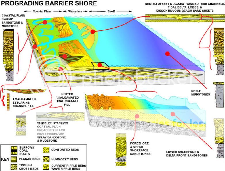
Berea Sandstone is literally the flesh and bones of the hills,
formed from sediment from these varying depositional environments.
It was named for exposures near Berea, Ohio, where it was quarried
at an early date for grindstones. The Berea is fine-grained, but
the grains are angular rather than rounded, which makes this stone
ideal as an abrasive. It has been quarried in many areas as a
building stone and was used for foundations, sidewalks, bridge
abutments, and for buildings.
Berea grit as it is sometimes known, is by far the most important
single stratum in the entire geological column of strata in the
region. Its economic value above ground is great, but it is greater
below. In its outcrops it is a source of the finest building stone
and the best grindstone grit of the country, and when it dips
beneath the surface it becomes the repository of invaluable
supplies of petroleum, gas, and salt-water. Its persistence as a
stratum is phenomenal, seldom reaching a thickness of fifty feet
and reaching scarcely less than 15,000 square miles. It’s
boundaries extend from Ohio with continuity and strength unbroken
into at least four other adjacent States. Traditionally, the Berea
was considered to be of Mississippian age but recently it has been
assigned a Late Devonian age.

The industrial value for construction and yielding gas and oil
reserves is known. But could the Devonian Strata Sequence also slow
the impact of global warming? Scientists believe that a promising
new technology called “geologic sequestration” could reduce the
greenhouse effect by trapping CO2 in the ground rather than
reflecting it back and decreasing the ozone and ice cap melt and
solar radiation to slow the rise of seas. The process would
permanently store carbon dioxide deep underground in carefully
selected geologic formations. The Berea Sandstone is one such
sequence being explored.
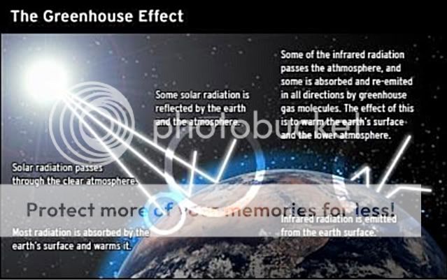
Formations such as sandstone that are permeable and contain pore
spaces would allow the CO2 to spread gradually into the formation
over many years. The technology would utilize low-permeable rocks
above them such as shale to form what is called the caprock which
would seal the CO2 in place and prevent it from moving upward to
the surface. The term caprock is used for one or more layers of
rocks that separate the CO2 injection reservoir from surrounding
strata, especially the freshwater zones nearer the ground surface.
These impervious layers overlie the injection reservoirs and act to
prevent movement of CO2 fluids beyond the injection zones. These
layers have low permeability meaning their ability to transmit
fluids is extremely low. The sandstones are good storage reservoirs
because there of interconnected pore space between the sand grains
that fluids, such as brine, or saltwater, flow easily through them.
The shale little interconnected pore space and does not readily
allow fluid movement, making them a good sealer. Together these
rocks would trap the CO2 in place, much like oil and gas deposits
remain trapped for millions of years.
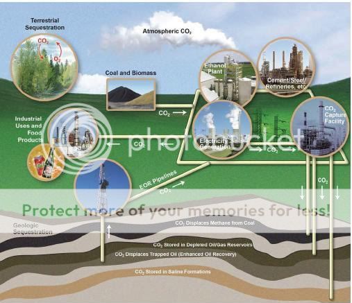
Levels of greenhouse gases have increased by 25% since large scale
industrialization began around 150 years ago. Through carbon
dioxide capture and sequestration, the CO2 would be separated from
industrial emission sources, transported to a storage location and
injected into these subsurface reservoirs ensuring long term
isolation from the atmosphere. There it would remain for long
periods of human time- at least 500 years, which is but a
geological twinkling.
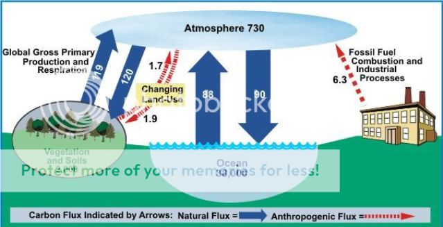
Congress has passed legislation requiring reductions in CO2
emissions to avert greenhouse climate changes. The Midwest Regional
Carbon Sequestration Partnership was formed to assess the regional
technical potential, economic viability and public acceptability of
carbon sequestration. The region consists of seven states including
Ohio and Kentucky and includes over 30 organizations from the
research community, the energy industry and government agencies.
Potential locations for geologic sequestration in the region
include deep rock formations of sandstone and shale associated with
broad sediment formations such as evidenced at this earth cache
location. Geologists will be key players in communicating what
geologic carbon sequestration really is. They will need to educate
the public on carbon storage and it’s potential impacts though
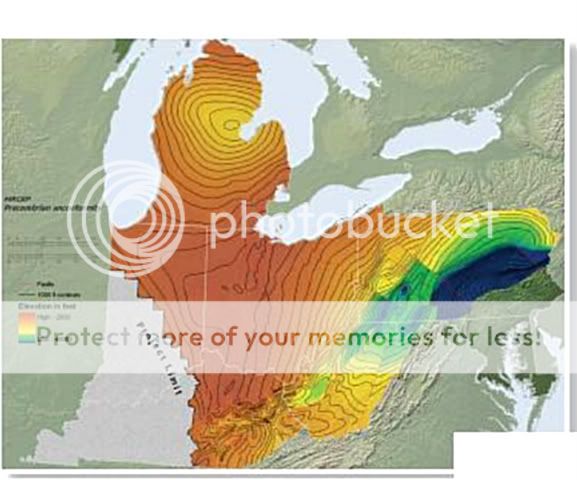
relatively low. Below is a map of Sandstone Sequestration
possibilities in the Region.
Travel to Mile Marker 12.7 to 13.6 along the Double A Highway in
Lewis County to view where the Borden Formations of the
Mississippian Period contacts the Sunbury Shale and Berea Sandstone
of the Devonian Period in the longest and thickest exposure of
Berea Sandstone in Kentucky. Coordinates will take you to a pull
off area where the magnitude of the outcrop is clear. Take a wide
shot of the vastness of the formation.

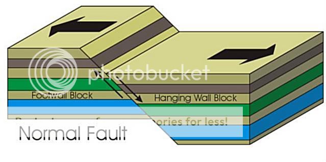
A normal fault can be seen at Mile Marker 12.85 where there has
been an uplift of two walls of the strata division laid down and
deposited. A normal fault drops rock on one side of the fault down
relative to the other side. The slip is defined by the relative
movement of geological features present on either side of the fault
plane. The throw of the fault is the vertical offset. Heave is the
measured horizontal offset of the fault. Take a picture of the
fault. Estimate the heave of the fault.
A cut in the rock at an intersecting road forms a ‘V shape’ at Mile
Marker 13.0 and provides up close viewing of the sequence of the
strata exposed. Measure the break in the formation here.
Email the answers to the calculations below and post a picture of
the formation or the fault with your log. You will need to identify
several features to make the calculations.
1. Estimate the heave (horizontal offset) at the normal fault.
a/ 1-3 feet
b/ 5-7 feet
c. 10-12 feet
2. Estimate the horizontal width at the intersecting road that
forms a natural V.
a/ 100-200 feet
b/ 200-300 feet
c/ 300-400 feet
3. How many rock sequences are represented from the Mississippian
and Devonian Periods?
a/ 2
b/ 3
c/ 4
4. Shoot an elevation of the base of the Berea Sandstone.
It will be interesting to see if these Devonian strata not only
hold the key to an energy starved nation but also play a large role
in reduction of greenhouse gases and a slowing of widespread global
climate change. Buckle Up! It’s time to head on down the AA Highway
again.
Additional Hints
(No hints available.)