VFEC4: Chickies and Antietam (not Pete) EarthCache
VFEC4: Chickies and Antietam (not Pete)
-
Difficulty:
-

-
Terrain:
-

Size:  (other)
Please note Use of geocaching.com services is subject to the terms and conditions
in our disclaimer.
To log this cache, you might want to bring a paper, pen and a camera.
The trail following the west side of Valley Creek provides the opportunity to study the rock of the Chickies and Antietam formations.
The same...
The Chickies and Antietam Formations are both types of sedimentary rocks. This means they are formed by the accumulation of particles derived from preexisting rocks. In this case, both originated as deposits of sand and mud eroded from the continent.
... Yet different
The Chickies Formation consists largely of sand-sized quartz grains while the Antietam Formation contains quartz sand plus a significant amounts of clay and silt. The differences come from the environmental differences when each was formed. Currents and wave action keep smaller particles suspended in the water. Since they are suspended in the water, the clay and silt did not collect on the beaches. What this means is that during the Chickies formation this area was covered by turbulent water. However, later during the Antietam Formation, the water was much calmer, clay and silt was able to settle on the bottom. This clay and silt gives the the Antietam a bit of a darker color also.
The posted coordinates take you to an Antietam formation close to the covered bridge. Notice that this formation weathers into thin platy pieces. The grains of Antietam are much smaller than those of the Chickies. These boulders contain an abundance of platy, reflective grains of the mineral mica. The smaller grains are indicative of the quieter environment in which the Antietam accumulated compared to the Chickies.
Continue on the trail to the additional waypoint. If you look the hill, you will see a massive boulder with a significant portion of it in the ground. This is the Chickies Formation. Looking at it, even from this far, you can see how the sedimentary layers are much thicker than those you saw earlier at the Antietam Formation. The Chickies Formation consists largely of sand-sized light-gray to white, massive or thin-bedded, vitreous quartzite, commonly having spaced mica partings. Thin quartzose schists are locally interlayered with the quartzite. In some specimens, circular to elliptical impressions are visible on flat surfaces. These are sliced through burrows created by worms that lived in the sands about 570 million years ago.
Interesting factoid: Chickies is quarried as a building stone and for aggregate. The stone used to build the restrooms at Valley Forge National Historical Park is Chickies quartzite.
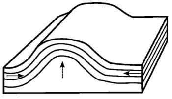
Geologic maps show that the Chickies Formation occurs in the western part of the park and is bordered on the east and south by Antietam Formation. The upward flexure in the rocks is called an anticline . During the mountain building, compression caused the rocks to buckle into folds such as those seen in this area. Later, erosion cause the core of the fold (the Chickies) to be exposed at the surface of Mount Misery.
To log this earthcache:
Draw and post a picture comparing the two different kinds of rock formations you saw. Make sure to label it so I know what is what.
Sources:
http://www.wikipedia.com
http://www.dcnr.state.pa.us/
|
Valley Forge Caching Info:
It is required that cachers stay on marked trails at all times.
Only Earthcaches and virtual stages of caches may be placed on Valley Forge land.
|
Additional Hints
(No hints available.)
Treasures
You'll collect a digital Treasure from one of these collections when you find and log this geocache:

Loading Treasures