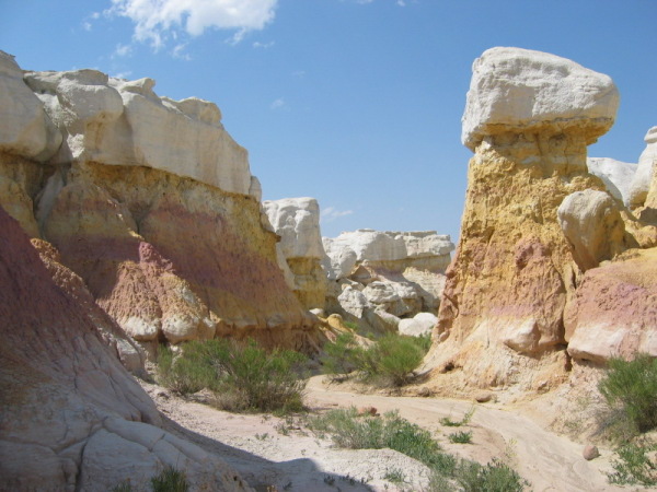
The hoodoos seen at this location are erosional spires that form when a hard cap rock protects a column of more erodible sediment beneath. They form a spire when the material surrounding the cap rock is washed away by rainfall and surface erosion. Hoodoos usually occur adjacent to steep slopes, and are the remnants of the slope as it is eroded back (a well known example is Bryce Canyon National Park). In this area, the hard cap rock of the hoodoo is the white sandstone which protects the colorful clay below from erosion. The rich colors in these formations comes from minerals in the clay which fade from yellow to brown to purple to white over time.
The name "Paint Mines" comes from the fact that this area was a source used by the early American Indians to make their paints and decorate ceremonial pottery. The Indians also used the nearby petrified wood to fashion dart and arrow points. In the 1800's, Euro-Americans settled in the region for agriculture and ranching, and used the clay to make bricks.
Information/Directions: Take Highway 24 east from Colorado Springs to Calhan. Turn south on Yoder Road / Calhan Highway and drive about a mile to Paint Mines Road. Turn east on Paint Mines Road and drive about 1.5 miles to the first designated parking area. The park includes restrooms, and has signs throughout the trail system explaining the geology and ecology of the area. Open 7 days a week from dawn till dusk. Cost is free.
To receive credit for this Earthcache (email me directly; do not post in log):
1). The sandstone seen here is known as the _______ Formation? (It's the layer below the Castle Rock layer.)
2). What mineral creates the bright colors in these hoodoos?
Optional: Post a picture of you with the hoodoos in the background. (Optional as of 1/1/2011)
Extra Credit: Use your GPS to determine the height of the hoodoos (take an elevation reading at the listed coordinates and compare to the elevation at the overlook parking area.