National Road - Indiana Challenge Mystery Cache
National Road - Indiana Challenge
-
Difficulty:
-

-
Terrain:
-

Size:  (small)
Please note Use of geocaching.com services is subject to the terms and conditions
in our disclaimer.
Note: The cache is not at the above coordinates. However, you no
longer have to email the cache owner for the final coordinates when
you complete the challenge. The final coordinates are now public
and shown below. This should help visitors who want to complete the
requirements and get the final on the same trip. Have
fun!
“OLD NATIONAL
ROAD”
The cache IS NOT at the posted coordinates, but the final
coordinates are now visible. You must complete the challenge prior
to finding and signing the final. Instructions for completing the
challenge will be given at the end of this description. But first,
let's talk some history.
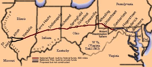
Construction of the National Road was authorized in 1806 with
actual construction beginning in 1811. The eastern terminus of the
road, at that time, was Cumberland Maryland. Cumberland was the
northern extent of the navigable portion of the Potomac River. The
first section of the road would connect the Potomac River to the
Ohio River, somewhere near Pittsburgh. This section of the National
Road would follow the old Braddock Road, which was carved out of
the wilderness in 1755 during Braddock's ill-fated march on Fort
Duquesne during the French and Indian War.
The road would not reach Indiana until 1827. Initially, the route
was going to take the National Road through Columbus in Bartholomew
County, but at the request of state legislators the route was
changed to pass through Indianapolis. The road covers 156 miles
within Indiana. The Indiana portion of the National Road was
completed in 1834.
The original plan was for St. Louis to be the western end of the
road, but money ran out in 1838 and construction stalled at
Vandallia Illinois. Meanwhile, state turnpikes had connected
Baltimore to the National Road in Cumberland.

This photo shows one of the historic buildings along the Indiana
section of the road. This is the Huddleston Farmhouse, just west of
Cambridge City. The house served as an inn for travelers on the
road and also housed the Huddleston family, which had 11 children.
Their house is not on the National Register of Historic Places. The
graves of some of the Huddleston family is nearby and is the site
of an Indiana Spirit Quest cache. Other highlights in Indiana
include James Whitcomb Riley's birthplace in Greenfield and an old
1950's style diner just east of Plainfield. There is also a cache
on an beautiful bridge near Putnamville on an old portion of the
National Road that is separate from US 40.
Today when we think of the National Road, we think of US 40.
However, US 40 was not actually constructed until the 1920's. It
did follow the National Road to a large degree, although there are
spots where US 40 diverts from the original path of the National
Road. Examples of this are State Road 340 in Clay County which
parallels US 40 or the bridge cache in Putnamville that is on an
old remaining portion of the National Road. Still, US 40 assumed
the name of the National Road and does follow the path of the
original National Road to a large degree. US 40 extended the road
all the way to the west coast, making it the first intercontinental
highway and one of the nation's major roads until the construction
of the interstate system in the 50's. A long drive along US 40 is
still a great nostalgic trip and is well worth your while if you
have the time to get off the interstate and see some of the small
towns and main streets of Indiana.
“THE
CHALLENGE”
This is a simple challenge. You must find or place two caches in
each county within Indiana through which US 40 passes. The caches
must be within 1 mile of US 40. One find and one hide is an
acceptable combination.
The following counties are included along this route:
Wayne
Henry
Hancock
Marion
Hendricks
Putnam
Clay
Vigo
You can provide verification of your finds in two ways. Send a GPX
file to the cache owner or create a public bookmark of your finds.
There are no date requirements, so all your finds/hides prior to
the publish date of this cache can be used. When you have provided
proof of your finds/hides along the National Road, you may go for
the final cache. It is also acceptable to sign the log when in the
area of the final, but not log the find until you have complete all
the requirements. When you log your final find/hide, it would be
great if you could post a photo of something interesting you've
seen along US 40. This photo does not need to be at a cache
site.
I've named this the National Road Indiana Challenge in hopes a
similar challenge might be set up in other states along the
national road. Other cachers are welcome to take this idea and
create National Road challenge caches in your states. Have
fun!
Breaking News! MutherandSun has created a National Road
Challenge in Illinois. See
GC1Q888 .
Additional Hints
(Decrypt)
Tb va sebz gur rnfg fvqr.