|
LUSITANI
"Serra da Estrela"

[PT]
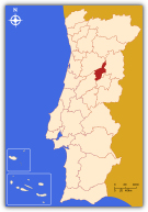 A Serra da Estrela é uma sub-região estatística portuguesa, parte integrante da Região Centro e do Distrito da Guarda. Limita a norte com Dão-Lafões, a leste com a Beira Interior Norte, a sul com a Cova da Beira e a oeste com o Pinhal Interior Norte. Tem uma área total de 872 km² e em 2001 registava uma população de 49.896 unidades. Compreende três concelhos: Fornos de Algodres, Gouveia (Cidade) e Seia (Cidade). A Serra da Estrela é uma sub-região estatística portuguesa, parte integrante da Região Centro e do Distrito da Guarda. Limita a norte com Dão-Lafões, a leste com a Beira Interior Norte, a sul com a Cova da Beira e a oeste com o Pinhal Interior Norte. Tem uma área total de 872 km² e em 2001 registava uma população de 49.896 unidades. Compreende três concelhos: Fornos de Algodres, Gouveia (Cidade) e Seia (Cidade).
Esta é uma região predominantemente montanhosa, nela encontrando-se o topo de Portugal Continental, a Serra da Estrela (que dá o nome à região), com os seus 2.000m de altitude (1.993m mais uma torre em pedra com 7m). Quer de Inverno quer de Verão, são atraídos pelo vasto panorama que se avista da Torre, milhares de turistas.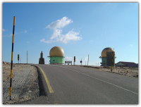
A zona da Serra da Estrela estabelece a separação entre o Norte de Portugal, húmido e atlântico, e o Sul, ainda sujeito a influências climáticas mediterrânicas. É formada predominantemente por granito e, secundariamente, por xisto. Dada a sua altitude é a zona mais fria de Portugal, registando-se no seu ponto mais alto uma temperatura média anual inferior a 7,5ºC, e uma das mais chuvosas, com uma média anual de 2.500mm, tomando a forma de neve nos meses mais frios. Nesta região é ainda a pastorícia que como actividade agrícola se vai sobrepondo e acima de tudo sobrevivendo. Gado bovino, ovino e principalmente caprino constitui a maioria dos rebanhos da zona.
Aqui se situa a Aldeia mais alta de Portugal, o Sabugueiro, capital dos curtumes (artigos em pele). São precisamente as peles e o leite e seus derivados, o sustento das pessoas que ainda vão resistindo nas aldeias espalhadas pelas encostas e entranhas da serra. É daqui também o famoso e não menos delicioso, Queijo da Serra que das muitas queijarias de Fornos de Algodres, Gouveia e Seia, sai com destino ao mercado 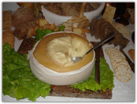 nacional e internacional. Ao nível da indústria era o têxtil com as inúmeras fiações, fábricas de cobertores, cachecóis, xailes etc., que davam emprego às populações de Gouveia, Seia e Loriga. Tendo como energia as muitas linhas de água que escorrem lá do alto da serra, e como matéria-prima a lã de ovelha, foram o sustento da economia da região, restando hoje muito poucas em laboração face à crescente crise do sector. Hoje a região vira-se ao turismo, com o aparecimento de inúmeras empresas e infra-estruturas nomeadamente aquelas ligadas a actividades radicais. Exemplo disso é Gouveia que já é conhecida como a Capital da Aventura, através de actividades radicais internacionais como o Downhill, BTT, Snowboard, Montanhismo, etc. nacional e internacional. Ao nível da indústria era o têxtil com as inúmeras fiações, fábricas de cobertores, cachecóis, xailes etc., que davam emprego às populações de Gouveia, Seia e Loriga. Tendo como energia as muitas linhas de água que escorrem lá do alto da serra, e como matéria-prima a lã de ovelha, foram o sustento da economia da região, restando hoje muito poucas em laboração face à crescente crise do sector. Hoje a região vira-se ao turismo, com o aparecimento de inúmeras empresas e infra-estruturas nomeadamente aquelas ligadas a actividades radicais. Exemplo disso é Gouveia que já é conhecida como a Capital da Aventura, através de actividades radicais internacionais como o Downhill, BTT, Snowboard, Montanhismo, etc.
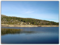
É porventura a região do país com a maior concentração de lagos e lagoas, cerca de 23, que deram azo a muitas lendas e histórias, por exemplo a lagoa escura e a lagoa da paixão (também designada por peixão). As mais conhecidas são no entanto a Lagoa Comprida a 1.600 m de altitude, com o mais comprido paredão (1.200m transitáveis), e cujas águas alimentam várias centrais hidroeléctricas espalhadas pela encosta Norte, e a Lagoa do Rossim a cerca de 1.400 m de altitude localizada no vale que lhe dá o nome, um local bastante aprazível e verdejante procurada no Verão para actividades aquáticas e lazer, principalmente aos fins-de-semana. Possui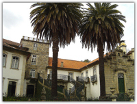 margens relativamente suaves e arenosas que a tornam numa conhecida e frequentada praia fluvial em ambiente de montanha. Algumas infra-estruturas, como o Parque de Campismo, um Café Restaurante e nas redondezas, algumas estalagens e casas de aluguer complementam o cenário idílico. margens relativamente suaves e arenosas que a tornam numa conhecida e frequentada praia fluvial em ambiente de montanha. Algumas infra-estruturas, como o Parque de Campismo, um Café Restaurante e nas redondezas, algumas estalagens e casas de aluguer complementam o cenário idílico.
É nesta zona que nasce o maior rio português, o Mondego, num local conhecido por Mondeguinho, que não é mais que uma pequena fonte à beira da estrada. É também por aqui que se encontra o observatório meteorológico, um dos poucos que no país também mede os níveis de radioactividade e raios ultra violeta.
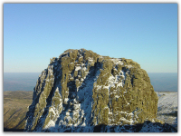
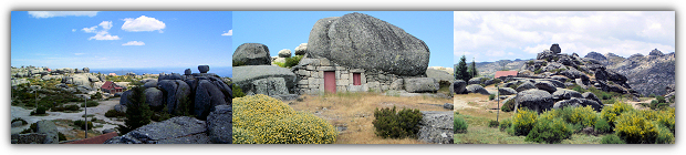
Sobranceiro ao vale do Rossim, estão as Penhas Douradas, a 1.475m de altitude, formações rochosas que devem o nome ao facto de pela manhã, ao nascer do Sol, adquirirem uma coloração… Dourada.
É precisamente nesta zona que se encontra mais uma etapa da cache “LUSITANI”.
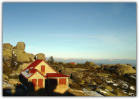 As Penhas Douradas são três penhascos: a Ângela, a Rasa, e a do marco Geodésico. Entre elas distribui-se um casario num local a que se chamou Poio Negro. Primitivamente o local resumia-se a uma pequena casa, a “Casa da Fraga”, edificada em 1882 por Alfredo César Henriques, que mais tarde mandou construir o Sanatório da Covilhã. Ele foi a primeira pessoa tísica a tratar-se na serra, onde viveu durante dois anos, aconselhado pelo médico Sousa Martins. O Casario inclui algumas casas antigas, construídas em rude silharia granítica aparente, uma delas, encaixada num vão criado por um gigantesco bloco arredondado que lhe serve de cobertura. Mais recentemente foram sendo erguidas casas de montanha, em alvenaria e com característicos telhados pontiagudos, algumas delas pintadas com cores vivas, destacando-se na paisagem dominada pelos fraguedos graníticos e pela densa mancha de pinheiros-silvestres, que no Inverno, se tinge com o branco da neve. As Penhas Douradas são três penhascos: a Ângela, a Rasa, e a do marco Geodésico. Entre elas distribui-se um casario num local a que se chamou Poio Negro. Primitivamente o local resumia-se a uma pequena casa, a “Casa da Fraga”, edificada em 1882 por Alfredo César Henriques, que mais tarde mandou construir o Sanatório da Covilhã. Ele foi a primeira pessoa tísica a tratar-se na serra, onde viveu durante dois anos, aconselhado pelo médico Sousa Martins. O Casario inclui algumas casas antigas, construídas em rude silharia granítica aparente, uma delas, encaixada num vão criado por um gigantesco bloco arredondado que lhe serve de cobertura. Mais recentemente foram sendo erguidas casas de montanha, em alvenaria e com característicos telhados pontiagudos, algumas delas pintadas com cores vivas, destacando-se na paisagem dominada pelos fraguedos graníticos e pela densa mancha de pinheiros-silvestres, que no Inverno, se tinge com o branco da neve.
[EN]
 The “Serra da Estrela” is a Portuguese statistics sub-region, integrant part of the Center Region and the “Guarda” District. It limits north with “Dão-Lafões”, east with “Beira-Interior-Norte”, south with “Cova da Beira”, and west with “Pinhal-Interior-Norte”. Has a total area of 872km² and in 2001 a population of 49.896 units. Inside that sub-region is “Fornos de Algodres”, “Gouveia” (City) and “Seia” (City). The “Serra da Estrela” is a Portuguese statistics sub-region, integrant part of the Center Region and the “Guarda” District. It limits north with “Dão-Lafões”, east with “Beira-Interior-Norte”, south with “Cova da Beira”, and west with “Pinhal-Interior-Norte”. Has a total area of 872km² and in 2001 a population of 49.896 units. Inside that sub-region is “Fornos de Algodres”, “Gouveia” (City) and “Seia” (City).
This is a predominantly mountain region, and on it, is the top of the Continental part of Portugal, the “Serra da Estrela” (witch gives the name to the region), with its 2.000m of altitude (1993m plus a tower in rock with 7m). On Winter or Summer, several thousand tourists, are attracted by the beautiful landscape from the place called Torre.
 The “Serra da Estrela” zone, establishes a natural climatic separation between the North of Portugal, wet and Atlantic, and the South, width influences from the mediterranic sea. It is formed predominantly by granite and, secondarily, by shale. Given its altitude it is the coldest place of Portugal, with in its higher point an annual average temperature less than 7,5ºC, and one of rainiest, with an annual average of 2.500mm, snowing in the coldest months. In this region the population lives, mostly, from its cattle, mainly cows, sheep’s and goats. The “Serra da Estrela” zone, establishes a natural climatic separation between the North of Portugal, wet and Atlantic, and the South, width influences from the mediterranic sea. It is formed predominantly by granite and, secondarily, by shale. Given its altitude it is the coldest place of Portugal, with in its higher point an annual average temperature less than 7,5ºC, and one of rainiest, with an annual average of 2.500mm, snowing in the coldest months. In this region the population lives, mostly, from its cattle, mainly cows, sheep’s and goats.
Here is the highest Village of Portugal, the “Sabugueiro”, capital of the tanneries (articles in skin). Skins, milk and its derivatives are the sustenance of the people who still resisting in the villages spread for the hillsides and on the interior of the mountain. The famous and not less delicious cheese named “Queijo da Serra” is fabricated hear in “Fornos de Algodres”, “Gouveia” and “Seia” and is exported to the national and international market. The textile industry, like wiring plants, blankets plants and others, was in the old days the unique industry that gave jobs to the “Gouveia”, “Seia” and “Loriga” populations. Having as energy the water lines that drain from the mountain, and the sheep wool as transforming substance, they had been the economic sustenance for the region, remaining today very few because the increasing sector crisis. Today the region turns to the tourism, with the appearance of innumerable companies and infrastructures in the radical activities field. Example of this is the city of “Gouveia”, already known as the Adventure Capital, through international radical activities as the Downhill, BTT, Snowboard, and others. others, was in the old days the unique industry that gave jobs to the “Gouveia”, “Seia” and “Loriga” populations. Having as energy the water lines that drain from the mountain, and the sheep wool as transforming substance, they had been the economic sustenance for the region, remaining today very few because the increasing sector crisis. Today the region turns to the tourism, with the appearance of innumerable companies and infrastructures in the radical activities field. Example of this is the city of “Gouveia”, already known as the Adventure Capital, through international radical activities as the Downhill, BTT, Snowboard, and others.
It is, almost for sure, the country region with the biggest lakes and lagoons concentration, about 23, with many legends and histories, for example the “Lagoa Escura” (dark lagoon) and the “Lagoa da Paixão” (passion lagoon) also named as “Lagoa do Peixão” (big fish lagoon). However the most known are the “Lagoa Comprida” (Long 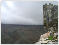 Lagoon) at 1.600m of altitude, with the longest thick wall (1.200m foot-walked), and whose waters feed some hydroelectric-power central offices spread by the North hillside, and the “Lagoa do Rossim” (Rossim Lagoon) at about 1.400m of altitude, located in the valley with the same name, and a beautiful place for aquatic activities and leisure in the Summer, mainly at week-ends. It has a relatively soft edges covered by sand, that transform the lagoon in a mountain fluvial beach. Some infrastructures, as the Camping Park, a Restaurant and nearby some rent houses complements the idyllic environment. Lagoon) at 1.600m of altitude, with the longest thick wall (1.200m foot-walked), and whose waters feed some hydroelectric-power central offices spread by the North hillside, and the “Lagoa do Rossim” (Rossim Lagoon) at about 1.400m of altitude, located in the valley with the same name, and a beautiful place for aquatic activities and leisure in the Summer, mainly at week-ends. It has a relatively soft edges covered by sand, that transform the lagoon in a mountain fluvial beach. Some infrastructures, as the Camping Park, a Restaurant and nearby some rent houses complements the idyllic environment.
In this zone also born the biggest Portuguese river, the “Mondego”, in a place known as “Mondeguinho”, that is not more than a small fountain at the road side. Also there is a meteorological observatory, one of the few in the country that measures the levels of radioactivity. Dominating the valley is a place named “Penhas Douradas”, at 1.475m of altitude, rocky formations witch have received that name because, during the sunrise, they acquire a golden coloration.
It is precisely there that you gonna find another stage of cache “LUSITANI”.
“Penhas Douradas” are composed by three cliffs: the "Ângela", the "Rasa", and the one of the Geodesic landmark. The place between them is known for “Poio Negro”. In the early days there was only one small house, the “Casa da Fraga”, built in 1882 for Alfredo Cesar Henriques, the one that years later ordered the construction of the "Covilhã" Sanatorium. He was the very first person living on the mountain during two years to treat himself from tuberculosis, advised by doctor Sousa Martins. Now there are some old granitic houses, one of them constructed under a gigantic rounded rock. More recently, people constructed concrete houses with sharpness roofs, some painted with shocking colors, making them distinguished from the landscape dominated for big rocks and pine trees. They receive a white coloration in Winter by the snow.
Bibliografia:
- “Portugal Património”, volumes 4 e 5, de Álvaro Duarte de Almeida e Duarte Belo, editado pelo Círculo de Leitores
- Wikipédia – A enciclopédia Livre On-Line.
|
Altitude - 1.544m
[PT] A Cache
Esta cache vai levá-lo a conhecer as Penhas Douradas, local de interesse geológico, bastante calmo e aprazível. Para informações mais completas e pormenorizadas sobre as formações rochosas, aconselho a leitura de um placard informativo junto de uma grande rotunda existente na zona. Para chegar à cache terá de subir a um dos "Tors" tendo especial cuidado no Inverno, mas que no geral não apresenta dificuldades de maior.
A cache é uma vulgar caixa de plástico com os objectos habituais. Por favor deixe-a exactamente onde e como a encontrou.
Dentro da cache, além dos objectos habituais, vai encontrar uma folha especial com um número (Ligada ao LogBook). Por favor anote este número e o nome da cache. Juntando todos os códigos das 30 caches parciais, conseguirá obter as coordenadas da localização da cache final Lusitani, que está escondida algures em Portugal.
Para dúvidas ou esclarecimentos relativos ao projecto global das caches Lusitani, pode contactar os responsáveis pelo projecto: GeoDuplaP&F
[EN] The Cache
This cache will take you into a place called “Penhas Douradas”, it’s a pleasant and calm one, with geological interest. For complete information and detail about the rocky formations, I advise the reading of an informative placard near a big plaza. To found the cache, you will have to go up to one of the “Tors”, having special care in the winter, but that in generally doe’s not present bigger difficulties.
The cache is an ordinary small box with the usual objects in it. Please leave it well hidden as was.
Inside the cache, besides the usual objects, you'll find a special sheet with a number (attached to the logBook). Please note this number and the cache name. Keeping together all 30 partial caches codes, you'll get the way to find the coordinates of the final Lusitani cache, which is hidden somewhere in Portugal.
If you have any doubt or need any clearing about the Lusitani cache project, you can contact the project developers: GeoDuplaP&F
Conteúdo inicial: 6 peças de Lego e uma fita com as cores de Portugal.
|
Lusitani vizinhas » | Dão Lafões | Beira Interior Norte | Cova da Beira | Pinhal Interior Norte | « Neighboring Lusitani
|