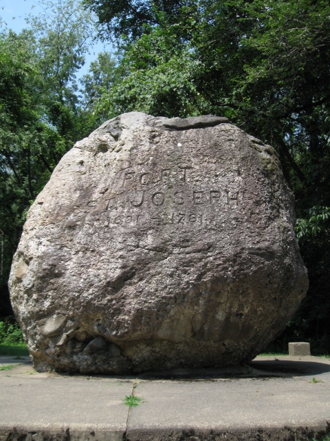
What is an Erratic?
A glacial erratic, as defined by Wikipedia, is a piece of rock that
deviates from the size and type of rock native to the area in which
it rests; the name "erratic" is based on the errant location of
these boulders. These rocks were carried to their current locations
by glacial ice, often over hundreds of miles. An erratic can range
in size from pebbles to large boulders. Geologists identify
erratics by studying the rocks surrounding the position of the
erratic and the composition of the erratic itself. Geologists have
suggested that landslides or rock falls initially dropped the rocks
on top of glacial ice. The glaciers continued to move, carrying the
rocks with them. When the ice melted, the erratics were left in
their present locations.

The last glacier that covered a good part of North America was
approximately 10,000 – 100,000 years ago. This glacier is known as
the Wisconsin Glacier. The Wisconsin Glacier reached north from the
St. Lawrence watershed, west into the Mississippi watershed, east
to New England, but stopped short of the Ohio River to the south.
The advancing ice was channeled into the lowlands now occupied by
The Great Lakes, Green Bay, and the Fox River.
This huge granite bolder was left on a nearby farm from the
movement of ice when the last glacier covered Michigan. In 1912 it
was moved to this location to mark the former site of Fort St.
Joseph. In 1691 the French built a fort here. The fort stood
between here and the St. Joseph River. In 1761 the fort became a
British outpost. During an uprising two years later, Chief Pontiac
seized the fort as well. In 1781 Spanish raiders also had control
of the fort for a few hours as well. This location was a principal
trade route between the Indians, missionaries, and fur traders.
To Log this Earth Cache:
1. Please post a photo with you and/or your team with faces clearly
showing at this location.
2. How high and how wide do you estimate (Use a tape measure or
something to help with the height and paces to estimate the
width).
3. How much do you think this bolder weighs?
4. Using my profile – please email the answers to #2 and #3.
Each Cacher that logs a find is required to submit answers to
the questions above (failure to comply will result in a deletion of
your log). The only exception to this are young kids that are
caching with their parents (who have their own account, but not
computer privileges). Per Earthcache guidelines, each cacher is to
learn from their visit/experience. That means each cacher must
perform the necessary task(s) or requirements to log the cache and
earn your smiley.
Any logs that do not meet the above posted requirements will be
deleted at the discretion of the cache owner. All logging
requirements must be completed within 48 hours of logging the cache
online or your log will be deleted unless you have prior permission
from the cache owner.