Waypoint #1: N38 36.523 and W078 21.969 You can
see a beautiful view of the face of Stony Man Mountain from this
vantage point. Stony Man Mountain is located to the south (directly
in front of you). Imagine for a moment what Stony Man may have
looked like millions of years ago when this mountain was much
younger? What changes had to occur in order for you to be able to
visualize the face of a man?
Stony Man’s face was formed by weathering
and erosion
As you fix your eyes on Stony Man, imagine for a moment that the
Blue Ridge Mountains were once as tall as the Rockies!
The rocks that make up Stony Man’s face are Catoctin
Formation volcanic rocks that erupted and buried Pedlar Formation
Granite. Stony Man’s “beard” is formed by Lava
Flows 1, 2, and 3, his “nose” is formed by volcanic
breccia between Flows 3 and 4, his “eye” is formed by
the contact between Flows 4 & 5, and his “forehead”
is formed by Flow 5 (See Lava Flow Diagram). The process of
weathering has softened the jagged peaks that form the silhouette
of Stony Man’s face.

ASSIGNMENT: Facing south, take a digital photograph of Stony
Man Mountain. What direction is the valley below? What natural
changes had to occur over time in order for you to be able to
visualize the face of a man?
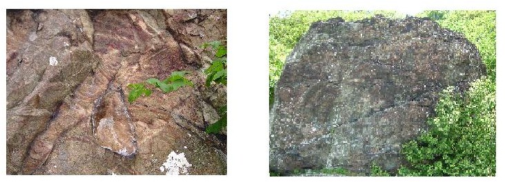
Waypoint #2: N38 36.410 and W078 22.002 You can
see a beautiful example of the Pedlar Formation Granite that has
been hydrothermally altered. A hydrothermally altered rock had to,
at some point, come into contact with heat from magma. Magma
is the hot molten rock within the earth that cools to form igneous
rock. The Pedlar Rock is the oldest in the Park dating to
approximately 1.2 billion years. The source of heat that changed
this rock came from underground magma. Groundwater that flowed
through the fractures in the Pedlar Granite became superheated when
it got close to the magma causing chemical changes to the minerals
in the rock. Let’s put this idea into perspective, the point
at which you are standing was once inhabited by superheated water
that was so hot it had the capacity to change the mineral
composition of the rocks that you are now looking at! These changes
appear in the form of various bands of colors. While not
“hydrothermally” altered, humans experience similar
changes that come with age and experiences throughout our lives
that make us more “colorful” people as well.
ASSIGNMENT: What colors do you see in the hydrothermally
altered rock at this site?
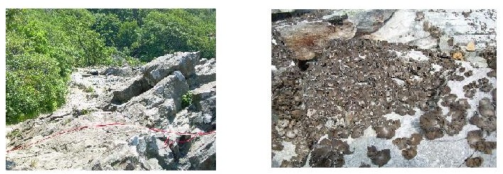
Waypoint #3: N38 36.236 and W078 22.073 Special Navigation
Note: As you navigate to waypoint #3, remember that you must always
stay on the trail! Your compass will be directing you to your next
destination in a straight line, however, as you continue to follow
the trail the arrow will begin to point straight ahead to your
destination.
Here is a picturesque viewpoint of the town of Luray in the
Shenandoah Valley. On a clear day, if you look to the right, you
will see a large manmade lake. It is located outside the Luray town
limits and is named Lake Arrowhead. From this vantage point,
looking west (left), you can also see the New Market Gap where
route 211 passes through the Massanutten Mountains. Looking away
from the overlook, you will notice a large rock outcrop. This rock
is an example of volcanic breccia.
Breccia is a rock created by lava moving broken rubble as it flows.
It is composed of sharp fragments embedded in a fine-grained
surrounding substance. The volcanic breccia contains fragments of
dark red shales and siltstones. Sediment on top of Lava Flow 3 was
already deposited and as Lava Flow 4 advanced over the already
existing rock, it picked up bits and pieces of the rock and moved
them along. If you had the opportunity to stand at this point 570
million years ago, you would have been right in the midst of moving
lava! From this vantage point, you are not standing directly on the
profile of Stony Man’s face. However, you are on the same
Lava Flows that you read about at waypoint 1.
ASSIGNMENT: If the day is clear, take a digital picture of
you and your fellow Cachers holding your GPS units with either the
lake or the gap in the background. If fog has descended or haze has
blocked your view, take a picture near the volcanic breccia. Make
sure you take time to explore the colors and textures of the
volcanic breccia. Also, imagine what it may have been like to feel
the heat from the lava flow and hear the sound of the lava moving
bits and pieces of rock along its path.
WAYPOINT #4: N38 36.205 and W078 22.074 Special Navigation
Note: In order to successfully locate Waypoint #4, you will have to
backtrack from this lower viewpoint until you reach the
intersection where the trail splits. A cement marker is there to
help guide you.
Waypoint #4 will take you to the Upper Cliffs of Little Stony Man.
This viewpoint is not to be confused with the Stony Man Summit. The
Summit can be better accessed by way of a parking area near the
Skyland Resort. Waypoint #4 gives a striking view of the valley
below. This is also a popular destination for rock climbers.
Depending on the time of year you are caching, you may be able to
see the climbers ropes’ draped over the rocks! Standing at
this viewpoint, facing the valley below, you can look to your left
at an even closer view of the Stony Man Mountain Silhouette.
ASSIGNMENT: Since this is a widely traveled area, take a
moment to look for signs of human and natural impact. Do you notice
an organism that is missing from these rock outcroppings? What
visible effects can be observed resulting from human activity in
this particular area? Also, look around and see if there are any
visible signs of the process of nature through weathering and
erosion. Think about ways we, as visitors, can help preserve the
beauty of the National Park for future generations of
visitors.
References:
Badger, Robert, 2004, Geology Along Skyline Drive, Shenandoah
National Park, VA, pg 36-38