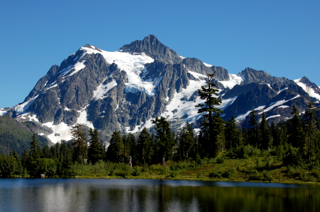
Mount Shuksan, Washington’s tenth highest mountain, is one of the most recognized peaks in Washington due to the fact that its likeness graces a variety of postcards, brochures, magazine covers, maps, and books. It’s often seen in television commercials. Shuksan is best known by its west face, as viewed from Picture Lakes. At this location tourists enjoy a 4,000-foot wall of rock and ice punctuated by Shuksan's notable summit - a large three-sided rock pyramid standing 500-1,200 ft above four encircling glaciers.
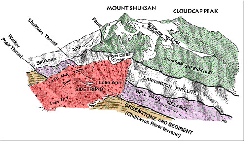
Shuksan is made up of oceanic basalt known as ‘Shuksan Greenschist’. This massive mountain was made approximately 120 million years ago when the Easton terrane smashed into the west coast of North America resulting in its metamorphosis.
 The uppermost terrane in the Western Domain, the Easton terrane, was originally oceanic basalt and overlying deep-ocean mud and sand. The basalt became what has long been called the Shuksan Greenschist; and the overlying sediments became what is known as the Darrington Phyllite. The metamorphosed basalt is not everyday greenschist. Shuksan Greenschist locally contains some unusual blue amphiboles, and the phyllite contains the uncommon mineral lawsonite.
We know from experiments and geologic relations elsewhere in the world that rocks with these minerals (called blueschists if the blue amphibole is abundant) form only where rocks are buried deeply (to mantle depths, in fact) in a relatively cool environment and then regurgitated relatively rapidly. These conditions are most easily met where plates collide in a subduction zone. If the rocks had remained buried for a long time (tens of millions of years) they would have become hot enough for more ordinary green amphiboles and other minerals of high temperature metamorphic rocks to have formed.
Ned Brown (professor of geology at Western Washington University and an ardent fan of the Shuksan Greenschist) and his colleagues have determined that the original ocean-floor basalt and overlying mud and sand may have formed about 150 million years ago (Jurassic). They were metamorphosed some 30 million years later, in the Cretaceous Period.
GLOSSARY OF TERMS:
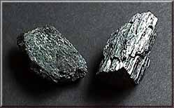
 amphiboles - The amphiboles are a family of silicate minerals that form prism or needle-like crystals. Amphibole minerals generally contain iron, magnesium, calcium and aluminum in varying amounts along with silicon, oxygen, and water. Hornblende, shown in this image, is a common dark green to black variety of amphibole; it is a component in many igneous and metamorphic rocks (see photo to the right).
Cretaceous 145.5 to 65.5 million years ago "The Age of Dinosaurs" The final period of the Mesozoic era. The name is derived from the Latin word for chalk ("creta") and was first applied to extensive deposits of this age that form white cliffs along the English Channel between Great Britain and France.
Darrington Phyllite - a highly folded and faulted phyllite is a mechanically weak rock that easily weathers into small chips and clay-rich residues.
Easton terrain - The surface features of an area of land.
Jurrasic - 199.6 to 145.5 million years ago The middle period of the Mesozoic era. It is named after the Jura Mountains between France and Switzerland, where rocks of this age were first studied
lawsonite - A metamorphic mineral that forms only under very high pressure. It is a calcium aluminum silicate and usually forms microscopic crystals.
oceanic basalt - The dark, dense, aphanitic, extrusive rock that has a silica content of 40% to 50% and makes up most of the ocean floor. Basalt is the most abundant volcanic rock in the Earth's crust.
phyllite - A very fine-grained, foliated metamorphic rock, generally derived from shale or fine-grained sandstone. Phyllites are usually black or dark gray; the foliation is commonly crinkled or wavy. Differs from less recrystallized slate by its sheen, which is produced by barely visible flakes of muscovite (mica).
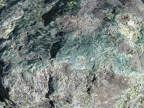
 Shuksan Greenschist - The rock is mostly green - naturally - and generally finely layered, with light and dark greens. Commonly, the foliation and the layering are highly crinkled by folding. The minerals chlorite, epidote, and actinolite color the rock green. The schist, derived from ocean-floor basalt by metamorphism, has a chemical composition just like that of basalt erupted at the mid-ocean ridges (see photo to the left).
subduction zone - Process of one crustal plate sliding down and below another crustal plate as the two converge. The subduction zone is the area between the two plates, somewhat like a giant reverse fault.
TO CLAIM THIS EARTHCACHE:
- Picture Lake is located in the Mt. Baker-Snoqualmie National Forest, and therefore you will need to stop at the Glacier Public Service Center, located at N 48°53.302, W 121°56.288, for a $5 vehicle parking day pass. You can also get current info about the trail and some assistance in getting to the trailhead from the ranger while there. Their hours are daily, 8 am - 4:30 pm, (360) 599-2714.
Looking at the kiosks located along the Picture Lake Path you will be able to answer the following questions (if the signs are down for the season, please email us so we can make arrangements with you to complete the requirements):
- How many feet/meters thick are the glaciers on Mt. Shuksan?
- These glaciers are remnants of massive ice sheets that periodically covered much of North America. Over how many years has this occured?
- During ice advances, the glaciers covering Mt. Skuksan spread and thickened. The ice enveloped the bulk of the mountain and flowed down a sea of ice that covered the lowlands. How deep was that sea of ice?
- Picture lake is in transition. What is causing this transition?
- Take a photo of you and/or your group holding your GPS with Mt. Skuksan in the background. Email (do not log) the answers to questions 2-5 listed above to Three Bottles and post your picture on this Earthcache page.
FUN FACTS:
Skuksan periodically appears displayed backward on calendars and recently so on the cover of a paperback book. Its lithograph image is now seen in China.
In the Pacific Northwest, Mt. Shuksan is the only nonvolcanic peak whose summit exceeds timberline by more than 3,000ft.
The mountain and its four glaciers lie within North Cascades National Park. The Hanging Glacier breaks off periodically and rumbles into the valley below. Skiers report sightings and soundings every winter.
SOURCES:
Cascade Alpine Guide: Climbing and High Routes, by Fred W. Beckey
Climbing Washington's Mountains, by Jeff Smoot
Landslide Risk Management by Oldrich Hungr, Robin Fell, Réjean Couture, Erik Eberhardt
Material on this page has been adapted from a book, Geology of the North Cascades: A Mountain Mosaic by R. Tabor and R. Haugerud, of the USGS, with drawings by Anne Crowder.
Scenic Driving Washington, by Steve Giordano
http://geomaps.wr.usgs.gov/parks/noca/index.html
http://www.usatravelpal.com/states/washington/Mountains/Mount-Shuksan.html
http://geomaps.wr.usgs.gov/parks/misc/glossarya.html