***Please do not place any trade items, trackable
items, or signature items in this container*** We prefer that
visitors focus on the location of the cache and story that the
cache will communicate, rather than trade items. This will also
prevent a cache from containing items that may attract
wildlife.
Although trade items, signature items, and trackable items are not
allowed in this geocache, you are allowed to dip trackable items
for miles only.
*** Veuillez ne placer aucun article commercial dans ce récipient -
nous préférons que les visiteurs se concentrent sur l'endroit de la
cachette et de l'histoire que la cachette communiquera, plutôt que
les articles commerciaux. Ceci empêchera également une cachette de
contenir les articles qui peuvent attirer la faune.
Height of Land Tower - Tour de la
Ligne-de-partage
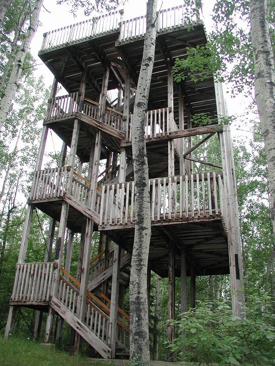
It is an easy climb up the ten metre tower for a
panoramic view of the boreal forest.
Cette tour de 10m se grimpe facilement et vous donne accès à une
vue impregnable sur la forêt boréale.
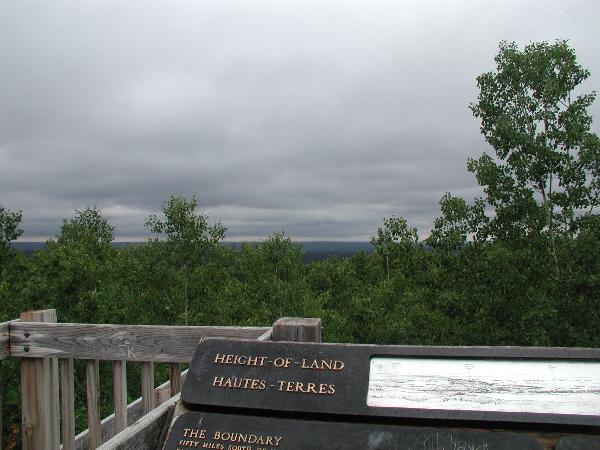
Fifty miles south, the Saskatchewan River flows through grasslands
and grainfields. One hundred miles to the north, the Churchill
River traverses a land of rock and forest. The Height of Land Tower
is a boundary separating two river systems and two
environments.
A 50 milles au sud, la Riviére Saskatchewan coule à travers les
prairies et les champs de blé. À 100 milles au nord, c’est la
Riviére Churchill qui, elle, traverse des regions boisées et
rocailleuses. Cette tour a été érigée sur l’élévation de terrain
qui, veritable frontiére, sépare ces deux basins, ces deux types
d’environnement.
When commerce came to the Prince Albert area, Lumbermen
turned northward to meet it’s demands. The forests supplied lumber
for a developing industry, where rivers supplied the means of
transport. A few miles up Beartrap Creek, a low, narrow ridge on
the Height-of-Land separates the creek and the Spruce River. To
help float logs down the Spruce River, Beartrap Creek was dammed
and a canal was dug through the Height-of-Land. In this way, waters
bound for the Churchill River were diverted into the Saskatchewan
system. The age-old boundary between the watersheds was broken.
After the area became a National Park in 1927, the canal was filled
and the dam opened. Today, timber has returned, lumbering and dams
are the beaver’s work, and Beartrap Creek follows it’s former
course.
Lorsque Prince Albert devint une région commerciale, les
bûcherons se tournérent vers le nord pour satisfaire à la demande
en produits forestiers, créé par l’industrie naissante. La forêt
fournissait le bois,et les rivières le moyen de transport. À
quelques milles en amont du ruisseau Beartrap, une légère elevation
de terrain séparait ce ruisseau du bassin de la Rivière Spruce.
Pour permettre le flottage du bois sur la Rivière Spruce, on fit un
barrage sur le ruisseau Beartrap et Saskatchewan. On venait de
faire une brèche dans la très ancienne frontière. Après
l’établissement du parc national, en1927, le canal fut rempli et le
barrage ouvert, aujourd’hui les arbres ont repoussé, les castors
sont les seuls bûcherons et constructeurs de barrages, et le
ruisseau Beartrap suit son ancien cours.
Due south the next hill is Delworth Hill. In the
80-foot-high Bluebell Fire Tower, which was located here until the
late 1900’s, the forest was under the watchful eye of a fire
observer. Today, that task is performed by satellites assisted by
aircraft reconnaissance when “hot spots” are detected.
En plein sud, la colline Delworth, se profile devant vous. Du
haut des 80 pieds de la tour d’observation Bluebell, qui se
dressait ici jusqu’à la fin du XXe siècle, un observateur
surveillait la forêt, attentive à tout signe annonçant un incendie.
Aujourd’hui cette tâxche est execute par des avions de
reconnaissance munis de satellites qui détectent des « points
chauds ».
This cache has been approved by Parks Canada. If you have any
questions about this cache or about geocaching at Parks Canada,
please contact geocache@pc.gc.ca.
Cette cachette a été approuvée par Parcs Canada. Si vous avez
n'importe quelles questions au sujet de cette cachette ou au sujet
de geocaching aux Parcs Canada, entrez en contact avec svp le
geocache@pc.gc.ca