The water in an artesian well flows from an aquifer, which is a layer of very porous rock or sediment, usually sandstone, capable of holding and transmitting large quantities of water. The geologic conditions necessary for an artesian well are an inclined aquifer sandwiched between impervious rock layers above and below that trap water in it. Water enters the exposed edge of the aquifer at a high elevation and percolates downward through interconnected pore spaces. The water held in these spaces is under pressure because of the weight of water in the portion of the aquifer above it. If a well is drilled from the land surface through the overlying impervious layer into the aquifer, this pressure will cause the water to rise in the well. In areas where the slope of the aquifer is great enough, pressure will drive the water above ground level in a spectacular, permanent fountain. Artesian springs can occur in similar fashion where faults or cracks in the overlying impervious layer allow water to flow upward. Water from an artesian well or spring is usually cold and free of organic contaminants, making it desirable for drinking.

The Mississippian (359 to 318 Mya) aquifer is present in Michigan and Iowa. In Michigan this aquifer is called the Marshall aquifer as the principle stone that transports it's water is the Marshall Sandstone from this era. It underlies much of the Lower Peninsula. The aquifer consists mainly of siltstone and medium-grained sandstone. The aquifer is overlain either by Pennsylvanian (318 to 299 Mya) or younger rocks that confine the aquifer and restrict ground-water circulation. The aquifer is under laid with the Coldwater shales. Where the Marshall aquifer forms the bedrock surface, the aquifer generally is overlain by the aquifer that flows through the glacial deposits on the bedrock's surface. The Marshall aquifer generally is unconfined in this area and is hydraulically connected with extremely permeable glacial deposits.
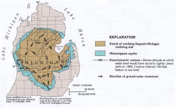
Recharge to the Marshall aquifer is principally where the aquifer forms the bedrock surface and is directly overlain by and hydraulically connected with the superficial aquifer system to the north and the south of overlying Pennsylvanian rocks. Recharge from precipitation and from lakes and streams is through the superficial aquifer system. Water moves into the aquifer at high areas on the surface to the north (1,100- and 1,000-foot contours) and to the south (1,000- and 900-foot contours), as shown in the following image. Water moves from these recharge areas down the hydraulic gradient to Saginaw Bay on the east and to Lake Michigan on the west.
The Marshall aquifer is one of the most important and productive aquifers in the State. Although much of the Marshall aquifer is confined or semi confined, unconfined conditions occur locally in the area where the aquifer forms the bedrock surface. The aquifer ranges in thickness from a feather edge along the periphery to about 1,000 feet in the center of the Michigan basin. The Marshall aquifer is used only in the southern part of the State and in the Saginaw Bay area because elsewhere either it contains water that is too salty for use or shallower aquifers are available.
Withdrawal of freshwater from the Marshall aquifer during 1985 totaled 45 million gallons per day in Michigan. In the state, 45 percent of the freshwater, or about 20 million gallons per day, was used for industrial, mining, and power purposes. Public supply was the second principal use of freshwater from the aquifer at 34.2 percent of the total, or about 15.4 million gallons per day.
Artesian wells are often over exploited because their water is fresh and easily available, and they eventually become unreliable. There is also some concern that pollutants such as pesticides or nitrates can seep into the aquifers.
In Europe this mode of well-boring was first practiced in the French province of Artois (Latin Artesium), a historical region of northern France, on the Strait of Dover, whence the name of Artesian is derived. At Aire, in that province, there is a well from which the water has continued steadily to flow to a height of 11 feet above the ground for more than a century. Within the old Carthusian convent at Lillers, another which dates from the 12th century, and which still flows. Traces of much more ancient bored springs appear in Lombardy, Asia Minor, Persia, China, Egypt, Algeria, and even in the Sahara desert.
Logging requirements:
1.) Post a photo of your face, GPS and the well in the background with your online log.
2.) Email me at here with the GPM of flow this well at the time of your visit. Using a container of a known volume (a bucket in even gallons makes it easier). Use this formula to calculate the flow rate in GPM (gallons per minute). SIZE / TIME = VAR1
VAR1 * 60 seconds = GPM
Where:
SIZE is the volume of the container in gallons
TIME is the amount of seconds it took to fill your container
VAR1 is a temporary value
GPM is your answer in gallons per minute
3.) Enjoy a drink if you like. The locals come here to fill jugs to take with them.
This well was restored by the Elkton Woman's Civic Club in 1983.